Route Editor

| Guide | ♦ | 6 Triplogs | 0 Topics |
details | drive | permit | forecast | 🔥 route |
stats |
photos | triplogs | topics | location |
| 28 | 6 | 0 |
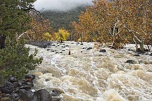
High water route to the Red Ledges by montezumawell   This Hot Loop Trail #94 / Woods Canyon Trail #93 combo is a high water access route to the Red Ledges of Woods Canyon and Dry Beaver Creek. When the flow of Dry Beaver Creek is running several hundred cubic feet per second (CFS), the normal access route on the Woods Canyon Trail is flooded. Water flows through various small channels about a mile from the trailhead just upstream from the register box. Therefore, the only way to get in to see some rowdy high water at the Red Ledges is via the Hot Loop Trail. This Hot Loop Trail #94 / Woods Canyon Trail #93 combo is a high water access route to the Red Ledges of Woods Canyon and Dry Beaver Creek. When the flow of Dry Beaver Creek is running several hundred cubic feet per second (CFS), the normal access route on the Woods Canyon Trail is flooded. Water flows through various small channels about a mile from the trailhead just upstream from the register box. Therefore, the only way to get in to see some rowdy high water at the Red Ledges is via the Hot Loop Trail.It's a little longer and entails a lot more vertical gain. But the payoff is worth it. The Red Ledges are a fine destination even when they are bone dry. Their magnet-factor is increased in proportion to the streamflow. Fifty CFS is great. A hundred CFS is super. Five hundred is awesome. Seven hundred is spectacular. Anything above that is truly fantastic. However, the odds of actually seeing Dry Beaver flow at the high levels are very, very low. Only once in a long time will this stream get rocking and rowdy with high flows.
We have been fortunate enough so far to visit the Red Ledges three times while the lower Woods Canyon Trail has been flooded. Once on November 22, 2004, and again on January 11 and 12, 2005. The flow in November was roughly 750 CFS and about 2,500 CFS on January 11. The next day it had dropped sharply to around 600 CFS. So viewing high water at the Red Ledges is the reason for the Hot Loop to Woods trail description. The Hot Loop Trail leaves the parking area to the west side of the chute(as mentioned in the directions below). You will see an iron gate. Walk alongside the cattle pen. There is a rather confusing array of braided trails not far ahead. Simply walk straight ahead and avoid going over to the metal sign marking the Hot Loop Trail. You will note all the various braids join back up into a logical, well-worn route. The trail comes within spittin' distance of a large home on your right. Continue past this residence and stay on the most heavily traveled trail. Numerous small "social trails" lead into adjacent private property. You are heading for a small saddle on the horizon. The trail is straightforward and the tread is not too rubble-filled. The trail can remain quite muddy well after recent rain. After you top out at the saddle, the Hot Loop Trail follows a nicely designed hiking route down into a drainage that flows west off of nearby Horse Mesa. About 1.75 miles from the trailhead, just after you cross the slickrock drainage, you will come to a much larger trail. This is an old bulldozed jeep trail that is now part of the Hot Loop Trail. If you go left, you will climb atop Horse Mesa. Turn right and head downhill. Eventually, you will come to another trail--the Woods Canyon Trail. You can't miss it. There's both a metal and a wood sign there marking the other end of the Hot Loop Trail. Turn left here and leave the bulldozed ancestral jeep trail behind. You are now on a fine hiking trail that winds through an intriguing riparian forest. Occasionally, you will see Dry Beaver Creek off to your right. You have about another 1.25 miles to go to the Red Ledges. There are two dangerous areas of this portion of the trail. You will climb slightly up out of the forest and walk along a narrow tread in loose red sandstone. Look up to your left. See all the rocks precariously perched on the rubble bluff. Rockfalls are very common here. They generally happen during and/or immediately after a rainstorm. Some of the rockfalls can be quite extensive. And some of the individual falling rocks can be quite large. You will note various other places where the rocks are on a roll, so to speak. The Red Ledges area can be quite spectacular when the water is running high. At least four large streams are flowing across the face of Rattlesnake's alluvial fan. Each is a significant watercourse in its own right. And all are captivating photo ops. The USGS map indicates Dry Beaver Creek somehow "begins" at this point. At the high flows, it's a lot easier to visualize than when the area is bone dry. Allow at least four hours for this trip. Five is better. It's not a place you will want to glance at and turn right around to hike out. This is a destination to savor and enjoy. Who knows when it will run this big again? Gate Policy: If a gate is closed upon arrival, leave it closed after you go through. If it is open, leave it open. Leaving a closed gate open may put cattle in danger. Closing an open gate may cut them off from water. Please be respectful, leave gates as found. The exception is signage on the gate directing you otherwise.
Check out the Official Route and Triplogs. Leave No Trace and +Add a Triplog after your hike to support this local community. | |||||||||||||||||||||||||||||||||||||||||||||||||||||||||||||||||||||||||||||||||||||||||||||||||||