 Route Editor

| Guide | ♦ | 19 Triplogs | 1 Topic |
details | drive | permit | forecast | 🔥 route |
stats |
photos | triplogs | topic | location |
| 6 | 19 | 1 |
Old Hot Trot by joebartels   FS Summary FS SummaryTwo things are hot about this trail. That's the way you'll feel when you complete the climb to the top of Horse Mesa and that's the way you'll describe the views when you get there. There are two ways to approach the Hot Loop, one is from a trailhead in Jacks Canyon near the Pine Flat Subdivision. The other is a trailhead in Woods Canyon off AZ 179. From the Jacks Canyon Trailhead (which has the best parking lot) a connector trail leads up and over a low saddle to join the Hot Loop just as it begins the steepest part of its 1,000-foot climb to the top of Horse Mesa.
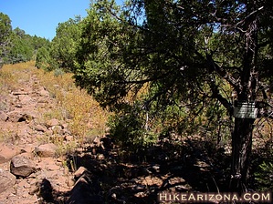
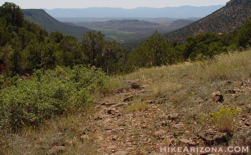
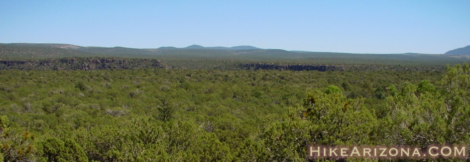
If you start your hike from Woods Canyon, you might keep in mind that this stream can quickly turn into a flood during the spring snowmelt or after a summer thunderstorm. If that happens, the canyon bottom jeep road can become part of the stream. 2001-09-09 Summary (rather useless now but it's from the HAZ founder, so bear with us...) Overview This is a 4.1-mile hike out on the Hot Loop #94 Trail and back by the same route. This hike takes you up onto Horse Mesa near topo "x" mark 5284 which is an overlook of Horse Mesa Tank (not exciting). Going further involves rougher terrain and route finding. Summary Unless you've come looking for this trail it's probably not for you. In fact, I wouldn't have included the trail on-site except I came across a small perk on the return trip. Between Jacks and Woods Canyon lies Horse Mesa. The Hot Loop Trail starts down at the Jacks Canyon trailhead. Then it does a small back loop up onto Horse Mesa. Here it follows the mesa up to the rim. You could actually take Jacks Canyon Trail back down to your car. Before you get all excited we're talking about an eighteen-mile loop that's anything but easy. The trail was used to move cattle up onto the mesa and rim for grazing in the summer. A hot-loop is branding iron. Don't get confused as this isn't a loop trail. From the Jacks Canyon Trailhead look for the loading coral in the distance. Here the trail starts by going through a horse gate on the right of the loading coral. My best guess is high school kids hang out here on Fridays and Saturdays judging from the graffiti. It makes you wonder if they get busted for beer or not having a red rock pass...lol At any rate, head out on the trail and put those thoughts behind. The trail heads southwest to gain a saddle or a dip in the mesa. It's a little over a 200-foot elevation gain and mile to the saddle. Before reaching the saddle you'll pass two or three trails taking off to the right. These lead to the homes nearby. Folks take their horses out onto the trail, so watch out for the land mines. Once on the saddle, the trail descends a tad on the flip side. It's almost half a mile to the junction you need. Coming down from the saddle you'll pass a log fence terminus. Shortly after is a slab of red rock. There's a small energy field around this area. New Agers needn't get all excited as it's not a warm-fuzzy-positive energy field. It likely came about to keep cattle from overgrazing the area above and help influence them to turn back. Don't ask! At any rate... continue on to the junction. No signs mark the junction, but it is obvious. It's a hairpin junction and you ascend immediately. The ascent up the mesa is hearty but nothing to get worried about. Around 2.25 miles in you'll pass into the Munds Mountain Wilderness. There isn't a fence or gate marking the boundary. However, there is a small sign tacked to a tree on the right. If you somehow managed to make it to this point on your bicycle you can't take it any further. There seriously are bicycle track traces so don't think I'm taking ya for a spin! You might look behind you as there won't be many distant views up on the mesa. Further up onto the mesa the going gets easier. Around 2.65 miles in is a short side trail to your left. The GPS coordinates are N34 46.937, W111 42.890. It's under fifty yards to the rim on this side trail. I completely missed this side trail going out and caught it on the return trip. The views from the edge are very nice. More so, one small boulder looks to be the perfect seat for viewing a sunset. Serious face suckers might consider bringing a small yet thick blanket as the rock is a bit rough. A couple of things I noted... Although on top of the mesa you can't see very far due to all the trees, none of which provide much shade. The trail is pretty much totally exposed. I don't recommend going early September as I did. Although very warm, I wasn't annoyed by any bugs. I guarantee you'll encounter constant attacks in similar weather in May and June! Wildflowers when in season literally blanket this area in a sea of yellow. I caught the dying stage (boo). I continued on almost another mile and a half until a view of Woods Canyon came into play on a high point. The view isn't anything to get excited about. You can barely make out the canyon. I really don't recommend coming out this far unless you plan on going further. According to map had I continued another three quarters of a mile the trail does skim the edge of Woods Canyon for a good stretch. After that, there's a brutal 900-foot ascent straight up to the rim. Gate Policy: If a gate is closed upon arrival, leave it closed after you go through. If it is open, leave it open. Leaving a closed gate open may put cattle in danger. Closing an open gate may cut them off from water. Please be respectful, leave gates as found. The exception is signage on the gate directing you otherwise.
Check out the Official Route and Triplogs. Leave No Trace and +Add a Triplog after your hike to support this local community. One-Way Notice This hike is listed as One-Way. When hiking several trails on a single "hike", log it with a generic name that describes the hike. Then link the trails traveled, check out the example. | |||||||||||||||||||||||||||||||||||||||||||||||||||||||||||||||||||||||||||||||||||||||||||||||||||||||||||||||||||||||||||||||||||||||||||||||||||||||||||||||||||||||||||||||||||||||||||||||||||||||||||||||


