 Route Editor

| Guide | ♦ | 26 Triplogs | 0 Topics |
details | drive | no permit | forecast | route |
stats |
photos | triplogs | topics | location |
| 260 | 26 | 0 |
off trail climbing by OhOh7 Notice
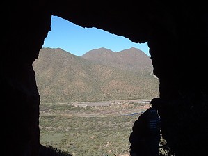
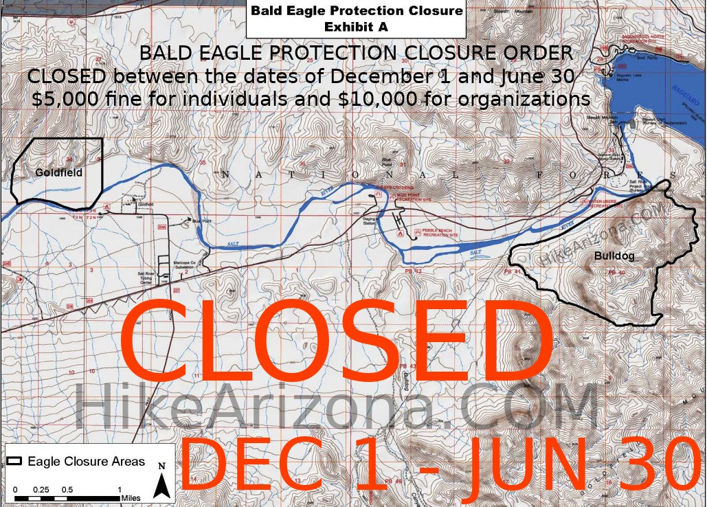
An area of this hike is closed Dec 1st - Jun 30th.  Five of us started at the Blue Point trailhead, just off Bush highway by the Salt River, excited that we were going to see one of the Goldfield Mountains secrets. These mountains have many natural arches. Most hikers do not know this, nor have they been to any of them because there are no trails throughout most of these mountains. There are a few faint jeep roads around the lower elevations, but the majority of hiking will be off-trail. Five of us started at the Blue Point trailhead, just off Bush highway by the Salt River, excited that we were going to see one of the Goldfield Mountains secrets. These mountains have many natural arches. Most hikers do not know this, nor have they been to any of them because there are no trails throughout most of these mountains. There are a few faint jeep roads around the lower elevations, but the majority of hiking will be off-trail.Today we headed for the Sunrise Arch [ View Location ]. It is not marked on any map that I could find. The arch goes through an outcropping of rock with a rock cliff directly behind it, so it is challenging to pick out from afar. Even getting close to it, one finds it hard to make it out. However, once at the arch, it is an astounding feat of nature, as some of my photos will show. I found it is even hard to get good photos due to the background. However, the actual arch is about 25 feet high and 30 plus feet across. It has a saguaro growing on top of it. It is called the Sunrise Arch because the sun from the east shines through the arch at one point in the morning. At all other times, it simply blends into to rocky backdrop.
The entire hike is rated a "B" because the amount of actual climbing is almost 1500 feet with lots of down and up areas before the final up push. We returned to the trailhead by a different route that tended to hug the foothills more until we went through Gateway Canyon and down to the river level banks. The green grass is amazing for Arizona. When these trees bloom and the flowers come in a couple of months, this area will be breathtaking. The entire hike took us just over 5 hours as we lunched in the arch. This arch's location is almost directly south of the tubing parking area lot on the Salt River. However, I don't think you will see the arch with the naked eye unless you know exactly where to look. Good binoculars can spot it. Of course, since there are no trails, there are many ways to get to the arch. We selected leaving from the Blue Point trailhead as there is parking available there that seems fairly safe. If one were to go up Gateway Canyon, you could get to the top and see 2 or 3 more arches and get to Sky Island. From Sunrise Arch, we inspected some way up, but it was too steep. We actually went to the arch, through it, and down the other side. The grass was very abundant. There was lots of water in various places coming down the rocky cliffs and in the ravines. The Salt River even had a few rapids! I highly recommend this hike. The views are tremendous, and the "surprise" of seeing the large arch and going to and through it is well worth the experience. In a couple of months, the natural color will be brilliant. I do particularly thank Ted, the hike leader. He not only has the experience to lead us on off-trail hikes but was kind enough to wait for anyone who needed more time to climb certain challenging areas to keep the group together. I did not feel hurried, and even though this hike had some difficult sections, I felt I could take my time to be safe.
Check out the Official Route and Triplogs. Leave No Trace and +Add a Triplog after your hike to support this local community. | ||||||||||||||||||||||||||||||||||||||||||||||||||||||||||||||||||||||||||||||||||||||||||||||||||||||||||||||||||||||||||||||||||||||||||||||||||||||||||||||||||||||||||||||||||||||||||||||||||||||||||


