Route Editor

| Guide | ♦ | 43 Triplogs | 1 Topic |
details | drive | permit | forecast | map |
stats |
photos | triplogs | topic | location |
| 719 | 43 | 1 |
Canyons are inherently risky. Flash floods occur without notice on sunny days. Technical skills & surrounding topography knowledge required yet does not eliminate risk.
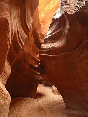
Easy hidden slot canyon by PaleoRob   Waterholes Canyon is a slot canyon just south of Page. Its one of the last tributaries to lower Glen Canyon before the Colorado River emerges at Lee's Ferry to enter Marble Canyon. Waterholes is not as famous as nearby Antelope Canyon, nor is it as deep. It shares many characteristics with another nearby tributary to the lower Glen, Nine Mile Draw. There are two portions to Waterholes Canyon, and they are divided between Upper and Lower at the point where the highway bridge for US89 crosses the canyon. Recently the Navajo Nation has closed the lower section of Waterholes Canyon to hikers. Fortunately, the upper section is still open to hiking. Since it is on Navajo land, you'll need to get a hiking permit. Waterholes Canyon is a slot canyon just south of Page. Its one of the last tributaries to lower Glen Canyon before the Colorado River emerges at Lee's Ferry to enter Marble Canyon. Waterholes is not as famous as nearby Antelope Canyon, nor is it as deep. It shares many characteristics with another nearby tributary to the lower Glen, Nine Mile Draw. There are two portions to Waterholes Canyon, and they are divided between Upper and Lower at the point where the highway bridge for US89 crosses the canyon. Recently the Navajo Nation has closed the lower section of Waterholes Canyon to hikers. Fortunately, the upper section is still open to hiking. Since it is on Navajo land, you'll need to get a hiking permit.The hike begins at the trailhead just north of the highway bridge over Waterholes Canyon, on the road's east side. There are a gate and a hiker's maze that mark the highway right-of-way boundary. Once through the hiker's maze, there is a well-worn and obvious path leading towards the right and the canyon rim. This leads to a small, easily descended draw. At one point, you will reach a seeming impasse, with a cliff on the right and a boulder-jam on the right. Climb over the boulders, which is very easy, and the slope leads into another steep draw, which will take you right to the floor of Waterholes Canyon. Downstream you can see the highway bridge, while upstream are alternating narrows and broader canyon bottoms.
Gate Policy: If a gate is closed upon arrival, leave it closed after you go through. If it is open, leave it open. Leaving a closed gate open may put cattle in danger. Closing an open gate may cut them off from water. Please be respectful, leave gates as found. The exception is signage on the gate directing you otherwise. Check out the Triplogs. Leave No Trace and +Add a Triplog after your canyon trip to support this local community. | ||||||||||||||||||||||||||||||||||||||||||||||||||||||||||||||||||||||||||||||||||||||||||||||||||||||||||||||||||||||||||||||||||||||||||||||||||||||||||||||||||||||