Route Editor

| Guide | ♦ | 23 Triplogs | 0 Topics |
details | drive | no permit | forecast | map |
stats |
photos | triplogs | topics | location |
| 267 | 23 | 0 |
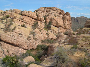
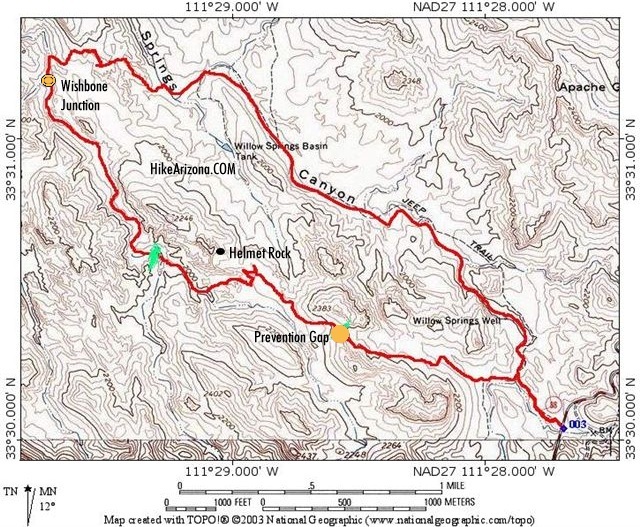
90% bushwhacking by OhOh7  This was my 4th hike in the Goldfields with lots of off-trail bushwhacking. You start from highway marker 204 on the Apache Trail and follow the jeep road toward Willow Springs Canyon ( the north part not in the Superstitions) and then veer to the west until the faint road dead ends. Next, head out NW for several miles with no trail at all. The object is to do a loop around the helmet which is a rock dome that looks like a helmet and follows some creek beds that all dump into Willow Springs. This was my 4th hike in the Goldfields with lots of off-trail bushwhacking. You start from highway marker 204 on the Apache Trail and follow the jeep road toward Willow Springs Canyon ( the north part not in the Superstitions) and then veer to the west until the faint road dead ends. Next, head out NW for several miles with no trail at all. The object is to do a loop around the helmet which is a rock dome that looks like a helmet and follows some creek beds that all dump into Willow Springs.The hike route is relatively easy with many spectacular views of Weavers Needle, Flatiron, Golden Dome and Dome mountain with the 4 peaks always a landmark to help orient direction. I find that I really do like the bushwhacking routes as there are choices of approaches and ways to suddenly turn left or right to go over a ridge.
The basic route goes to Prevention gap and down to Wishbone Junction where we follow the creekbed until we turn right up over bright-colored slickrock and down to the Willow Springs creek bed. The last couple of miles also presents some challenges as there is fairly deep sand that taxes the ankles. If you want to avoid a foxtail horror, don't bushwhack more this spring. I realize these Goldfield hikes are not the mind-wrenching, climb challenging, height scary, long trips that many do but I enjoy 'em! Away from the Apache Trail, the country is far rougher than you would think. There are many dropoffs and ridges to traverse and climb; however, you would only break something rather than expire if you fell. I like that concept!
Check out the Triplogs. Leave No Trace and +Add a Triplog after your hike to support this local community. | ||||||||||||||||||||||||||||||||||||||||||||||||||||||||||||||||||||||||||||||||||||||||||||||||||||||||||||||||||||||||||||||||||||||||||||||||||||||||||||||||||||||||||||||||||