Route Editor

| Guide | ♦ | 37 Triplogs | 0 Topics |
details | drive | no permit | forecast | 🔥 route |
stats |
photos | triplogs | topics | location |
| 116 | 37 | 0 |
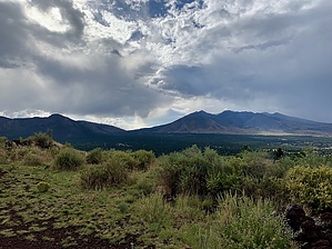
A short climb to some caves by OlenWhitaker   Old Caves Crater trail is a relatively unremarkable trail that leads to the summit of Old Caves Crater where you can find......old caves! The trailhead is easy to find; simply head North from Flagstaff via HWY 89. A mile or two after you leave the city limits you will come to a traffic light at Silver Saddle Rd. Turn right onto Silver Saddle and less than a mile down the road you will find the trailhead parking lot on your left. From the trailhead, the first section of the trail was a road at one time, although it is now closed to all motorized vehicles. Flat, wide, and of shallow grade, the hiking is very easy. This stretch of the trail continues for perhaps a quarter-mile through stands of older (100+ years) Ponderosa pines before taking you to the bottom of a set of switchbacks that will take you up the mountain. Old Caves Crater trail is a relatively unremarkable trail that leads to the summit of Old Caves Crater where you can find......old caves! The trailhead is easy to find; simply head North from Flagstaff via HWY 89. A mile or two after you leave the city limits you will come to a traffic light at Silver Saddle Rd. Turn right onto Silver Saddle and less than a mile down the road you will find the trailhead parking lot on your left. From the trailhead, the first section of the trail was a road at one time, although it is now closed to all motorized vehicles. Flat, wide, and of shallow grade, the hiking is very easy. This stretch of the trail continues for perhaps a quarter-mile through stands of older (100+ years) Ponderosa pines before taking you to the bottom of a set of switchbacks that will take you up the mountain.This second part of the trail is not as wide as the first but is still very easy going and easy to follow. The grade starts fairly shallow and generally increases as you near the summit although it never gets near what I would consider steep. After a few switchbacks that take you up through some scrubby vegetation dotted with pinon pine and a few junipers, the trail will arc around the mountain a short way clockwise before one last push up to the summit ridge. At the summit ridge, you will come to a T intersection. Turning left will take you about 100yds. to the actual summit around 7150ft (NOTE: the round-trip distance listed is to the summit and back.) Turning right will take you a very short distance to the south summit which is dotted with the old caves alluded to in the trail name.
From there you can return the way you came or you can pass over the true summit and continue down the other side where it appeared that the trail connected with a jeep track that might be used as an alternate route back to the trailhead but I can't be sure if the two connect as I did not follow the trail down the Northside, and it does not appear on any map I can find. Note that the first part of the trail is crisscrossed by a zillion jeep tracks and other assorted paths. Most of the intersections have signs to tell you which way is the trail you are trying to follow; a few intersections don't but at no point is it particularly difficult to figure out where to go. Overall the trail is easy and straightforward with little interest and the caves themselves are not much to see. I enjoyed the trip but I wouldn't go far out of my way for it especially since you see, hear, and sometimes smell the city the whole way. See it if you're in the area, just don't make a special trip for it. Check out the Official Route and Triplogs. Leave No Trace and +Add a Triplog after your hike to support this local community. | ||||||||||||||||||||||||||||||||||||||||||||||||||||||||||||||||||||||||||||||||||||||||||||||||||||||||||||||||||||||||||||||||||||||||||||||||||||||||||||||||||||||||||||||||||||||||||||||