Route Editor

| Guide | ♦ | 93 Triplogs | 0 Topics |
details | drive | permit | forecast | route |
stats |
photos | triplogs | topics | location |
| 552 | 93 | 0 |
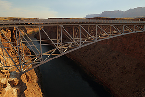
Vermillion view by Randal_Schulhauser  With the Glen Canyon Dam Overlook, and Horseshoe Bend Overlook available as HikeArizona.COM triplogs might as well complete the "hat trick" with a stop at the Marble Canyon Overlook at Navajo Bridge. With the Glen Canyon Dam Overlook, and Horseshoe Bend Overlook available as HikeArizona.COM triplogs might as well complete the "hat trick" with a stop at the Marble Canyon Overlook at Navajo Bridge.The stunning views of Marble Canyon offered from the bridge are not for those with any great fear of heights! If you can brave your vertigo, you will also find views of the Vermillion Cliffs to the north and west along with views of the Echo Cliffs to the south and east. Check along the Vermillion Cliffs for any large birds circling to catch an updraft. They are likely to be California Condors from the Vermillion Cliffs re-introduction. Twenty-Five Condors now call these cliffs home.
When the original bridge was built in 1929, bridge-building regulations were different when compared to modern-day regulations. The original bridge's maximum load capacity (22.5 tons) was not designed to support heavier modern-day vehicles. Both the loads and widths of these modern-day transportation vehicles are a lot larger than the trucks used in 1929. Engineers, in 1929, had no idea that the size of vehicles would increase so drastically, and 18 feet wide seemed more than sufficient for two cars to pass one another in opposite directions. If the engineers wanted to make the bridge any wider than 18 feet in 1929, it would be necessary to add a third arch to the bridge which would have cost more and seemed unnecessary at the time. In 1990, with the new traffic flow, a width of 18 feet was insufficient. Other factors that played a role in deciding to build a new Navajo bridge were the sharp turns on each side of the bridge that decreased visibility and the load limit of the old bridge was not sufficient enough. The posted load limit was 40 tons where the actual load limit should have been 22.5 tons. This is an easy way to stretch your legs if traveling along 89-A. Ponder bridge engineering as you stroll across the bridge! Check out the Official Route and Triplogs. Leave No Trace and +Add a Triplog after your walk/tour to support this local community. | ||||||||||||||||||||||||||||||||||||||||||||||||||||||||||||||||||||||||||||||||||||||||||||||||||||||||||||||||||||||||||||||||||||||||||||||||||||||||||||||||||||||||||||||||||