 Route Editor

| Guide | ♦ | 42 Triplogs | 4 Topics |
details | drive | permit | forecast | 🔥 route |
stats |
photos | triplogs | topics | location |
| 265 | 42 | 4 |
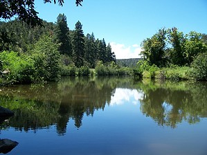
Wild Canyon Exploration by AZHikr4444  Overview OverviewThis 1-2 day backpack appears in the second edition of Grubbs and Aitchison's Hiking Arizona. The book states it is an "8.4-mile hike upstream to Chevelon Canyon Lake" and mentions the "easy" route passing through "beaver ponds, swimming holes, and grassy campsites." My friend Richard and I hiked the canyon the week before the 4th of July. While we found many "easy" sections and quite a few wonderful campsites, TONS of beaver dams, and some absolutely great swimming holes, we also found incredible tangles of willow, wild roses, and other such brush, sheer cliff faces that were necessary to scale, disappearing trails and confusing game routes through swamps along skinny fingers of the winding creek, sections that required some intense boulder hopping, and many tests of our resolve and our increasing vocabulary of curse words. Hike The first 3-4 miles of the hike, from Chevelon Crossing Campground south to Durfee Crossing, is the most enjoyable. Begin by parking at the campground and follow the old jeep road south. Cross the creek immediately and look for the trail as it winds along the creek's south/east side. There are numerous great camping places right here, less than 0.5 miles from the campground. Soon the creek winds slightly west. Along here, you will see the trail follow the contour of the terrain, heading west- although the trail also continues toward the creek. Beware! Take the west trail- the other heads straight into some cliffs, with great views of the canyon, but you must climb these cliffs and come down the other side to continue. How do we know this? Yep. Because we climbed them. If you are on the trail, you will notice a low rock wall blocks this spur.
As the creek begins to wind back south, the trail stays on the east side all the way to Durfee Crossing. Keep an eye out for a picnic table made of logs off to your left, along a jeep road that heads up over the hill. While the trail seems to continue closely following the creek, it's easier to head up the jeep road, follow it back south where it connects with the trail. Also, soon the trail will cliff out at a sheer rock face about 10 feet above the water. Perhaps the trail continues above the cliff. We didn't think so, and besides, it's much more fun to cross here on this one-foot ledge, fingers grasping the rock for dear life. About a mile after Durfee Crossing, powerlines cross high overhead above the creek. Here the going becomes increasingly difficult. The trail will disappear altogether, reappear as game trails winding along the creek bed, become like a mirage on the other side of the creek, flat and easily seen, and then disappear again after monumental efforts to reach it. Expect some great bushwhacking adventures through brambles of willow and New Mexican Locust, along with the ever-present poison ivy, of course. We discovered the rule- stay high! If the trail seems to be easily followed (and there are occasional rock cairns), and then disappears into the creek bed, backtrack and go up above the creek, and the trail can sometimes be retrieved. Perhaps a mile and a half past the power lines, the creek begins to wind slightly westward. Here you should stay on the creek's east side, as the trail is flat and easy. However, soon after the turn, the trail will fade away, and it becomes necessary to cross. Cross the creek and climb the ridge, and the trail will follow the ridge over a very sandy straight drop-off until it levels onto a flat slickrock area. Here you will find an old grave marked with a wooden cross, and further south, an old homesite. This is a very beautiful area of the canyon. There is a large cairn made of flat sandstone around here, almost like a bench. The trail continues, becoming more difficult to follow, and the hiking slows to a crawl. After 9 hours of hiking the canyon, we finally found some scattered campsites on the creek's west side. We plopped down on a sandy beach, ate our dinner, and slept the sleep of the dead. But not before a nice dip in the cold Chevelon waters. It was a beautiful and peaceful night. Richard's lasting impression of this camp was the complete and implacable silence, an almost eerie absence of sound even close to the water. Snuggled in my bag in my hollowed sand bed, I slept perhaps the best night in many a moon, despite my tired bones and aching shoulders. Sad to say, we never made it to the Dam. Although we were only about a mile and a half away, we determined that we could not enjoyably continue at the present rate of speed. We decided to turn back and use our last full day for more slow and lasting pleasures other than bushwhacking, cussing, and blasting through large rodent homes. Knowing what the look for in the trail, the return to Durfee Crossing was much more enjoyable. We hiked a good 4 hours, past the Crossing, to Red Ant Meadows, found a good campsite, and spent the rest of the day sunning ourselves in the meadow, swimming, and generally relaxing. There are literally millions of crawdads in Chevelon Creek, all after your toes, so watch out! One old battle-scarred one-clawed warrior challenged me numerous times to some toe wrestling, but alas, the Creek was his, and I was in no mood for conflict. I opted to bury them in the sand instead and see visions in the clouds above the canyon. The hike out was easy and relaxing, following the well-established trail. There are some great camping areas, and even this close to Chevelon Crossing Campground, there are great swimming holes. We estimated the mileage to be about 15-16 miles roundtrip. I would consider the trip from Chevelon Crossing to Durfee Crossing to be a moderate hike with some occasional route finding. However, south of Durfee Crossing, expect a much more difficult journey, with route-finding skills a definite necessity. Check out the Official Route and Triplogs. Leave No Trace and +Add a Triplog after your hike to support this local community. One-Way Notice This hike is listed as One-Way. When hiking several trails on a single "hike", log it with a generic name that describes the hike. Then link the trails traveled, check out the example. | ||||||||||||||||||||||||||||||||||||||||||||||||||||||||||||||||||||||||||||||||||||||||||||||||||||||||||||||||||||||||||||||||||||||||||||||||||||||||||||||||||||||||||||||||||||||||||||||


