 Route Editor

| Guide | ♦ | 5 Triplogs | 0 Topics |
details | drive | permit | forecast | 🔥 route |
stats |
photos | triplogs | topics | location |
| 64 | 5 | 0 |
Canyons are inherently risky. Flash floods occur without notice on sunny days. Technical skills & surrounding topography knowledge required yet does not eliminate risk.
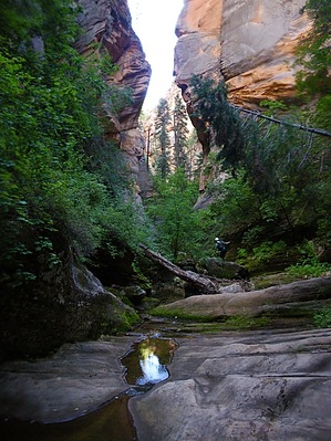
Mossy Mo' by nonot  Overview OverviewA rock hopping trip into the West Fork of Oak Creek, with a single rappel Warning Check the weather to make sure rain isn't predicted. The canyon gets narrow in spots and could flash flood. For this trip, bring 20 ft of webbing, a 40 ft rope, a single rap ring, a harness, wetsuit, helmet, locking biner, and rappelling device.
Published in Todd Martin's book: Arizona: Technical Canyoneering. Hike From the car park just of Woody Mtn Rd, walk east along the old road until you reach the furthest spot most will go. Continue through the fence and walk the road past the tank and through the large meadow filled with thistles. After a while, the rd will split with the better rd heading off northeast under some trees and a vanishing rd going southeast towards the draw. Take the right fork and follow this rd until it reaches the draw and dead ends. Jump in the draw and rock hop downstream, look for good elk trails for the first half mile to avoid the worst of the bushwhacking, but after a while, you will be whacking bushes and climbing over lots and lots of downfall. After about 2 hours, the canyon opens up slightly, and the floor turns into some nicely fluted sandstone. After playing on this for a bit, you will come to a point where the canyon narrows. Put on your wetsuit here. You can bypass the first pool, but after this is a downclimb/slide into a swimmer. The water is surprisingly cold compared to its canyon neighbors. Get out of the pool and splash/wade through a few more as the canyon twists and turns. You will soon come to the only rappel in the canyon of about 15 ft. Though some may want to try to downclimb, I strongly recommend against it due to the slipperiness of the walls. Rappelling is a safer option. And though the pothole below looks keeper-like, it is not. After the one rappel, you will likely want to leave on your wetsuit. There is still three-quarters of a mile to go to the confluence and at least one more swimmer and a few possible waders. At about this point, the moss becomes the canyon's predominant attraction. Those who brought cameras will likely get many good shots of the green moss contrasting against the black basaltic boulders that litter the canyon floor. Continue downcanyon: Rock hop, wade, and crawl over all the deadfall. It narrows down briefly in sections but is not sustained. 800 ft before the confluence is a downclimb into a mandatory swimmer. It is rather cold for those that put away their wetsuits early, but it is an excellent way to cool off. When you finally hit the West Fork, turn right (upcanyon) and rock hop and rock climb (non-tech) up the canyon. **Make sure you take the right turn where West Fork splits into a branch heading northwest and southwest.** The last half-mile of the canyon features a good trail if you can find it. When you hit the bridge of FR231, turn right and hike the road uphill back to your vehicle. Water Sources Nothing you want to drink Camping There are numerous sites near the trailhead and elsewhere off Woody Mtn Rd. Note Spotting a car on Woody Mtn Rd at the West Fork TH will save you 2.8 miles and 1 hr of road walking; subtract this from the stats above.
Check out the Official Route and Triplogs. Leave No Trace and +Add a Triplog after your canyon trip to support this local community. | ||||||||||||||||||||||||||||||||||||||||||||||||||||||||||||||||||||||||||||||||||||||||||||||||||||||||||||||||||||||||||||


