Route Editor

| Guide | ♦ | 22 Triplogs | 0 Topics |
details | drive | no permit | forecast | route |
stats |
photos | triplogs | topics | location |
| 46 | 22 | 0 |
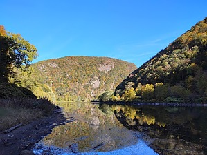
All Boss, No Tweed by Jim The Kittatinny Mountain ridge keeps the Delaware River in its current course, with the breach in the range being the Water Gap. The Gap was to be a dam location with a reservoir behind it, but this was canceled sometime in the late 1960s or early 1970s due to public objection as well as a long-term drought ending.
The hike I describe is a loop using the Red Dot and Blue trails. Access from the first parking lot at Dunnfield Creek trailhead is for the Red Dot Trail, with a short connector trail from the second parking lot. The hike can easily be completed as an out-and-back using either trail, with the Red Dot being the most popular and shortest for this option based on what I observed. The Red Dot Trail is straightforward and marked with a red dot on a white rectangle so the markers resemble a Japanese Flag. The trail is rocky and steep with numerous viewpoints. The most popular viewpoint is the highest one at the junction with the Blue Trail. There really is no summit here, not like I expected, and the "summit" viewpoint is a rocky slope that descends away from the trail towards the river. Continuing along the loop the Red Dot Trail basically turns into the Blue Trail. The Blue Trail is a gentler descent route and most people seem to use it as such. It is also used as an easier ascent route. I found the Blue Trail to be more scenic, due to both the forest and a creek at the bottom with two nice bridge crossings. The lower creek area also seems to attract non-hiking water-seeking tourists. If you want, you can visit what is actually the summit of Mount Tammany by making a short side trip into the forest. It has no views and there may be a tick risk, but you can be one of the few to actually summit and not just hike the loop. Check out the Official Route and Triplogs. Leave No Trace and +Add a Triplog after your hike to support this local community. | |||||||||||||||||||||||||||||||||||||||||||||||||||||||||||||||||||||||||||||||||||||||||||||