History
Previously known as Hieroglyphic Trail. Which has also been rerouted from its original path.
No traditional markers along the trail coupled with parking problems at the North end (see below), is probably why I've only seen two other people in all the times I've ventured on this trail.
This is a great workout hike, similar to the Mormon trail in elevation gain and difficulty.
I'll describe the trail going from South to North. The trail begins at the Buena Vista lookout. Head straight north past the bench (see photo), and look for the trail to veer to the right about 1/4 of a mile from the trailhead. There is only one small marker that is not labeled. The initial descent is steady, and you quickly leave any evidence of civilization behind. At around the halfway mark, you must look for the trail to the right (East), or else you will end up on the spur trail that goes to the Boy Scout Camp property. Take a look at the photos to assist you in making the correct route choice. Once past the fork in the trail, you head through a neat little isolated valley, across a few washes. Once past the second wash, the trail ascends briefly, then starts to head straight down to the Valley floor. There are good views of downtown Phoenix.
The trail passes by a new housing development, then between more houses and the East end of the Boy Scout Camp. The North end of the trailhead is right where Dobbins Road turns North and becomes 20th Street (see photos).
Parking anywhere at the North end of the trail is frustrating. All along Dobbins and 20th street are private driveways, and the new development has several "Parking for residents and guests only" type signs, so I can't recommend that location either. Your best-guaranteed parking space would be at the Mormon trailhead parking lot where 24th Street ends and walking the 1/2 mile along Euclid Avenue to the Geronimo trailhead.
When hiking several trails on a single "hike", log it with a generic name that describes the hike. Then link the trails traveled, check out the example.
WARNING! Hiking and outdoor related sports can be dangerous. Be responsible and prepare for the trip. Study the area you are entering and plan accordingly. Dress for the current and unexpected weather changes. Take plenty of water. Never go alone. Make an itinerary with your plan(s), route(s), destination(s) and expected return time. Give your itinerary to trusted family and/or friends.
Permit $$
None
Directions
Road
Paved - Car Okay
To hike The South End begins at the Buena Vista Parking Lot. The North End begins at the intersection of Dobbins Road and 20th Street.
 Route Editor

 History
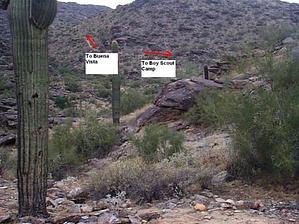


