Overview
Bronco Trail #245 is part of the Tonto National Forest Cave Creek/Seven Springs trail system. It is a moderate hike through the non-riparian parts of this approximately 30-mile trail system. At this elevation, you have left the Saguaro habitat for shrub and chaparral habitat. This area was burned in the Cave Creek Complex Fire in July 2005. Topo: 7.5 Humboldt Mountain.
Hike
The large trailhead has been designed & equipped for equestrians. It has staging corrals and water for horses. The Forest Service maintains the restrooms. This area is a few degrees cooler than Phoenix, but it has very little shade and can be very hot from June through September. Trailhead elevation is 3,700 feet.
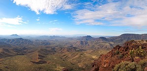
The trail starts as an old jeep trail in a southwesterly direction. It climbs quickly up a small hill (220 feet in 1/2 mile). This old jeep trail meanders along a ridge with great views to the south. At 1.3 miles, the trail narrows as you cross a small grassy saddle. You curve around then along the north side of a hill above a creekbed. At 1.7 miles, you cross the small creekbed and proceed across some grassland. The trail narrows and becomes steeper. You continue up and along the south side of a mountain with views of Skull Mesa and the Tonto National Forest. You reach a saddle at 2.4 miles. This is the highest point on the trail at 4,230 feet. You trek steeply down to a stock tank at 2.6 miles. Look for the trail markers & cairns on the southwest side of this stock tank. I have seen mule deer near this tank. You head up and over a hill west of the stock tank. Then continue mostly downhill. Stay to the right at a small T junction at 3.2 miles. It is well marked. You pass to the north of a stock tank. At 3.7 miles, you reach the "T" junction with Cottonwood Trail #247. Most of the old fence was destroyed by the fire and has not been rebuilt. The trail showed signs of recent maintenance and improvements.
WARNING! Hiking and outdoor related sports can be dangerous. Be responsible and prepare for the trip. Study the area you are entering and plan accordingly. Dress for the current and unexpected weather changes. Take plenty of water. Never go alone. Make an itinerary with your plan(s), route(s), destination(s) and expected return time. Give your itinerary to trusted family and/or friends.
Permit $$
None
Directions
Road
FR / Dirt Road / Gravel - Car Okay
To hike Take the 101 to the Pima Road Exit and head north on Pima Road. At 11.8 miles, you intersect Cave Creek Road. Turn right. At approximately 4 miles, you will come to the Bartlett Lake turnoff. Stay to the left at the turnoff to Bartlett Dam Road. Continue 7.6 miles to the large trailhead on the west side of the road. Cave Creek Road turns into FR 24. The pavement ends 4.5 miles past the Bartlett Dam Road turnoff. The dirt road is passable in a car. A nice ranger from the Forest Service asked me to request that hikers please park at the south end of the trailhead to avoid interfering with equestrian access.
From the north country, drive south on I-17 to exit #223 and head east on the Carefree Highway. Drive approximately 12 miles to the end at a 'T' intersection and turn left on Tom Darlington Dr. Continue north approximately 2 miles until it ends at Cave Creek Rd. Turn right. Drive east on Cave Creek Road approximately seven miles until you come to the Bartlett Lake turnoff. Follow the directions above.
 Route Editor


 Overview