 Route Editor

| Guide | ♦ | 5 Triplogs | 0 Topics |
details | drive | no permit | forecast | route |
stats |
photos | triplogs | topics | location |
| 82 | 5 | 0 |
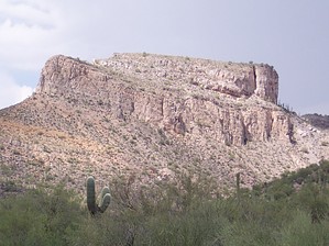
Grazing Mountain Lions by Desrat3635  I grew up in nearby Kearny, so Steamboat Mountain always fascinated me. It is made of limestone - built layer upon layer by an ancient sea. Fossils from various sea creatures can be found in the boulders that have fallen from its cliffs. The mountain is slowly coming apart, as evidenced by some large cracks found on the summit. I grew up in nearby Kearny, so Steamboat Mountain always fascinated me. It is made of limestone - built layer upon layer by an ancient sea. Fossils from various sea creatures can be found in the boulders that have fallen from its cliffs. The mountain is slowly coming apart, as evidenced by some large cracks found on the summit.Steamboat Mountain is part of the Dripping Springs Mountain chain situated on the Pinal/Gila county line. It is in the eastern portion of the Sonoran Desert, and I have seen javelinas, rattlesnakes, a desert tortoise, and even a Gila Monster on its slopes. The area is also home to mountain lions, although I've not personally seen one. Prospectors have thoroughly worked the area, and there are at least two long-abandoned mine shafts near the mountain.
From the top, you get a great view of the Gila River Valley to the south, the Dripping Springs mountain range to the east and west, and the Pinal Mountains to the North. The town of Kearny is visible in the distance, and the smokestack from ASARCO's Hayden smelter can be seen to the east. The wash on the western side of the mountain has a seasonal waterfall, and there are a couple of canyons with springs to the north. These canyons have tall cottonwood trees and very lush vegetation. Check out the Official Route and Triplogs. Leave No Trace and +Add a Triplog after your hike to support this local community. One-Way Notice This hike is listed as One-Way. When hiking several trails on a single "hike", log it with a generic name that describes the hike. Then link the trails traveled, check out the example. | |||||||||||||||||||||||||||||||||||||||||||||||||||||||||||||||||||||||||||||||


