Route Editor

| Guide | ♦ | 82 Triplogs | 2 Topics |
details | drive | no permit | forecast | 🔥 route |
stats |
photos | triplogs | topics | location |
| 942 | 82 | 2 |
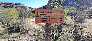
Just some more paradise by sventre  Prologue PrologueThere are several ways to enter Telegraph Canyon. This route beginning at the Picketpost Trailhead parking area is not only one of the easiest -- it is most scenic. As an in-n-out hike, it is not more than 5.5 miles and should be done in the early morning hours if you want the best colors, shadows, and peaceful quiet. If you want to make a "loop" consider either the Picketpost Circumference hike, or exiting the canyon to the east from the point where this description ends and on Perlite Rd past the Town of Pinal historic cite. Hike The hike begins at the trailhead parking area. If you want to have the option of a different entry/exit from the main trail, proceed from the lot in the directions of Picketpost. From there you will head left at the first fork in the trail and climb the rise of rocks and hills as the trail makes its way toward Arnett Creek. Once over the rise, you will see the creek and the steel gate providing entry onto the Arnett Creek Trail. From this point, there is no way to get lost. The trail follows the creekbed and is contained by the canyon walls on either side before turning southeast toward the connection with Telegraph Canyon.
As the trail, creek, and canyon turn south-east the area opens up to a wider span of desert. It remains enclosed on the left by the walls of Arnett Canyon and on the right by foothills of Picketpost Mountain. Much of this area was burned, and while it is recovering, the expansive views can be appreciated. If you make an especial effort you may find the one or two stands of palm trees that yet remain along the canyon wall [to your left] and the creek [to your right]. Today the creek itself was still flowing as a consequence of the rains from a few weeks ago; and, it is at the point along the trail [and as you enter into Telegraph Canyon] the pools of water become more evident. Likewise, desert wildflowers were beginning to appear. Once you have passed through the burn area, you enter the cottonwood forest which is itself an oasis in the desert. The trail remains soft but is interspersed with portions of cobblestone laid years before, and a few sections that cross rock outcroppings. All the while the hike remains easy without any perceivable change in elevation. The remaining few more creek crossings were equally easy, but maybe a bit more problematical when the water levels increase. By this point, you will have covered about 3 miles from the trailhead and reached the trail-marker for exiting the canyon in the direction of Superior, or continuing along the creek toward FR4. Continuing along the trail you will also connect with the fork that enters into Telegraph Canyon. At this point, should you retrace your steps, you may decide to exit the trail by avoiding the gate through which you first passed when seeing Arnett Creek, and, instead remaining along the Creek [right fork] and returning to the Picketpost parking area along the old access route. Gate Policy: If a gate is closed upon arrival, leave it closed after you go through. If it is open, leave it open. Leaving a closed gate open may put cattle in danger. Closing an open gate may cut them off from water. Please be respectful, leave gates as found. The exception is signage on the gate directing you otherwise. Check out the Official Route and Triplogs. Leave No Trace and +Add a Triplog after your hike to support this local community. | |||||||||||||||||||||||||||||||||||||||||||||||||||||||||||||||||||||||||||||||||||||||||||||||||||||||||||||||||||||||||||||||||||||||||||||||||||||||||||||||||||||||||||||||||||||||||||||||||||||||||