|
tap row or icons for details
|
| Difficulty |
|
4 of 5 |
| Route Finding |
|
3 of 5 |
| Distance Round Trip |
|
10 miles |
| Trailhead Elevation |
|
1,414 feet |
| Elevation Gain |
|
1,690 feet |
| Avg Time Round Trip |
|
6-8 hours |
| Kokopelli Seeds |
|
18.45 |
| Interest Peak | | Backpack No | | unreported if dogs are allowed
editedit > ops > dogs to adjust |
| | |
|
|
1 |
2026-01-23 |
|
|
|
8 |
2017-12-31 | Peter_Medal |
|
|
15 |
2013-11-23 |
Peak 3104 via 3010 |
chumley |
|
|
| |
|
|
|
list |
map |
done |
Phoenix Region |
| | |
|
| |
|
|
Historical Weather |
| Trailhead Forecast | | |
|
 |
|
|
| Preferred Feb, Nov, Jan, Mar → 9 AM |
|
|
|
Seasons Late Autumn to Early Spring |
|
|
| | |
| |
Named Locations Coordinate Links
| |
|
|
San Tan Mtns (Gila) Peak 3104
|
9.25 mi
2,123 ft |
 |
| San Tan Mtns (Gila) Peak 3104
|
5.81 mi
1,969 ft |
|
|
| San Tan Mtns (Gila) Peak 3104
|
4.91 mi
1,860 ft |
|
|
| Peak 3104 via 3010
|
5.76 mi
2,158 ft |
|
|
| | |
| |
|
|
NOTICE
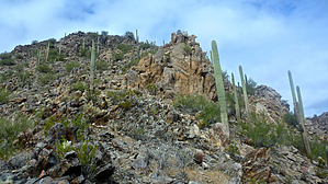
It's impossible to do this hike legally under current conditions. No trespassing signs line the property. One sunny winter Saturday I felt like hiking the Santan Mts to the south of Gilbert. Not the ones near Johnson Ranch with a regional park, but the taller peaks that are actually into the Gila River Indian Reservation. There are no established trails, some old jeeps roads, so bring pants to counter all the cactus. The route I took was from the north near Hunt Highway and Recker Rd. I headed southeast around the base then up to that northern peak of the cluster. As I suspected, the peak to the south of it is even higher. So after a light rest and snack, I headed along the ridgeline to the southern peak. There's an awesome view of the southeastern part of the valley that really can't be found on any other peak because there aren't very many peaks down here. This is a great place to have lunch where you can enjoy the views of Gilbert, Chandler, Queen Creek, South Mountain, and the Estrellas to name a few. Now you can brag to your friends that you've been up a very seldom hiked peak. The best route I'd recommend if you wanted to go straight to the highest peak is to continue SE around the base of the northern peak until you reach a large canyon that opens up. Head back in there towards the southern peak until you hit the rock slide and hike up that. This way you avoid most of the cactus that I was dodging most of the way in. This also ended up being the way I exited, having seen it from above.
Call the Gila River Indian Reservation beforehand to get permission to hike here. If you get caught and arrested, don't say I didn't warn you.
Check out the Triplogs. NoteThis is a moderately difficult hike. |
 Route Editor