| Lookout Mtn Circumference Trail #308
| Official Route |
HAZ_Hikebot |
|
2.7 mi
411 ft |
|
|
|
Lookout Mtn Circumference Trail #308
|
2.92 mi
468 ft |
 |
|
Lookout Mtn Circumference Trail #308
|
3.63 mi
580 ft |
|
|
Lookout Mtn Circumference Trail #308
|
2.74 mi
505 ft |
|
|
Lookout Mtn Circumference Trail #308
|
2.69 mi
564 ft |
|
|
Lookout Mtn Circumference Trail #308
|
3.56 mi
571 ft |
|
| Lookout Mtn Circumference Trail #308
|
3.34 mi
488 ft |
|
|
|
Lookout Mtn Circumference Trail #308
|
7.13 mi
501 ft |
|
|
Lookout Mtn Circumference Trail #308
|
3.68 mi
520 ft |
|
|
Lookout Mtn Circumference Trail #308
|
3.56 mi
656 ft |
|
|
Lookout Mtn Circumference Trail #308
|
3.12 mi
491 ft |
|
|
Lookout Mtn Circumference Trail #308
|
4.03 mi
589 ft |
|
|
Lookout Mtn Circumference Trail #308
|
3.56 mi
521 ft |
|
|
Lookout Mtn Circumference Trail #308
|
4.2 mi
546 ft |
|
|
Lookout Mtn Circumference Trail #308
|
2.37 mi
436 ft |
|
|
Lookout Mtn Circumference Trail #308
|
2.89 mi
517 ft |
|
|
Lookout Mtn Circumference Trail #308
|
3.3 mi
497 ft |
|
|
Lookout Mtn Circumference Trail #308
|
1.94 mi
281 ft |
|
|
Lookout Mtn Circumference Trail #308
|
2.63 mi
289 ft |
|
|
Lookout Mtn Circumference Trail #308
|
2.16 mi
266 ft |
|
|
Lookout Mtn Circumference Trail #308
|
3.33 mi
504 ft |
|
| Lookout Mtn Circumference Trail #308
|
2.78 mi
393 ft |
|
|
|
Lookout Mtn Circumference Trail #308
|
3.58 mi
597 ft |
|
|
Lookout Mtn Circumference Trail #308
|
3.05 mi
433 ft |
|
|
Lookout Mtn Circumference Trail #308
|
4.32 mi
597 ft |
|
|
Lookout Mtn Circumference Trail #308
|
3.47 mi
592 ft |
|
|
Lookout Mtn Circumference Trail #308
|
4.06 mi
556 ft |
|
|
Lookout Mtn Circumference Trail #308
|
3.23 mi
407 ft |
|
|
Lookout Mtn Circumference Trail #308
|
3.49 mi
591 ft |
|
|
Lookout Mtn Circumference Trail #308
|
4.12 mi
550 ft |
|
|
Lookout Mtn Circumference Trail #308
|
2.72 mi
373 ft |
|
|
Lookout Mtn Circumference Trail #308
|
2.9 mi
475 ft |
|
|
Lookout Mtn Circumference Trail #308
|
3.02 mi
492 ft |
|
| Lookout Mtn Circumference Trail #308
|
4.09 mi
626 ft |
|
|
|
Lookout Mtn Circumference Trail #308
|
3.53 mi
460 ft |
|
|
Lookout Mtn Circumference Trail #308
|
4.04 mi
644 ft |
|
|
Lookout Mtn Circumference Trail #308
|
3.34 mi
453 ft |
|
|
Lookout Mtn Circumference Trail #308
|
4.54 mi
739 ft |
|
|
Lookout Mtn Circumference Trail #308
|
3.71 mi
543 ft |
|
|
Lookout Mtn Circumference Trail #308
|
3.57 mi
543 ft |
|
|
Lookout Mtn Circumference Trail #308
|
2.25 mi
352 ft |
|
|
Lookout Mtn Circumference Trail #308
|
3.69 mi
488 ft |
|
|
Lookout Mtn Circumference Trail #308
|
2.87 mi
472 ft |
|
|
Lookout Mtn Circumference Trail #308
|
3.68 mi
542 ft |
|
|
Lookout Mtn Circumference Trail #308
|
2.1 mi
330 ft |
|
|
Lookout Mtn Circumference Trail #308
|
3.54 mi
515 ft |
|
|
Lookout Mtn Circumference Trail #308
|
3.04 mi
510 ft |
|
|
Lookout Mtn Circumference Trail #308
|
3.58 mi
536 ft |
|
|
Lookout Mtn Circumference Trail #308
|
4.64 mi
727 ft |
|
|
Lookout Mtn Circumference Trail #308
|
3.64 mi
536 ft |
|
|
Lookout Mtn Circumference Trail #308
|
3.62 mi
538 ft |
|
|
Lookout Mtn Circumference Trail #308
|
3.07 mi
511 ft |
|
|
Lookout Mtn Circumference Trail #308
|
3.95 mi
558 ft |
|
|
Lookout Mtn Circumference Trail #308
|
2.28 mi
344 ft |
|
|
Lookout Mtn Circumference Trail #308
|
3.61 mi
477 ft |
|
|
Lookout Mtn Circumference Trail #308
|
2.97 mi
433 ft |
|
|
Lookout Mtn Circumference Trail #308
|
3.54 mi
479 ft |
|
|
Lookout Mtn Circumference Trail #308
|
3.45 mi
550 ft |
|
|
Lookout Mtn Circumference Trail #308
|
3.79 mi
575 ft |
|
|
Lookout Mtn Circumference Trail #308
|
4.33 mi
611 ft |
|
|
Lookout Mtn Circumference Trail #308
|
3.96 mi
552 ft |
|
|
Lookout Mtn Circumference Trail #308
|
2.97 mi
451 ft |
|
|
Lookout Mtn Circumference Trail #308
|
3.11 mi
468 ft |
|
|
Lookout Mtn Circumference Trail #308
|
4.99 mi
701 ft |
|
|
Lookout Mtn Circumference Trail #308
|
3.29 mi
505 ft |
|
|
Lookout Mtn Circumference Trail #308
|
3.36 mi
528 ft |
|
|
Lookout Mtn Circumference Trail #308
|
3.04 mi
514 ft |
|
|
Lookout Mtn Circumference Trail #308
|
3.4 mi
466 ft |
|
|
Lookout Mtn Circumference Trail #308
|
3.04 mi
514 ft |
|
|
Lookout Mtn Circumference Trail #308
|
3.89 mi
634 ft |
|
|
Lookout Mtn Circumference Trail #308
|
2.68 mi
434 ft |
|
|
Lookout Mtn Circumference Trail #308
|
2.91 mi
444 ft |
|
|
Lookout Mtn Circumference Trail #308
|
4.07 mi
627 ft |
|
|
Lookout Mtn Circumference Trail #308
|
2.5 mi
369 ft |
|
|
Lookout Mtn Circumference Trail #308
|
5.21 mi
691 ft |
|
|
Lookout Mtn Circumference Trail #308
|
3.86 mi
557 ft |
|
| Lookout Mtn Circumference Trail #308
|
2.23 mi
317 ft |
|
|
|
Lookout Mtn Circumference Trail #308
|
2.35 mi
348 ft |
|
|
Lookout Mtn Circumference Trail #308
|
2.65 mi
441 ft |
|
|
Lookout Mtn Circumference Trail #308
|
3.36 mi
513 ft |
|
|
Lookout Mtn Circumference Trail #308
|
3.55 mi
528 ft |
|
|
Lookout Mtn Circumference Trail #308
|
2.39 mi
375 ft |
|
|
Lookout Mtn Circumference Trail #308
|
2.8 mi
754 ft |
|
|
Lookout Mtn Circumference Trail #308
|
3.24 mi
679 ft |
|
|
Lookout Mtn Circumference Trail #308
|
2.27 mi
395 ft |
|
|
Lookout Mtn Circumference Trail #308
|
2.29 mi
375 ft |
|
|
Lookout Mtn Circumference Trail #308
|
3.46 mi
559 ft |
|
|
Lookout Mtn Circumference Trail #308
|
3.77 mi
628 ft |
|
|
Lookout Mtn Circumference Trail #308
|
2.72 mi
414 ft |
|
|
Lookout Mtn Circumference Trail #308
|
2.77 mi
413 ft |
|
| Lookout Mtn Circumference Trail #308
|
2.87 mi
447 ft |
|
|
|
Lookout Mtn Circumference Trail #308
|
3.09 mi
529 ft |
|
| Lookout Mtn Circumference Trail #308
|
3.09 mi
729 ft |
|
|
|
Lookout Mtn Circumference Trail #308
|
2.99 mi
565 ft |
|
|
Lookout Mtn Circumference Trail #308
|
2.98 mi
480 ft |
|
|
Lookout Mtn Circumference Trail #308
|
3.43 mi
513 ft |
|
|
Lookout Mtn Circumference Trail #308
|
3.02 mi
492 ft |
|
|
Lookout Mtn Circumference Trail #308
|
3.06 mi
525 ft |
|
|
Lookout Mtn Circumference Trail #308
|
1.79 mi
247 ft |
|
|
Lookout Mtn Circumference Trail #308
|
2.87 mi
470 ft |
|
|
Lookout Mtn Circumference Trail #308
|
2.53 mi
483 ft |
|
|
Lookout Mtn Circumference Trail #308
|
2.91 mi
430 ft |
|
|
Lookout Mtn Circumference Trail #308
|
2.53 mi
388 ft |
|
| Lookout Mtn Circumference Trail #308
|
2.23 mi
313 ft |
|
|
|
Lookout Mtn Circumference Trail #308
|
3.04 mi
465 ft |
|
|
Lookout Mtn Circumference Trail #308
|
3.35 mi
476 ft |
|
|
Lookout Mtn Circumference Trail #308
|
3.04 mi
486 ft |
|
|
Lookout Mtn Circumference Trail #308
|
3.01 mi
486 ft |
|
| Lookout Mtn Circumference Trail #308
|
2.68 mi
416 ft |
|
|
| Lookout Mtn Circumference Trail #308
|
2.42 mi
501 ft |
|
|
| Lookout Mtn Circumference Trail #308
|
2.64 mi
406 ft |
|
|
| Lookout Mtn Circumference Trail #308
|
2.75 mi
428 ft |
|
|
| Lookout Mtn Circumference Trail #308
|
3.05 mi
842 ft |
|
|
| Lookout Mtn Circumference Trail #308
|
2.75 mi
427 ft |
|
|
| Lookout Mtn Circumference Trail #308
|
2.98 mi
582 ft |
|
|
| Lookout Mtn Circumference Trail #308
|
2.48 mi
461 ft |
|
|
| Lookout Mtn Circumference Trail #308
|
3.59 mi
801 ft |
|
|
| Lookout Mtn Circumference Trail #308
|
2.85 mi
535 ft |
|
|
| Lookout Mtn Circumference Trail #308
|
3.72 mi
904 ft |
|
|
| Lookout Mtn Circumference Trail #308
|
2.85 mi
429 ft |
|
|
| Lookout Mtn Circumference Trail #308
|
1.37 mi
406 ft |
|
|
| Lookout Mtn Circumference Trail #308
|
2.99 mi
858 ft |
|
|
| Lookout Mtn Circumference Trail #308
|
2.7 mi
741 ft |
|
|
| Lookout Mtn Circumference Trail #308
|
2.25 mi
435 ft |
|
|
| Lookout Mtn Circumference Trail #308
|
3.17 mi
552 ft |
|
|
| Lookout Mtn Circumference Trail #308
|
2.91 mi
489 ft |
|
|
| Lookout Mtn Circumference Trail #308
|
1.82 mi
737 ft |
|
|
| Lookout Mtn Circumference Trail #308
|
2.55 mi
571 ft |
|
|
| Lookout Mtn Circumference Trail #308
|
3.69 mi
547 ft |
|
|
| Lookout Mtn Circumference Trail #308
|
2.96 mi
471 ft |
|
|
| Lookout Mtn Circumference Trail #308
|
2.9 mi
431 ft |
|
|
| Lookout Mtn Circumference Trail #308
|
4.26 mi
754 ft |
|
|
| Lookout Mtn Circumference Trail #308
|
3.69 mi
868 ft |
|
|
| Lookout Mtn Circumference Trail #308
|
2.42 mi
331 ft |
|
|
| Lookout Mtn Circumference Trail #308
|
1.81 mi
596 ft |
|
|
| Lookout Mtn Circumference Trail #308
|
2.29 mi
340 ft |
|
|
 Route Editor


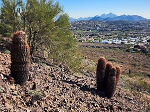
 This trail (and mountain) is located smack dab in the middle of the city, and at times I felt like I was in the middle of nowhere. I only saw about 4 other people, and most were hiking the summit. Peaceful and relaxing, it may not be in my top 10, but it was defiantly worth my time. You'll know you are there when you see the big water tower at the south end of the parking lot. Start near the water tower, and just a few minutes from the trailhead is where 2 trails split. Trail #150 goes up to the summit of Lookout Mountain. The circumference loop continues on trail # 308. Follow the signs. This is a great hike to bring your dog. Be sure to bring enough water, since it is absent on the trail. Saguaros are almost absent here, but there is plenty of desert plant life to remind you of the beauty of the Arizona Desert.