|
tap row or icons for details
|
| Difficulty |
|
0.5 of 5 |
| Distance Round Trip |
|
0.25 miles |
| Trailhead Elevation |
|
5,987 feet |
| Elevation Gain |
|
10 feet |
| Accumulated Gain |
|
10 feet |
| Avg Time Round Trip |
|
0.5 hours |
| Kokopelli Seeds |
|
0.3 |
| Interest Ruins | | Backpack No | |
| | |
|
|
11 |
2015-07-17 | cactuscat |
|
|
10 |
2007-07-07 | Randal_Schulhaus |
|
| |
|
|
|
list |
map |
done |
Alpine Region |
| | |
|
| |
|
|
Historical Weather |
| Trailhead Forecast | | |
|
 |
|
|
| Preferred Apr, Oct, Mar, Nov |
| |
|
|
| | |
| |
Named Locations Coordinate Links
| |
|
| help future hikers |
| post a gps route now |
| | |
| |
|
|
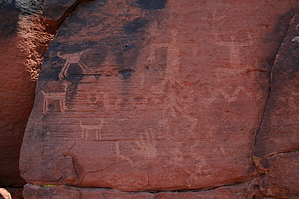
 Rattlesnake Point Pueblo is one of several ancestral Pueblo sites located within Lyman Lake State Park. Lyman Lake was formed by the creation of a dam across the Little Colorado River, just south of Saint Johns. Rattlesnake Point, however, is the only Pueblo village open to the public at the state park. The first stop for a visitor should be at the visitor entrance station/museum where trail guides for Rattlesnake Point, and other trails within the park, are available. Rattlesnake Point is located down on a spur along the shores of Lyman Lake. A paved road leads past yurts and campsites that can be rented out, and then transitions to a good gravel road (this may have been paved since 2003). The road dead-ends at Rattlesnake Point Pueblo in a parking lot. There are no water or bathroom facilities at the site. Water and restrooms are available back at the visitor center. When the lake is at full pool, the site stands out on a peninsula. When I visited in 2003, however, the lake was almost non-existent, so I got to see the land as the Rattlesnake Point dwellers would have seen it - the floodplain of the LCR. The trail is quite brief, taking you around several partially excavated rooms covered with a metal awning. Further exploration of the site is allowed, however, so feel free to walk around exploring the remains of room blocks and the midden. AZ State Parks states:
Stay on the marked trail. Do not climb on prehistoric walls or into excavated rooms. You could easily damage the walls or hurt yourself. It is illegal to damage prehistoric walls or to collect any pottery, stone tools, or other artifacts in the Park. Artifacts found on the ground can be examined and must be returned. Even small potsherds and pieces of stone are useful to archaeologists when left in their original locations. Take plenty of water. You may stay longer than expected. There are no restrooms on the trails. When I visited, there were stone flakes and even some bits of bone (probably from game animals). The site itself isn't too big, so even with exploration and following the basic trail, it doesn't take long to see most of the site. A good combination is the Rattlesnake Point trail, the Petroglyph Point trail, and Casa Malpais in Springerville if you're just in the area for a day. None of the trails take very long, are all somewhat close together, and allow you to get a deeper view into the world of the ancient Pueblo dwellers (especially the little talked-about LCR Puebloans).
AZ State Parks states a little cultural history:
Rattlesnake Point Pueblo was a medium-sized village that was home to about 15 families between AD 1325 and 1390. It was one story tall and had between 80 and 90 rooms. The pueblo was built and occupied by the ancestors of the Hopi, and perhaps other, Pueblo Indian groups. When occupied, the architecture would have resembled that of historic pueblo villages. The pueblo sat on a long ridge overlooking the Little Colorado River. The fertile floodplain along the river was almost certainly farmed by the people living at Rattlesnake Point. Complete trail guide offered in the visitor center. Rooms from this 14th-century ruin can be viewed from a short trail. Tours are available through the Ranger Station on a seasonal basis.
It also seems likely that the Zuni tribe, just over in New Mexico, can trace heritage from Lyman Lake (at least, that's what one archeologist told me back in 2003).
 guide related
|
 Route Editor