Route Editor

| Guide | ♦ | 5 Triplogs | 1 Topic |
details | drive | permit | forecast | map |
stats |
photos | triplogs | topic | location |
| 4 | 5 | 1 |
Canyons are inherently risky. Flash floods occur without notice on sunny days. Technical skills & surrounding topography knowledge required yet does not eliminate risk.
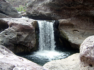
Warm Springs by jkern15674  A beauty with 4 waterfalls within 2 miles and the clearest water in the state. Did I mention that no one knows where this hike is and the area is pristine? After finding out the general locale, I and some technical canyoneer type headed out to see what we could find. The drive is on paved road until that last 2 miles which were fair to good for dirt roads considering the dirt type. After leaving the pavement follow the dirt road around a cow tank (which had 2 dead cows in it) at the water tank on the right hang an immediate left. Follow this road another 1/4 mile until it dead-ends? You will find yourself in the middle of a cholla cactus field thinking there are no canyons here (you can't see any riparian areas, not even a single tree or anything that would give you a clue other than it's on the map) A beauty with 4 waterfalls within 2 miles and the clearest water in the state. Did I mention that no one knows where this hike is and the area is pristine? After finding out the general locale, I and some technical canyoneer type headed out to see what we could find. The drive is on paved road until that last 2 miles which were fair to good for dirt roads considering the dirt type. After leaving the pavement follow the dirt road around a cow tank (which had 2 dead cows in it) at the water tank on the right hang an immediate left. Follow this road another 1/4 mile until it dead-ends? You will find yourself in the middle of a cholla cactus field thinking there are no canyons here (you can't see any riparian areas, not even a single tree or anything that would give you a clue other than it's on the map)From the car park start heading due northeast, this is a boring slog through fields of cacti and cows. After approx 2 miles you should be standing at the edge of the canyon. Now at this point, you have two options: 1. continue hiking north until the canyon curves and there is a butte, at that point, there is an old cable. You can use this as an anchor to rappel off. Now you are probably thinking oh that's an easy way down the 1000ft cliff, but the hard part will be your ascending the rope and trying to keep your hands from becoming a bloody mess. 2. at a rock cairn and several petroglyphs there is a non-tech route down into the canyon. (HINT: the rock cairn is right in front of the waterfall, so if standing at the cliff edge, look straight down at the waterfall and you should be there. I wonder if the Indians planned their petroglyphs that way???) The route down is pretty straight forward and some hand-over-hand work requires class 3-4 scrambling. Once at the creek enjoy the first fall and swimmin' hole. Then start heading downstream to the real fun.
Need: 50ft rope, 50ft pull cord, PAS, harness, beaner', wet or dry suit unless hot, hot, hot, permit from San Carlos Indian reservation Check out the Triplogs. Leave No Trace and +Add a Triplog after your canyon trip to support this local community. | ||||||||||||||||||||||||||||||||||||||||||||||||||||||||||||||||||||||||||||||||||||||||||