Route Editor

| Guide | ♦ | 19 Triplogs | 4 Topics |
details | drive | no permit | forecast | 🔥 route |
stats |
photos | triplogs | topics | location |
| 318 | 19 | 4 |
To pose or not to pose by fricknaley  Off limits? Off limits?Senecio protection area [ map, pdf ] is off limits off-trail unless skiing or snowshoeing on covered snow to protect the San Francisco Peaks groundsel. This hike is not in the protection area. Things may change. Never cross into posted restricted areas. Check with land management before entering. A direct summit of Doyle Peak can be pieced together from another summary on HAZ, which describes various ways to conquer Fremont and Doyle Peaks by Steven. I'm entering this as a more detailed and direct route from the Inner Basin, and also because I took a slightly different route. If you only have time to bag one of these peaks, Doyle is the easier of the two to go after, and it is wicked fun.
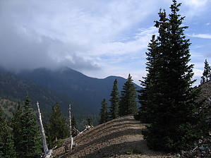
When you finally reach the Inner Basin, it opens up and blows you away. In my opinion, Fremont Peak steals the show. Look all the way to your left, next to the bald-capped Fremont, and you will spot your destination...Doyle Peak. It is rather broad on top and forested, but trust me, it offers great views worth fighting for. As you proceed beyond the deepest reaches of the Inner Basin, the trail climbs straight up into a pine forest and ultimately breaks left at a small sign. This last stretch of the Inner Basin trail is amazing as it briskly switchbacks up and out of the basin. The forestry here is thick and pristine. Moss-covered tree trunks line the way, studded with all sorts of fungi. How amazing! The last leg of the Inner Basin Trail dead-ends at the junction with the Weatherford Trail; this is at roughly 10,750 feet or so. From here, hang a left and follow the Weatherford. You will soon be able to see your first goal, Doyle Saddle, nestled neatly between Doyle and Fremont Peaks. This leg along the Weatherford is spectacular. Is this trail the crown of the Kachina Wilderness? Periodic views down into the Inner Basin are truly amazing and strongly remind one of the views down on Yosemite Valley from the upper reaches of the rims around it...Arizona has it all! The Weatherford occasionally runs through lush pines, and often the trail breaks away and far down to your left with wonderful views. Cross the scree at the mid base of Fremont, and you are getting close. When you finally arrive at Doyle Saddle after almost 1 mile, a small sign announces No Camping between Fremont and Doyle Saddles. There are nice views to the south from here. Doyle is to your left, Fremont to your right. This is where you leave the trail; it's time to scramble up to the summit of Doyle Peak. This will take you about 30-45 minutes, depending on how you climb. There is no clear route; just pick the path of least resistance. There are always a couple of decent options to choose from. Occasionally I saw prints or tracks; far more often, I did not. If you noticed from the Basin, there is an initial peak with a short flat section, then the real summit. So, as you climb, this first level will present itself as a false peak. However, once you reach this, you can see the real summit is very close. From this initial shelf, there are great views south if you hug the right side. If you hug the left from the true summit, there are tremendous views over the Inner Basin, San Francisco Peaks, and especially of neighboring Fremont Peak. This summit is rather flat and forested but truly awesome nonetheless. To get back head towards Fremont Peak, you will not be able to see the saddle initially. Fremont is a good locator beacon until you can lay eyes on the saddle below and head straight for it. Going down is a very quick trip. Have fun.
Check out the Official Route and Triplogs. Note This is a moderately difficult hike. Leave No Trace and +Add a Triplog after your hike to support this local community. | ||||||||||||||||||||||||||||||||||||||||||||||||||||||||||||||||||||||||||||||||||||||||||||||||||||||||||||||||||||||||||||||||||||||||||||||||||||||||||||||||||||||||||||||||||||||||||||||||||||||||||