|
tap row or icons for details
|
| Difficulty |
|
1 of 5 |
| Route Finding |
|
2 of 5 |
| Distance One Way |
|
1 mile |
| Trailhead Elevation |
|
7,000 feet |
| Elevation Gain |
|
200 feet |
| Accumulated Gain |
|
200 feet |
| Avg Time One Way |
|
1 hour |
| Kokopelli Seeds |
|
1.67 |
| Backpack Yes | | unreported if dogs are allowed
editedit > ops > dogs to adjust |
| | |
|
|
15 |
2015-05-24 |
Natanes Mountains |
chumley |
|
|
|
25 |
2007-07-29 | Randal_Schulhaus |
|
|
26 |
2006-10-13 | aaronhales |
|
| |
|
|
|
list |
map |
done |
Alpine Region |
| | |
|
| |
|
|
Historical Weather |
| Trailhead Forecast | | |
|
 |
|
|
| Preferred Oct, May, Apr, Sep → 8 AM |
|
|
| | |
| |
Named Locations Coordinate Links
| |
|
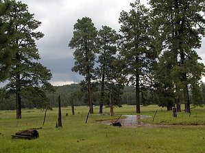
| Dry Lake/Nantac Rim
| 2007-08-05 |
Randal_Schulhauser |
|
123.48 mi
6,393 ft |
|
|
| | |
| |
|
|
 Vast, pristine, and seldom-visited. That's how I'd describe the area of the Nantac Rim east of Globe on the San Carlos Indian Reservation. Having seen this area on my topo maps and identifying it as probably the most significant escarpment besides the Mogollon Rim in Arizona, I figured this would be an interesting area to visit. I was right. Rising an abrupt 2000 feet, the top of the Rim provides a lush, stark contrast to the plains below. My particular destination today was the Dry Lake area on top of the Rim. The access road to this area off the well-graded gravel road to the Point of Pines lake is definitely a high clearance experience. Although 4x4 would be preferred, my 2WD 4-Runner did just fine (and it was even raining heavily). As you can see from the photos, Dry Lake was anything but dry... in fact, it's rarely ever dry and well stocked with fish from what I hear. I had attempted to hike to the edge of the Rim from the Dry Lake area but was running out of daylight to make the complete trip. Alas, it will have to wait for another time. However due to the rainstorms that day, there was a torrent of water EVERYWHERE that was quite spectacular. Be sure on your way out (or way in) to make a small detour to the Dry Lake lookout tower. The views from there are expansive!
Besides the views, one interesting thing to note on your ascent of the Rim is a small Indian ruin on the left side of the road. You can find this ruin by stopping at the second scenic view pull-out and walking up the road 50 feet. It'll be on your left. One-Way NoticeThis hike is listed as One-Way. When hiking several trails on a single "hike", log it with a generic name that describes the hike. Then link the trails traveled, check out the example. |
 Route Editor


