Route Editor

| Guide | ♦ | 12 Triplogs | 0 Topics |
details | drive | no permit | forecast | route |
stats |
photos | triplogs | topics | location |
| 127 | 12 | 0 |
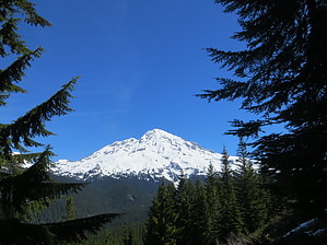
This moderate loop trail passes through forests and offers top vistas. Also known as "The Ramparts," this ridge is the remnant of an ancient lava flow which originated at the summit of Mount Rainier. To connect with the trailhead to Rampart Ridge, begin at the west end of the Trail of the Shadows Trail located across the road from the National Park Inn. The loop can be hiked in either direction, but going clockwise keeps Mount Rainier in front more of the time and is thus recommended. The hike begins steeply as the trail leads through dense forest to the top of the ridge. Once on the ridgetop, it is 1.3 miles of relatively level hiking before starting the descent along the Wonderland Trail back to Longmire.
Along the Trail Walk through an old growth forest as you make your way to the top of Rampart Ridge. At 1.8 miles, there is a view point looking up the Nisqually River Valley. Listen for the tapping of the woodpeckers or the booming of the grouse. Keep an eye out for deer and other wildlife. Notice the various mosses and lichen clinging to the trees. On a clear day, hikers are also rewarded with excellent views of Mount Rainier and the Nisqually River Valley from two viewpoints atop the ridge. At 2.9 miles, join the Wonderland Trail for the return to Longmire. Backpacking There is no designated camp along this trail nor atop Rampart Ridge. Permits are required for camping. Permits and current trail conditions are available at park-wide from wilderness information centers, ranger stations, and visitor centers. Treat water before drinking. Fires are prohibited. No pets on trails. Check out the Official Route and Triplogs. Leave No Trace and +Add a Triplog after your hike to support this local community. | ||||||||||||||||||||||||||||||||||||||||||||||||||||||||||||||||||||||||||||||||||||||||||||||||||||||||||||||||||||||||||||||||||||||||||||||||||||||||||||||||||||||