Route Editor

| Guide | ♦ | 39 Triplogs | 0 Topics |
details | drive | permit | forecast | route |
stats |
photos | triplogs | topics | location |
| 212 | 39 | 0 |
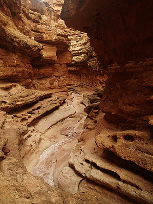
Wash and Dry by nonot   Overview OverviewA hike down a nontechnical wash with a slight bit of scrambling, to the Colorado River and back. Warning The narrow portion of this wash would be dangerous during or shortly after any rains - beware of flash floods and check the weather before departing.
History Cathedral Wash is one of the very few places people can reach the Colorado River down a canyon without requiring rope or other technical means. Hike From your parking spot, find the well-worn trail leading into the bottom of the canyon. Begin descending downhill. It is fairly level at first and you can observe how the wash has cut through a few different geologic layers. As the wash narrows, you will have to perform some easy downclimbs. No moves required to complete the canyon are that difficult, so if you find yourself attempting something you think is dangerous - try to find a better way. After another fairly flat stretch, the wash narrows up again and will descend a few drops. Look for cairns on ledges on either side of the main wash. You will generally be 5 feet above the wash on one side or another. You will reach a major drop in the wash of about 30 ft, the only obstacle of real significance on this hike. Find the trail that contours around it to the right (looking downstream) and go under the overhanging section - watch your head! From here continue on the ledges alternating on sides of the wash when it seems appropriate. A few maneuvers are required to get down - nothing was exposed or more than 3 feet high. When the wash widens you will begin to hear the river. Follow the gravel streambed the rest of the way to the river. Spend a little time and enjoy the view. Return the way you came. Note: If you get muddy on the way down you can wash much of it out in the river - beware that you can get it off the skin but it won't completely come out of clothes, gear, or shoes - it's nasty stuff! Water Sources Colorado River, although the hike is so short you will probably bring 1-2 liters of water. Camping Nearby at Lee's Ferry with a permit. If one obtains a permit, camping may be possible at the beach at the end of the wash. I didn't observe any quality sites and doubt this is a popular option. Check out the Official Route and Triplogs. Leave No Trace and +Add a Triplog after your hike to support this local community. | ||||||||||||||||||||||||||||||||||||||||||||||||||||||||||||||||||||||||||||||||||||||||||||||||||||||||||||||||||||||||||||||||||||||||||||||||||||||||||||||||||||||||||||||||