Turks Head is a great hike to build stamina for future treks in the Superstitions and other local peaks. About half the difficulty of Picketpost and a quarter the difficulty of Carney Springs or the Flatiron. The trail can be accessed from the Hieroglyphics Trailhead or the Lost Goldmine Trailhead at Peralta Road just south of the Peralta Trailhead on the West side of Peralta Road. Roundtrip distance is about 1 mile less from the Hieroglyphics Trailhead.
The peak known locally as Turks Head is located along the Lost Goldmine Trail #60 about 2 1/2 miles east of the Hieroglyphics Trail #101. The Lost Goldmine Trail offers some wonderful rolling views of the Superstition foothills and beauty of the unspoiled Sonoran Desert. Elevations fluctuate as you proceed east, giving you ample warm-up. Just before the towering Turks Head, which is on your left, you will arrive at an old jeep road. Proceed to the north on this old jeep road 1/4 mile. At this point, proceed up a drainage wash to the east and up the mountain known as Turks Head.
There is a trail in spots, but this is mainly a bushwhack with no right or wrong way to get to the top. As you ascend to the east and slightly to the north, you will observe a large balanced rock. At this point, upward and toward the southeast, you will start to pick up cairns. Follow the cairns or blaze your way over at least three false tops to the very peak for some outstanding views of the valley below to the south and east and the future challenges behind you to the north, Carney Springs, The Superstition Ridgeline, on over to the Flat Iron.
Turks Head GPS Coordinates base N33 23.494 W111 24.191 peak N33 23.434 W111 23.788
When hiking several trails on a single "hike", log it with a generic name that describes the hike. Then link the trails traveled, check out the example.
WARNING! Hiking and outdoor related sports can be dangerous. Be responsible and prepare for the trip. Study the area you are entering and plan accordingly. Dress for the current and unexpected weather changes. Take plenty of water. Never go alone. Make an itinerary with your plan(s), route(s), destination(s) and expected return time. Give your itinerary to trusted family and/or friends.
Permit $$
None
Directions
Road
Paved - Car Okay
To Lost Goldmine Trailhead 7.6 miles east of the junction Idaho Rd / US-60. Turn Left on to FS77 which is Peralta Road. Follow FS77 5.6 miles to a left and up turnoff. Continue 1.4 miles to the Goldmine Trailhead, turn in left. There's enough parking for a small army. Restrooms are 0.5 miles up the road at Peralta Trailhead.
From PHX (I-10 & AZ-51) 47.1 mi - about 1 hour 10 mins From TUC (Jct 1-10 & Grant) 96.6 mi - about 2 hours 15 mins From FLG (Jct I-17 & I-40) 191 mi - about 3 hours 13 mins
 Route Editor

 Turks Head is a great hike to build stamina for future treks in the Superstitions and other local peaks. About half the difficulty of Picketpost and a quarter the difficulty of Carney Springs or the Flatiron. The trail can be accessed from the Hieroglyphics Trailhead or the Lost Goldmine Trailhead at Peralta Road just south of the Peralta Trailhead on the West side of Peralta Road. Roundtrip distance is about 1 mile less from the Hieroglyphics Trailhead.
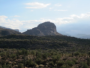


