When hiking several trails on a single "hike", log it with a generic name that describes the hike. Then link the trails traveled, check out the example.
WARNING! Hiking and outdoor related sports can be dangerous. Be responsible and prepare for the trip. Study the area you are entering and plan accordingly. Dress for the current and unexpected weather changes. Take plenty of water. Never go alone. Make an itinerary with your plan(s), route(s), destination(s) and expected return time. Give your itinerary to trusted family and/or friends.
Permit $$
None
Directions
Road
FR / Dirt Road / Gravel - Car Okay
To Lost Goldmine Trailhead 7.6 miles east of the junction Idaho Rd / US-60. Turn Left on to FS77 which is Peralta Road. Follow FS77 5.6 miles to a left and up turnoff. Continue 1.4 miles to the Goldmine Trailhead, turn in left. There's enough parking for a small army. Restrooms are 0.5 miles up the road at Peralta Trailhead.
From PHX (I-10 & AZ-51) 47.1 mi - about 1 hour 10 mins From TUC (Jct 1-10 & Grant) 96.6 mi - about 2 hours 15 mins From FLG (Jct I-17 & I-40) 191 mi - about 3 hours 13 mins
 Route Editor

 2026-03-06 Cloudview to Jacobs is closed due to a private property dispute. STAY OUT!
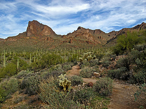


