Route Editor

| Guide | ♦ | 5 Triplogs | 1 Topic |
details | drive | no permit | forecast | map |
stats |
photos | triplogs | topic | location |
| 53 | 5 | 1 |
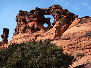
Two for the work of one by PaleoRob   Double-Barrel Arch may not be this arch's "official" name, but it suits it well. Double-Barrel Arch is located along a break in the western Paria Plateau, just south of the northernmost AZT trailhead, and just a quarter-mile up BLM Road 1065 from the West Bench Pueblo turnoff. Looking to the east, just past the West Bench turnoff, you'll notice the plateau begin to flatten out, and then an island of slickrock appears. Look closely at the south end of the escarpment. As you drive a little further north, you'll notice a totem-pole-like spire on the south end of the island. The arch is just north of the totem pole - you'll be able to see it from the road. Park opposite the arch where HRVR crosses a small wash - there's a wide spot off to the west side of the road. There's no real trail, per se, to follow to the arch. The easiest way seems to be to follow the small wash's north bank across the low sage plain, heading directly for the arch. The view from the plain is spectacular, however - you can look north along the west side of the Paria Plateau, and further north you can even see the Aquarius Plateau, way up into Utah. In between, you and the arch lay a low ridge covered in pinon and juniper. Immediately before this ridge is a deep (15+ feet) arroyo. The arroyo is probably the most difficult part of the hike (not saying much, eh?). If you are following the north side of the small wash, your best bet for crossing the arroyo is to hike a short distance to the north, where a small spur arroyo is beginning, and hike down into the main arroyo from there. If you hike a little more north in the arroyo bottom, you should come across a few cattle trails leading up and out of the gully and onto the east side. Find the south side of the sandstone mound again (the arch isn't visible from here), and continue hiking east towards the southern tip. Keep your eyes peeled for Anasazi artifacts - I saw lots of flint flakes and some potsherds when I went. There's also lots of cryptobiotic soil in the P/J area, so watch your step and tread lightly. There are a couple of old cattle paths through the strip of woods that'll keep you off the cryptos. Double-Barrel Arch may not be this arch's "official" name, but it suits it well. Double-Barrel Arch is located along a break in the western Paria Plateau, just south of the northernmost AZT trailhead, and just a quarter-mile up BLM Road 1065 from the West Bench Pueblo turnoff. Looking to the east, just past the West Bench turnoff, you'll notice the plateau begin to flatten out, and then an island of slickrock appears. Look closely at the south end of the escarpment. As you drive a little further north, you'll notice a totem-pole-like spire on the south end of the island. The arch is just north of the totem pole - you'll be able to see it from the road. Park opposite the arch where HRVR crosses a small wash - there's a wide spot off to the west side of the road. There's no real trail, per se, to follow to the arch. The easiest way seems to be to follow the small wash's north bank across the low sage plain, heading directly for the arch. The view from the plain is spectacular, however - you can look north along the west side of the Paria Plateau, and further north you can even see the Aquarius Plateau, way up into Utah. In between, you and the arch lay a low ridge covered in pinon and juniper. Immediately before this ridge is a deep (15+ feet) arroyo. The arroyo is probably the most difficult part of the hike (not saying much, eh?). If you are following the north side of the small wash, your best bet for crossing the arroyo is to hike a short distance to the north, where a small spur arroyo is beginning, and hike down into the main arroyo from there. If you hike a little more north in the arroyo bottom, you should come across a few cattle trails leading up and out of the gully and onto the east side. Find the south side of the sandstone mound again (the arch isn't visible from here), and continue hiking east towards the southern tip. Keep your eyes peeled for Anasazi artifacts - I saw lots of flint flakes and some potsherds when I went. There's also lots of cryptobiotic soil in the P/J area, so watch your step and tread lightly. There are a couple of old cattle paths through the strip of woods that'll keep you off the cryptos.The sand reaches the sandstone suddenly. Follow the southern end of the sandstone up towards the ridge on the sand. You should be able to see the arch again, now that you've broken free of the trees. There's a few spots of slickrock that poke through the sand, but climbing over/around them is no challenge. Once you reach the ridgetop, duck behind the small pine next to the sandstone, and follow a ledge that starts there up a short slickrock draw, use boulders as steps to easily climb up a small ledge, and there you are! The arch-within-an-arch is protected by a hanging claw of rock, suspended as the top half of an arch that is no longer. The tallest arch isn't huge, maybe ten feet tall or so, but the unusual composition of the stone - faulted and swirled sandstone - makes the place seem surreal. There are a few names etched in the abutments of the arch. Members of Powell's second expedition traveled this valley in the late 1800's - perhaps some of the almost-effaced names and dates are theirs! After enjoying the views and exploring, return to your vehicle the way you came. Check out the Triplogs. Leave No Trace and +Add a Triplog after your hike to support this local community. | ||||||||||||||||||||||||||||||||||||||||||||||||||||||||||||||||||||||||||||||||||||||||||