 Route Editor

| Guide | ♦ | 55 Triplogs | 2 Topics |
details | drive | no permit | forecast | 🔥 route |
stats |
photos | triplogs | topics | location |
| 661 | 55 | 2 |
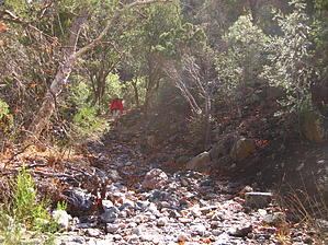
Gamble With Paradise by AZLOT69  FR 287A is a single-lane dirt track in fair condition. We stashed our mountain bikes at the trailhead for Trail 203 (the upper terminus of the Haunted Canyon Loop) then continued on approximately 1.8 miles to the trailhead for Paradise Trail 271. The trailhead has parking for several cars (we saw no cars or hikers the whole day) but is poorly marked. The trailhead signage is located 100 ft up a bare earth hill and is not visible from the road. Without GPS we may not have located the trail as quickly. FR 287A is a single-lane dirt track in fair condition. We stashed our mountain bikes at the trailhead for Trail 203 (the upper terminus of the Haunted Canyon Loop) then continued on approximately 1.8 miles to the trailhead for Paradise Trail 271. The trailhead has parking for several cars (we saw no cars or hikers the whole day) but is poorly marked. The trailhead signage is located 100 ft up a bare earth hill and is not visible from the road. Without GPS we may not have located the trail as quickly.We loaded up and almost immediately entered a wonderful, refreshing environment with rich black soil, tree leaves covering the ground like a mid-fall day in New England, and with the smell of peat as if we had been transported to a different part of the United States. The trail was very easy to follow being broad and generally flat as it switched back and forth across the stream. The hike was one of the quietest hikes I've ever been on; no human sounds, no gravel/rocks under our feet, no distant sounds of aircraft or autos. It was almost quiet enough to hear your heart beating. We found plenty of flowing water in sections of the streambed. The first 1 1/4 miles are an easy stroll with a gain of 400 ft elevation. As we reached the upper end of Trail 271 we broke more and more above the tree line, the vegetation changes more to higher altitude desert growth, and the soil yielded to the typical Arizona gravel. The rate of gaining elevation increased to a more typical climb. We found snow from a storm a week earlier and had some mischief with it. We wonder how long the "snow-cairns" will last.
The downhill trail seemed to be the steepest terrain of the day but no big deal. As we descended the gravel gave way to improving moist soil and again we entered a world of quiet. Less water was in this stream bed. The last mile of the trail is almost level and is easy, smooth, and again the smell of northern woods. Our mountain bikes were pulled from the stash and be coasted downhill the final 1.8 miles to our truck. This is truly a unique hike taking you into a lush environment not easily found in the southwest. The quiet is awesome! There is plenty of time spent above the tree line to view these mountains and rock features in a more remote section of the Superstitions. Check out the Official Route and Triplogs. Leave No Trace and +Add a Triplog after your hike to support this local community. One-Way Notice This hike is listed as One-Way. When hiking several trails on a single "hike", log it with a generic name that describes the hike. Then link the trails traveled, check out the example. | ||||||||||||||||||||||||||||||||||||||||||||||||||||||||||||||||||||||||||||||||||||||||||||||||||||||||||||||||||||||||||||||||||||||||||||||||||||||||||||||||||||||||||||||||||||||||||||||||||||||||||||||||||


