Route Editor

| Guide | ♦ | 23 Triplogs | 0 Topics |
details | drive | permit | forecast | map |
stats |
photos | triplogs | topics | location |
| 201 | 23 | 0 |
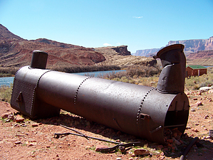
A slice of historic AZ by PaleoRob   The Lee's Ferry River Trail is an easy way to step back into Arizona's historic pioneer past. Located at a bend in the Colorado River where Glen Canyon ends and the Grand Canyon begins, Lee's Ferry offered the only reasonable crossing of the Colorado River between Dandy Crossing (near Hite) and below Grand Canyon (though there were occasional crossings in other spots, such as Dominguez and Escalante's "Crossing of the Fathers"). Lee's Ferry gets its name from John Doyle Lee, the first operator of the crossing. Exiled from Utah by Brigham Young for his involvement in the Mountain Meadows Massacre of eastern settlers, Lee and his first wife, Emma, came to the "Lonely Dell" where they farmed and scratched out a meager living ferrying the occasional traveler across the Colorado River. Among the notables who stopped at Lee's Ferry were J.W. Powell, during his second Colorado trip, and Jacob Hamblin, a Mormon missionary to the Navajos, Piutes, and Hopis. The Ferry was also an essential stop along the famed "Honeymoon Trail," by which Mormon couples set to be wed in the St. George temple would make the long trip from their settlements in Northern Arizona along the Little Colorado River. The Lee's Ferry River Trail is an easy way to step back into Arizona's historic pioneer past. Located at a bend in the Colorado River where Glen Canyon ends and the Grand Canyon begins, Lee's Ferry offered the only reasonable crossing of the Colorado River between Dandy Crossing (near Hite) and below Grand Canyon (though there were occasional crossings in other spots, such as Dominguez and Escalante's "Crossing of the Fathers"). Lee's Ferry gets its name from John Doyle Lee, the first operator of the crossing. Exiled from Utah by Brigham Young for his involvement in the Mountain Meadows Massacre of eastern settlers, Lee and his first wife, Emma, came to the "Lonely Dell" where they farmed and scratched out a meager living ferrying the occasional traveler across the Colorado River. Among the notables who stopped at Lee's Ferry were J.W. Powell, during his second Colorado trip, and Jacob Hamblin, a Mormon missionary to the Navajos, Piutes, and Hopis. The Ferry was also an essential stop along the famed "Honeymoon Trail," by which Mormon couples set to be wed in the St. George temple would make the long trip from their settlements in Northern Arizona along the Little Colorado River.Lee wasn't the only person to attempt to make money from the vicinity of the Ferry. Charles Spencer was a man with a dream to mine gold out of the Chinle Formation's shales using mechanical separation of the gold from the matrix with a coal-fired steam-powered separator. To bring coal for his mining operation, Spencer commissioned a paddle-wheel steamer, the largest boat on the Colorado north of Black Canyon, to bring coal from his mine in Warm Creek, some 25 miles upstream. The transportation of the coal proved to be so inefficient, with the boat needing almost a full load of coal to complete a round trip (and often grounding in the process), and the gold in the Chinle too fine to mechanically extract that when the steamboat (grandiosely named the "Charles H. Spencer") sunk in a few feet of water near the Ferry, the whole operation was abandoned. Other miners also attempted to make their fortune out of the Chinle in the 1950s during the Uranium boom. Still, the ore was not as concentrated at the Ferry as it was in other places across the Colorado Plateau, and very little ore was ever removed before the claims were abandoned. The Ferry, however, continued to operate until the 1920s, when the Navajo Bridge, a few miles downstream, made the ferry crossing obsolete. On the last run of the Ferry, however, it capsized, killing several of its final passengers, as though to underscore the difficulties of crossing the Colorado River by ferry.
The hike itself is fairly easy, though occasionally buggy during warmer months. From the gravel parking area, walk across the chained-off bus parking area towards some old buildings. This is where buses arrive to pick up passengers from float trips coming down the Colorado River from the dam. The old buildings are the remains of a fort, built to protect the Ferry from a band of Navajos who were marauding through the area, though the ferry itself was never attacked. After the buildings, the trail becomes easy to follow, with a few signs to point you in the correct direction in spots where it seems ambiguous. The trail passes by an old steam boiler with an interpretive sign nearby - the remains of Spencer's gold extractor. There is also a picture of Robert Stanton's party eating at Lee's Ferry Fort on Christmas. Stanton was scouting a railroad route through the Colorado River Corridor, a trip that would ultimately end in tragedy not long after leaving Lee's Ferry. Further along, the trail divides, with the Spencer Trail taking off towards the left. There is a sign at the divide to keep right. Not long after this, if you look down towards the river, you can see the boiler and sunken remains of the ill-fated "Charles H. Spencer" still sitting in the river where it sank. The trail continues winding down along the river, crossing over a few small gullies, until it reaches a broad, flat area with a few dead cottonwood trees and the remains of some small buildings. These are the old Ferry buildings, where patrons and operators would wait for customers or the ferry to return. On the ground in a few places around this area are sections of huge cables - the remains of the Ferry's guide cable. The remains of the old trail that originally led away from the Ferry on the south side of the river can be seen across the river. The trail can be followed a little further upstream but eventually comes to an end against a sheer cliff. Turn around, and make your way back to the parking area. There are restrooms and water available there. Check out the Triplogs. Leave No Trace and +Add a Triplog after your hike to support this local community. | |||||||||||||||||||||||||||||||||||||||||||||||||||||||||||||||||||||||||||||||||||||||||||||||||||||||||||||||||||||||||||||||||||||||||||||||||||||||||||||||||||