This loop hike within Mt. Rainier National Park provides great views of the mountain, its glaciers, and surrounding peaks as well. The trail starts at the visitor center at Paradise. Get there early in the summer months to find a parking space and avoid the crowds. The fall season, on the other hand, provides smaller crowds, less snow on the trails, and beautiful colors. I prefer to hike this loop in a clockwise fashion.
From the visitor center, the first part of the trail is paved and climbs steeply. There are several side trails along the route but each intersection is marked so route finding is a breeze. You can pick up a map of the Paradise area trails at the visitor's center or online.
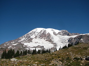
From the start, you're treated to great views of Mt. Rainier. Chances to see wildlife abound along the trail. Grouse, deer, chipmunks, and marmots are all common sights along the trail. At Panorama Point (6,800ft), there is a nice spot for lunch and even a bathroom (open during the summer months). On clear days you can see Mt. Adams, Mt. Hood and Mt. St. Helens from this vantage point. From here the trail crosses a steep patch of snow (almost always present). Be careful crossing this snowfield. to avoid the snowfield, take the Skyline High Trail up from Panorama Point for even closer views of Mt. Rainier. Even if you're comfortable, this side trail only adds .8 miles to your total and the views more than makeup for mileage. After hooking back up with the Skyline trail, continue down the mountain, making sure to look back and enjoy the views behind you. The trail continues down the mountain through beautiful alpine meadows. Non-stop views along the trail will keep you coming back. Summer is great for wildflowers and autumn brings bright reds and oranges. As mentioned, the Paradise area offers several crisscrossing trails so it's easy to mix and match routes to make a custom hike to your liking.
WARNING! Hiking and outdoor related sports can be dangerous. Be responsible and prepare for the trip. Study the area you are entering and plan accordingly. Dress for the current and unexpected weather changes. Take plenty of water. Never go alone. Make an itinerary with your plan(s), route(s), destination(s) and expected return time. Give your itinerary to trusted family and/or friends.
Permit $$
NPS
Directions
Road
Paved - Car Okay
To hike From Portland, take I-5 North to US-12. Head East on 12 toward Morton. At Morton, turn North on WA-7. At the intersection with SR-706, head East and follow this road into the park. Follow this road all the way to Paradise.
 Route Editor