username
X
password
register
for free!
help
  This is likely a great time to hike this trail!  Check out "Preferred" months below, keep in mind this is an estimate.
  🔥

Rock Crossing Trail #18B - Blue Ridge, AZ

Guide 15 Triplogs  0 Topics
  3.6 of 5  
Fav
Wish
2
details
drive
no permit
forecast
🔥
route  
stats
photos
triplogs
topics
location
20 15 0
Statistics
tap row or icons for details
Difficulty 1 of 5
Route Finding 1 of 5
Distance One Way 1.4 miles
Trailhead Elevation 6,720 feet
Elevation Gain 377 feet
Accumulated Gain 389 feet
Kokopelli Seeds 2.7
 Interest Perennial Creek
feature photo
Photos Viewed All MineFollowing
Will recalculate on button tap!
8  2025-06-28
Rock Crossing
trekkin_gecko
8  2025-06-28
Rock Crossing
johnlp
2  2025-06-25
Rock Crossing Trail #18A - Blue Ridge
trekkin_gecko
4  2025-06-25
Rock Crossing Trail #18A - Blue Ridge
johnlp
7  2023-05-20
Blue Ridge Reservoir - CC Cragin
chumley
17  2022-05-14
Long - Bear - Quien - Houston - Rock Crossing
The_Eagle
16  2022-05-14
Cragin canyons
chumley
13  2021-08-07
Tour de Blue Ridge
The_Eagle
Page 1,  2
Author
author avatar Guides 16,843
Routes 17,472
Photos 24
Trips 1 map ( 6 miles )
Age 28 Male Gender
Location HAZ, TrailDEX
Associated Areas
list map done
Payson Region
Historical Weather
Trailhead Forecast
Radar Map
Expand Map
Preferred May, Oct, Sep, Apr
Sun  6:00am - 6:47pm
Official Route & 1 Rt
 
5 Alternative
 
Historic Fire Perimetersacres
🔥 2015 General Fire2.7k
🔥 2010 Ranger Fire2.1k
🔥 2009 July 4th Complex Fire3.1k
🔥 View (All) - over Official Route 🔥


  Likely In-Season!
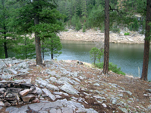
Rock Crossing Trail #18 is split into three segments because it crosses Blue Ridge / C.C. Cragin Reservoir two times.


Segment #18B technically begins on the north arm of the lake, ascends Battleground Ridge, crossing FR123 at the pumping station, before descending to the south arm of the lake. However, most people access the trail from its mid-point at FR123 and hike to either one arm of the lake or the other.
remove free decal offer
See also Segment #18A

See also Segment #18C

2018-07-14 HAZ_Hikebot


    Check out the Official Route and Triplogs.
    Leave No Trace and +Add a Triplog after your hike to support this local community.

    One-Way Notice
    This hike is listed as One-Way.

    When hiking several trails on a single "hike", log it with a generic name that describes the hike. Then link the trails traveled, check out the example.
    WARNING! Hiking and outdoor related sports can be dangerous. Be responsible and prepare for the trip. Study the area you are entering and plan accordingly. Dress for the current and unexpected weather changes. Take plenty of water. Never go alone. Make an itinerary with your plan(s), route(s), destination(s) and expected return time. Give your itinerary to trusted family and/or friends.

     Permit $$
    no fees or permits reported

    if incorrect tell us about it


     Directions
    or
     Road
    FR / Jeep Road - Car possible when dry

    To hike
    Take the Rim Road (FR300) from Hwy 87 about 12 miles east to FR123. Travel on FR123 (Battleground Ridge) for about 8.5 miles from the Rim Road (FR300) to its terminus at the reservoir pumping station.
    page created by chumley on Oct 14 2013 6:56 pm
     90+° 8am - 6pm kills
    helpcorrectionissue

    end of page marker