Slide Fire - Oak Creek Canyon - Sedona

Moderator: HAZ - Moderators

 Linked Guides none
 Linked Area, etc none
User avatar
outdoor_lover
Guides: 7 | Official Routes: 5
Triplogs Last: 95 d | RS: 2
Water Reports 1Y: 18 | Last: 95 d
Joined: Aug 19 2011 7:49 pm
City, State: Scottsdale, AZ

Slide Fire - Oak Creek Canyon - Sedona

Post by outdoor_lover »

Update on the Slide Fire in Oak Creek Canyon....
http://inciweb.nwcg.gov/incident/article/3874/21919/
perminate --> http://inciweb.nwcg.gov/incident/3874/

10:00 News reported 500 Acres so far with a Type 1 Team arriving in the Morning...30 MPH Winds expected tomorrow with 0% Containment to this Point. Human Caused.... ](*,) I was up in this area over the Weekend and it is tinder box dry up there!

Badger Fire near Sunset Point is 50% Contained at 200 Acres...Also Human Caused...
http://inciweb.nwcg.gov/incident/3875/
Life is not a journey to the grave with the intention of arriving safely in a pretty & well preserved body, but rather to skid in broadside, totally worn out & proclaiming, "Wow What a Ride!"
contribute to this member driven resource
ie: RS > Save/Share after hikes Route Scout GPS Topo Mapper on the App Store Route Scout GPS Topo Mapper on Google Play
User avatar
SpiderLegs
Guides: 2 | Official Routes: 2
Triplogs Last: 7 d | RS: 1
Water Reports 1Y: 3 | Last: 63 d
Joined: Jul 12 2012 7:35 pm
City, State: Oro Valley, AZ

Re: Slide Fire - Oak Creek Canyon - Sedona

Post by SpiderLegs »

Just heard on the radio that Kachina Village is being evacuated.
See my pics on Instagram @tucsonexplorer
contribute to this member driven resource
ie: RS > Save/Share after hikes Route Scout GPS Topo Mapper on the App Store Route Scout GPS Topo Mapper on Google Play
User avatar
hippiepunkpirate
Guides: 25 | Official Routes: 23
Triplogs Last: 272 d | RS: 0
Water Reports 1Y: 0 | Last: 3,645 d
Joined: May 30 2008 7:43 am
City, State: Peoria, AZ
Contact:

Re: Slide Fire - Oak Creek Canyon - Sedona

Post by hippiepunkpirate »

Outdoor Lover wrote:but people that are there are reporting in that it's gone now...It's hearsay I suppose
While the fire is obviously devastating and destructive, I think it's too early for any declarations on specific places being "gone". I remember during the Wallow Fire, it was ripping through Big Lake and someone commented to me that Big Lake will probably look like a "moonscape", and yet the next summer, Arizona Highways ran a cover photo of Big Lake post-fire and it had come out of the fire without being completely annihilated and is still a gorgeous place, although there are still obvious effects from the fire. Obviously, a great deal of the White Mountain forests did get annihilated, but we really didn't know what the extent was at any specific place until after the fire. Same thing with Lockett Meadow during the Schultz Fire in 2010. I remember some were expressing rock-bottom sorrow of "losing" Lockett Meadow as the fire burned into that area, and yet despite some burn scars on the high south ridge and of course the entire surface area of Sugarloaf getting torched, you can visit Lockett Meadow this very day and its beauty remains largely intact. I'm sure West Fork along with much of the rest of Upper Oak Creek Canyon will see some ugly damage, but I think there is far too much worse-case scenario speculation going on right now. Reading my facebook newsfeed, I get the impression that everyone is expecting A damage zone akin to a nuclear weapon being detonated with ground zero being Call O' the Canyon Picnic Area. Of all the speculation I have read, I favor the post made last night on the Arizona Highways blog that shares the thoughts of local photographer and great guy Derek von Briesen. Among his thoughts, he mentions the likelyhood that the canyon walls are bearing a bigger brunt than the riparian zones, which is the way I have being leaning myself. The entire Canyon is special, but the riparian areas are what everyone really holds dear, and they don't necessarily burn the same as the chaparral or the evergreen forests. Again, we will find out later, but we don't really know much yet. It is gonna be bad, but let's keep it in perspective folks, for all of our mental health.
contribute to this member driven resource
ie: RS > Save/Share after hikes Route Scout GPS Topo Mapper on the App Store Route Scout GPS Topo Mapper on Google Play
User avatar
chumley
Guides: 94 | Official Routes: 241
Triplogs Last: 5 d | RS: 65
Water Reports 1Y: 78 | Last: 7 d
Joined: Sep 18 2002 8:59 am
City, State: Tempe, AZ

Re: Slide Fire - Oak Creek Canyon - Sedona

Post by chumley »

hippiepunkpirate wrote:let's keep it in perspective folks,
Thanks Jake.

Don't forget there's a media firestorm (pun intended) around this fire because of it's proximity to Sedona and the multi-million dollar homes just 5 miles north of it. It's 100 miles north of Phoenix. And yet have you heard about the fire that is 100 miles east of Phoenix and 700% larger and has been burning for weeks? (JimH, you're off the hook here ;) )

Do you ever wonder why?

Fires often burn in mosaic patterns. Just because a "perimeter" shows something as being inside the burned area does not mean it has actually burned. There are very often unburned "islands" within a perimeter. Even areas that have burned are often healthy, productive, ground fires rather than devastating moonscape, toothpick, crown fires.

Relax. There's nothing you can do about it now anyway. Even getting angry about it is a waste of your mental energy.

The only fact is that we don't have actual information right now. Everything that people post one way or the other is speculation and nothing more. Just because somebody posted something on Facebook does not make it true. Repeating unverified claims only perpetuates the problem.

:M2C:
I'm not sure what my spirit animal is, but I'm confident it has rabies.
contribute to this member driven resource
ie: RS > Save/Share after hikes Route Scout GPS Topo Mapper on the App Store Route Scout GPS Topo Mapper on Google Play
User avatar
outdoor_lover
Guides: 7 | Official Routes: 5
Triplogs Last: 95 d | RS: 2
Water Reports 1Y: 18 | Last: 95 d
Joined: Aug 19 2011 7:49 pm
City, State: Scottsdale, AZ

Re: Slide Fire - Oak Creek Canyon - Sedona

Post by outdoor_lover »

@SpiderLegs@hippiepunkpirate@chumley
Very true points and everything has a way a being dramatized and I've done my share, out of just plain fear of what could be...Unfortunately, when Derek wrote that blog, they were not dropping Fireballs into the Canyon yet, so things have probably changed somewhat since last night. And you certainly can't trust the Media to keep you informed. Spiderlegs heard on the Radio 2 hours ago that Kachina Village was now under Evacuation and that isn't true either...I just got a message from Adam Schallau who lives in Kachina Village 10 minutes ago. He is listed with the Red Code Alert System and 2 Fire Trucks were just at their house and so far, there has been no order from anyone to get out. He is getting non burning debris on his house now though, so maybe some people there are freaking out and just leaving on their own....So, I guess the Media can be taken with a grain of Salt as well...As has been stated, no one is really going to know the Truth until it's all said and done....Hopefully, they can start really getting a handle on it soon and everyone stays safe....
Life is not a journey to the grave with the intention of arriving safely in a pretty & well preserved body, but rather to skid in broadside, totally worn out & proclaiming, "Wow What a Ride!"
contribute to this member driven resource
ie: RS > Save/Share after hikes Route Scout GPS Topo Mapper on the App Store Route Scout GPS Topo Mapper on Google Play
User avatar
Al_HikesAZ
Guides: 11 | Official Routes: 14
Triplogs Last: 1,036 d | RS: 0
Water Reports 1Y: 0 | Last: 3,176 d
Joined: May 16 2005 1:01 pm
City, State: Scottsdale, AZ
Contact:

Re: Slide Fire - Oak Creek Canyon - Sedona

Post by Al_HikesAZ »

Speaking of Derek. He took an aerial view of Oak Creek this morning and posted another blog entry for Arizona Highways. http://arizonahighways.wordpress.com/20 ... slidefire/
. . .It’s hard to tell from the maps, but it looks like maybe the first few crossings may have survived intact. But there’s no real way to know until there are actual boots on the ground.

And it could be weeks, months or even years before those boots are public. Obviously this is only informed supposition on my part, but given that certain badly burned trails from the 2006 Brins Fire in Sedona stayed closed for more than three years, this fire of equal magnitude could bring similar closures.
Anybody can make a hike harder. The real skill comes in making the hike easier.
life is like a roll of toilet paper. The closer it gets to the end, the faster it goes. Andy Rooney
contribute to this member driven resource
ie: RS > Save/Share after hikes Route Scout GPS Topo Mapper on the App Store Route Scout GPS Topo Mapper on Google Play
User avatar
Espi
Triplogs Last: 3,301 d | RS: 0
Water Reports 1Y: 0 | Last: 4,672 d
Joined: Nov 15 2011 9:06 pm
City, State: Tempe, AZ

Re: Slide Fire - Oak Creek Canyon - Sedona

Post by Espi »

I would think the "pristine" streams are not going to fair well once the rain does come. Not to be a bummer but mud is going to be round two in this whole ordeal. Hopefully these streams will do better that I am thinking.

Another fantastic AZ fishery that is going to have a challenge to recover to what it once was.

Sad day for alot of people.
contribute to this member driven resource
ie: RS > Save/Share after hikes Route Scout GPS Topo Mapper on the App Store Route Scout GPS Topo Mapper on Google Play
User avatar
chumley
Guides: 94 | Official Routes: 241
Triplogs Last: 5 d | RS: 65
Water Reports 1Y: 78 | Last: 7 d
Joined: Sep 18 2002 8:59 am
City, State: Tempe, AZ

Re: Slide Fire - Oak Creek Canyon - Sedona

Post by chumley »

Regardless of what has burned or not burned, I think that the severity of local rainfall over the area during this summer's monsoon will be a key to the long-term impact of the fire in the canyon. If the upper slopes have burned, the erosion and runoff could prove to be far more devastating than anything that has burned. Including into Sedona and beyond. :scared:
I'm not sure what my spirit animal is, but I'm confident it has rabies.
contribute to this member driven resource
ie: RS > Save/Share after hikes Route Scout GPS Topo Mapper on the App Store Route Scout GPS Topo Mapper on Google Play
User avatar
Al_HikesAZ
Guides: 11 | Official Routes: 14
Triplogs Last: 1,036 d | RS: 0
Water Reports 1Y: 0 | Last: 3,176 d
Joined: May 16 2005 1:01 pm
City, State: Scottsdale, AZ
Contact:

Re: Slide Fire - Oak Creek Canyon - Sedona

Post by Al_HikesAZ »

@chumley Efforts don't end when the fire is out. The Forest Service has revegetation teams that get in there to stabilize against erosion and revegetate. True they can only do so much but they do mitigate the worst damage. I know from watching Seven Springs and Cave Creek after the Cave Creek Complex fire.
Anybody can make a hike harder. The real skill comes in making the hike easier.
life is like a roll of toilet paper. The closer it gets to the end, the faster it goes. Andy Rooney
contribute to this member driven resource
ie: RS > Save/Share after hikes Route Scout GPS Topo Mapper on the App Store Route Scout GPS Topo Mapper on Google Play
User avatar
Espi
Triplogs Last: 3,301 d | RS: 0
Water Reports 1Y: 0 | Last: 4,672 d
Joined: Nov 15 2011 9:06 pm
City, State: Tempe, AZ

Re: Slide Fire - Oak Creek Canyon - Sedona

Post by Espi »

I can recall them dealing with mud slides in Oak Creek before this.... A bunch of years back TEE LACK AH PACK EEE (cause I don't know how to spell it) got swamped with bunch of mud from Oak Creek.

Oh if a good storm hits north of town.. that will be nothing.
contribute to this member driven resource
ie: RS > Save/Share after hikes Route Scout GPS Topo Mapper on the App Store Route Scout GPS Topo Mapper on Google Play
User avatar
FOTG
Guides: 37 | Official Routes: 103
Triplogs Last: 14 d | RS: 190
Water Reports 1Y: 50 | Last: 6 d
Joined: Jan 21 2013 10:47 am
City, State: AZ
Contact:

Re: Slide Fire - Oak Creek Canyon - Sedona

Post by FOTG »

@chumley

Good point, I spent a lot of time at Bear Wallow last year, and while there are promising signs of recovery everywhere it is Bear Wallow Stream and its two main forks that have suffered the most and seen the least amount of recovery from what I witnessed, the once abundant Apache Trout is now off limits to fishing...and the stream is extremely damaged in areas, limiting the nice clear flow of water that native and non native trout species need for survival..

http://hikearizona.com/photo=365573
contribute to this member driven resource
ie: RS > Save/Share after hikes Route Scout GPS Topo Mapper on the App Store Route Scout GPS Topo Mapper on Google Play
User avatar
KwaiChang
Triplogs Last: 3,636 d | RS: 0
Water Reports 1Y: 0 | Last: never
Joined: Jun 13 2010 6:47 pm
City, State: Bradenton, FL

Re: Slide Fire - Oak Creek Canyon - Sedona

Post by KwaiChang »

CRAP!!! This is NOT good - http://arizonahighways.files.wordpress. ... -47-pm.png

My apologies for posting a redundant photo....
Out of all the things I've lost I miss my mind the most.....
contribute to this member driven resource
ie: RS > Save/Share after hikes Route Scout GPS Topo Mapper on the App Store Route Scout GPS Topo Mapper on Google Play
User avatar
Jim
Guides: 73 | Official Routes: 36
Triplogs Last: 6 d | RS: 67
Water Reports 1Y: 10 | Last: 142 d
Joined: Sep 08 2006 8:14 pm

Re: Slide Fire - Oak Creek Canyon - Sedona

Post by Jim »

I have said many times the AB Young needed to burn, like Wilson Mountain''s trail, to open the brush. In a few years, it will be nicely improved. East Pocket Knob looked terrible, and was over grown with some of the worse looking pines. Needed fire long ago. West Fork is neither gone, nor would it be blown up. The disaster words people toss around over blow stuff. At the very least, the ping pong balls start lots of small fires. Crown scorch is suspect, but duff in there was thick and fire inevitable, the damage is related to many factors. At least this is May, not June 22, and there may be some soil moisture. Also, riparian locals are slightly wetter, and should burn less intense. The maples, is top killed, will coppice. The pines, doug-fir and white fir will depend. Blue Spruce might not burn at all, if moisture is high enough. The fire will probably be stopped at 89 A and just north of the switch backs. It would be unclear for how far west it will get.
🍭
contribute to this member driven resource
ie: RS > Save/Share after hikes Route Scout GPS Topo Mapper on the App Store Route Scout GPS Topo Mapper on Google Play
User avatar
Al_HikesAZ
Guides: 11 | Official Routes: 14
Triplogs Last: 1,036 d | RS: 0
Water Reports 1Y: 0 | Last: 3,176 d
Joined: May 16 2005 1:01 pm
City, State: Scottsdale, AZ
Contact:

Re: Slide Fire - Oak Creek Canyon - Sedona

Post by Al_HikesAZ »

On Thursday night, officials said the fire is expected to grow [to] between 7,500-8,000 acres by Friday. The official estimated the fire to be 5% contained, however an official number is expected to be released tomorrow.

Officials said if they pull off their game plan, and the fire doesn't push them, the fire could potentially be contained in 7-10 days.
http://www.abc15.com/news/region-northe ... -north-endhttp://www.abc15.com/news/region-northe ... -5-percent
Anybody can make a hike harder. The real skill comes in making the hike easier.
life is like a roll of toilet paper. The closer it gets to the end, the faster it goes. Andy Rooney
contribute to this member driven resource
ie: RS > Save/Share after hikes Route Scout GPS Topo Mapper on the App Store Route Scout GPS Topo Mapper on Google Play
User avatar
nonot
Guides: 107 | Official Routes: 108
Triplogs Last: 17 d | RS: 0
Water Reports 1Y: 7 | Last: 17 d
Joined: Nov 18 2005 11:52 pm
City, State: Phoenix, AZ

Re: Slide Fire - Oak Creek Canyon - Sedona

Post by nonot »

The AB Young trail was burned years ago, last time I hiked it there were still no trees and you could find the burned stumps amongst the manzanita without looking too hard. They have done forest thinning about at the north end of where the perimeter map shows the fire, so hopefully that area will burn nicely and revitalize the forest. They may just stop it there if they are worried about the mansions. The east pocket knob was terribly overgrown, no forest maintenance, just waiting for a fire to burn. I'd expect that area to be more of a crown fire.

Right now it looks like only the lowest few miles of west fork have burned. The nicest spots are a few miles in anyway. Unfortunately to the west it is more overgrown for at least a few miles so the fire could easily spread that way, but the winds usually don't help a fire burn to the west.

Hopefully they will close the West Fork TH for a few years and keep the tourists out.

They need to let the underbrush burn, let it go now so it doesn't become a time bomb that explodes in 20 years.
http://hikearizona.com/garmin_maps.php

Hike Arizona it is full of sharp, pointy, ankle-twisting, HAZmaster crushing ROCKS!!
Hike Arizona it is full of sharp, pointy, shin-stabbing, skin-shredding plants!
Hike Arizona it is full of striking, biting, stabbing, venomous wildlife!
contribute to this member driven resource
ie: RS > Save/Share after hikes Route Scout GPS Topo Mapper on the App Store Route Scout GPS Topo Mapper on Google Play
User avatar
Jim
Guides: 73 | Official Routes: 36
Triplogs Last: 6 d | RS: 67
Water Reports 1Y: 10 | Last: 142 d
Joined: Sep 08 2006 8:14 pm

Re: Slide Fire - Oak Creek Canyon - Sedona

Post by Jim »

http://inciweb.nwcg.gov/photos/AZCOF/20 ... 93-CDT.pdf

http://hikearizona.com/photoset=15658

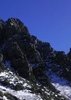
The morning map shows the fire creeping westward on the rim from East Pocket knob. That "wilderness" is some of the worst forest imaginable. However, I attached my 2011 exploratory photo set of the Barney Tract, which is the private in-holding in the NW corner of section 31 west of East Pocket. That is an area of never harvested "virgin" ponderosa pine, with some very impressive pines, for dry site, or one not in a moist canyon. I advocate for fire in that stand, however, it needs some thinning of the younger poles that seeded in 100 years ago, and most importantly it needs some preventative TLC by raking and hauling duff from the thick (> 6 inches) layers around tree bases, and in a few areas of dense canopy growth. Historically, these sites burned often enough that these duff accumulations were rare or non-existent.

McKenna Park, in the Gila Wilderness, is a close parallel to the Barney, but it had several fires since 1900. The last few burned through in 2003, before I hike through and took pics in May of 2010, and then the Miller and Whitewater Baldy came through again in 11 and 12. The duff had built up by 2003 and while the effects were not noticeable at first, there is the effect of root char, and stem girdling, which allows fungus to get into the stem, rot it and the roots, and then in winds, the trees blow over easier. Almost all the fresh down stems from the spring of 2010 had roots that were rotting. Even if the fire is a backing one, with minimal crown scorch, the effects on the roots of these old trees can kill them, even if not right away.

Given that the Barney is essentially a museum piece, and worth a higher level of protection, it would be worth keeping the fire out, despite the need for it in the future. Mostly, I favor raking, hauling and burning, and then simply having some very low intensity fires in a few years.

It will be interesting to see where the FS stops western progress. The 2 track through the stand might be a good spot, and if done, a small patch of the tract will burn and could be a contrast with the main portion.
🍭
contribute to this member driven resource
ie: RS > Save/Share after hikes Route Scout GPS Topo Mapper on the App Store Route Scout GPS Topo Mapper on Google Play
User avatar
hippiepunkpirate
Guides: 25 | Official Routes: 23
Triplogs Last: 272 d | RS: 0
Water Reports 1Y: 0 | Last: 3,645 d
Joined: May 30 2008 7:43 am
City, State: Peoria, AZ
Contact:

Re: Slide Fire - Oak Creek Canyon - Sedona

Post by hippiepunkpirate »

Not sure if it's ever been made known, but Jim has a degree in forestry, in case you couldn't tell by his above post...
contribute to this member driven resource
ie: RS > Save/Share after hikes Route Scout GPS Topo Mapper on the App Store Route Scout GPS Topo Mapper on Google Play
User avatar
azbackpackr
Guides: 27 | Official Routes: 23
Triplogs Last: 77 d | RS: 0
Water Reports 1Y: 0 | Last: 770 d
Joined: Jan 21 2006 6:46 am
City, State: Eagar AZ

Re: Slide Fire - Oak Creek Canyon - Sedona

Post by azbackpackr »

From Inciweb a little while ago:

"Over a hundred spot fires were found last night with an infrared flight north of the fire. Crews were able to line and mop-up the spots easily due to past fuel treatments in the area.
Firefighter safety is our number one priority.

Due to the extreme terrain, our suppression strategy is to create containment lines in safer areas far ahead of the fire, reinforcing these lines with low-intensity burnout operations. This means fire managers are expecting the size of the fire’s footprint to greatly increase, but many areas will receive much lighter fire behavior."
There is a point of no return unremarked at the time in most lives. Graham Greene The Comedians
A clean house is a sign of a misspent life.
contribute to this member driven resource
ie: RS > Save/Share after hikes Route Scout GPS Topo Mapper on the App Store Route Scout GPS Topo Mapper on Google Play
User avatar
azbackpackr
Guides: 27 | Official Routes: 23
Triplogs Last: 77 d | RS: 0
Water Reports 1Y: 0 | Last: 770 d
Joined: Jan 21 2006 6:46 am
City, State: Eagar AZ

Re: Slide Fire - Oak Creek Canyon - Sedona

Post by azbackpackr »

We've had a little bit of rain in the area. Let's hope that helps the firefighters!
There is a point of no return unremarked at the time in most lives. Graham Greene The Comedians
A clean house is a sign of a misspent life.
contribute to this member driven resource
ie: RS > Save/Share after hikes Route Scout GPS Topo Mapper on the App Store Route Scout GPS Topo Mapper on Google Play
User avatar
pixelfrog
Triplogs Last: 1,967 d | RS: 0
Water Reports 1Y: 0 | Last: never
Joined: Apr 11 2002 10:00 am
City, State: Chandler, AZ
Contact:

Re: Slide Fire - Oak Creek Canyon - Sedona

Post by pixelfrog »

Any word on the investigation into the slime bag who started this fire? Someone had to have seen something.

I think in this case the death penalty is probably too easy, can we torture them for the rest of their lives? Sorry, I am heart broken.
contribute to this member driven resource
ie: RS > Save/Share after hikes Route Scout GPS Topo Mapper on the App Store Route Scout GPS Topo Mapper on Google Play
User avatar
RedRoxx44
Guides: 5 | Official Routes: 0
Triplogs Last: 6 d | RS: 0
Water Reports 1Y: 0 | Last: 6,292 d
Joined: Feb 15 2003 8:07 am
City, State: outside, anywhere

Re: Slide Fire - Oak Creek Canyon - Sedona

Post by RedRoxx44 »

Looking at Facebook photos from inciweb from the Call of the Canyon trail I'd say things look pretty good for West Fork, most of the canopy looks intact. It's the flooding later that might be the bigger problem as those here have said.
contribute to this member driven resource
ie: RS > Save/Share after hikes Route Scout GPS Topo Mapper on the App Store Route Scout GPS Topo Mapper on Google Play
Post Reply

Return to “Fire & Area Closures”