 Route Editor

I'm thinking about planning an overnight here: Wire Pass to White House.
I looked at the March (12) temps at the bottom of the Hike Description page, but they were for the Grand Canyon (top?) Temps from the city of Page website seemed slightly higher, high temps in the 60's.
Question is, does anyone think that we may be at risk for hypothermia hiking through pools at these temps (even being careful)? Then again, with little rain, is it possible that there will be no water?
There is not much vertical descent, so I suppose I cannot count on temps increasing as we go down.
If anyone has been here this early, please deposit advice here.
Thanks!
Buckskin Gulch in March-- too cold?
Moderator: HAZ - Moderators
Linked Guides none
Linked Area, etc none
-
 PuaGuides: 1 | Official Routes: 0Triplogs Last: 7,046 d | RS: 0Water Reports 1Y: 0 | Last: never
 - Joined: Aug 07 2005 8:13 pm
- City, State: Santa Barbara, CA
contribute to this member driven resource
ie: RS > Save/Share after hikes 

-
 wetbeaverloverGuides: 0 | Official Routes: 0Triplogs Last: none | RS: 0Water Reports 1Y: 0 | Last: never
 - Joined: Jul 24 2004 8:41 am
- City, State: Rimrock Az
Any deep, shaded water in slot canyons will be FREEZING cold in march. I have never been in that particular slot but i know how cold the water is in some of the pools in paria in mid summer is. As much as i hate bearing bad news, I would reconsider long watery treks in March in Arizona unless they are to a hot tub 
Dan
contribute to this member driven resource
ie: RS > Save/Share after hikes
-
PuaGuides: 1 | Official Routes: 0Triplogs Last: 7,046 d | RS: 0Water Reports 1Y: 0 | Last: never
- Joined: Aug 07 2005 8:13 pm
- City, State: Santa Barbara, CA
In response to wetbeaverlover's reply:
I really appreciate your advice. Better safe than sorry!
I read some descriptions where they did not encounter water for quite a ways down buckskin gulch. Perhaps we could check out Wire Pass and do an out-and-back as far as we could go.
Can you see how determined I am now that I've seen the photos and descriptions??!! Darn it!
contribute to this member driven resource
ie: RS > Save/Share after hikes
-
wetbeaverloverGuides: 0 | Official Routes: 0Triplogs Last: none | RS: 0Water Reports 1Y: 0 | Last: never
- Joined: Jul 24 2004 8:41 am
- City, State: Rimrock Az
In response to Pua's reply: Pua, Don't rely on my word though, having never been in canyon I don't know the particulars. But Hang tight, im sure someone more qualified on this canyon will respond to you. I just know that I have been chilled to the bone a few times slogging through much sunnier canyons.
Dan
contribute to this member driven resource
ie: RS > Save/Share after hikes
-
 LizardGuides: 15 | Official Routes: 0Triplogs Last: 5,500 d | RS: 0Water Reports 1Y: 0 | Last: never
 - Joined: Feb 05 2002 6:40 pm
- City, State: Phoenix, AZ
I was in the Page area this last March and did a number of canyon hikes, including an overnight down Wire Pass then out through Coyote Buttes the next day. The daytime temps were extremely mild (T-shirt and shorts weather), and the evenings were fine with a sleeping bag. I think that a hike down Buckskin may be doable if the dry conditions we've had recently continue.
"Of course we weren't lost. We were merely where we shouldn't have been, without knowing exactly where that was."
contribute to this member driven resource
ie: RS > Save/Share after hikes
-
PuaGuides: 1 | Official Routes: 0Triplogs Last: 7,046 d | RS: 0Water Reports 1Y: 0 | Last: never
- Joined: Aug 07 2005 8:13 pm
- City, State: Santa Barbara, CA
Thanks for the info. Did you camp at the end of Wire Pass/intersection with Buckskin, or further down somewhere?
As the above poster said, the water will surely be cold, but maybe I'll call the BLM up there and see if there actually is any water in there.
All members of the potential group are from northern climes so we should be good with sleeping (even in cold temps). I'm just worried about tons of cold water.
Still soliciting advice if anyone has been up there really recently.
contribute to this member driven resource
ie: RS > Save/Share after hikes
-
 NighthikerGuides: 0 | Official Routes: 0Triplogs Last: 1,644 d | RS: 0Water Reports 1Y: 0 | Last: never
 - Joined: Feb 03 2002 6:59 am
- City, State: Payson
Review Michael R. Kelsey books for hiking the Canyon Country for information, may be of help and his books are excellent.
jk
contribute to this member driven resource
ie: RS > Save/Share after hikes
-
PuaGuides: 1 | Official Routes: 0Triplogs Last: 7,046 d | RS: 0Water Reports 1Y: 0 | Last: never
- Joined: Aug 07 2005 8:13 pm
- City, State: Santa Barbara, CA
contribute to this member driven resource
ie: RS > Save/Share after hikes
-
 hikeazGuides: 6 | Official Routes: 0Triplogs Last: 1,239 d | RS: 0Water Reports 1Y: 0 | Last: 1,239 d
 - Joined: May 13 2002 10:07 am
- City, State: Tempe, AZ
- Contact:
The pool depth will be determined by recent rains, so an advance condition report will be day-to-day. That said, any water that is IN the pools will not likely evaporate much between now & March.
The best data (other than from someone just completing the hike) can be found @ the Paria ranger station, although they have no phone you can call. The next best Gov't option is the BLM office in Kanab; although they haven't had up-to-the-minute data whenever I've contacted them.
You may try Steve or Susan @ (928) 691-1047 or Easton at 928-660-2674. They may know the pool depth or be willing to check @ the Paria ranger station. These folks are not Gov't employees, they're friends of mine and would be doing this as a favor to you. You can tell them that Kurt from Phoenix says "Hi".
kurt
"The censorship method ... is that of handing the job over to some frail and erring mortal man, and making him omnipotent on the assumption that his official status will make him infallible and omniscient."
George Bernard Shaw
George Bernard Shaw
contribute to this member driven resource
ie: RS > Save/Share after hikes
-
PuaGuides: 1 | Official Routes: 0Triplogs Last: 7,046 d | RS: 0Water Reports 1Y: 0 | Last: never
- Joined: Aug 07 2005 8:13 pm
- City, State: Santa Barbara, CA
Just for anyone reading this for reference later on, I had a chat with Kurt (hikeaz), and the consensus is that it is something that cannot be predicted now, as conditions change.
I'm going to get permits, wait until then, check conditions and do a out-and-back as far as we can go if there is too much water, and camp there somewhere. If there isn't water, we may do the backpack, as everyone says it's awesome!
Thanks for the book suggestion, I'm reading the Kelsey book now!
I'm going to get permits, wait until then, check conditions and do a out-and-back as far as we can go if there is too much water, and camp there somewhere. If there isn't water, we may do the backpack, as everyone says it's awesome!
Thanks for the book suggestion, I'm reading the Kelsey book now!
contribute to this member driven resource
ie: RS > Save/Share after hikes
-
 andmaherGuides: 0 | Official Routes: 0Triplogs Last: none | RS: 0Water Reports 1Y: 0 | Last: never
 - Joined: Apr 07 2004 10:44 am
- City, State: Tempe, AZ
Kelsey
Howdy Pua:
I did Davis Gulch and 50 Mile Canyon up the Escalante from Lake Powell about the same time last year. Temps were no problem, mild days and chilly (but pleasant) nights. No pools to cross tho. One last thing; beware of Kelsey! Great writeups and trail info but dude is hardcore!
Good luck,
-andrew
I did Davis Gulch and 50 Mile Canyon up the Escalante from Lake Powell about the same time last year. Temps were no problem, mild days and chilly (but pleasant) nights. No pools to cross tho. One last thing; beware of Kelsey! Great writeups and trail info but dude is hardcore!
Good luck,
-andrew
contribute to this member driven resource
ie: RS > Save/Share after hikes
-
PuaGuides: 1 | Official Routes: 0Triplogs Last: 7,046 d | RS: 0Water Reports 1Y: 0 | Last: never
- Joined: Aug 07 2005 8:13 pm
- City, State: Santa Barbara, CA
contribute to this member driven resource
ie: RS > Save/Share after hikes
-
 RedRoxx44Guides: 5 | Official Routes: 0Triplogs Last: 5 d | RS: 0Water Reports 1Y: 0 | Last: 6,521 d
 - Joined: Feb 15 2003 8:07 am
- City, State: outside, anywhere
M Kelsey
I've had the good luck to run into Mike Kelsey twice in utah, once in Grand Gulch and once at Capitol Reef. He is the most fit I think almost 60 year old I've ever met. He is indeed hardcore as this type of stuff is pretty much all he does. I was able to do Buckskin to White House in a day but it is a long one. Did both my trips in May, since it has been dry you probably won't have too many cold deep pools to wade as some can recede and be gotton around. However, have fun at the "cesspool".
contribute to this member driven resource
ie: RS > Save/Share after hikes
-
PuaGuides: 1 | Official Routes: 0Triplogs Last: 7,046 d | RS: 0Water Reports 1Y: 0 | Last: never
- Joined: Aug 07 2005 8:13 pm
- City, State: Santa Barbara, CA
contribute to this member driven resource
ie: RS > Save/Share after hikes
-
hikeazGuides: 6 | Official Routes: 0Triplogs Last: 1,239 d | RS: 0Water Reports 1Y: 0 | Last: 1,239 d
- Joined: May 13 2002 10:07 am
- City, State: Tempe, AZ
- Contact:
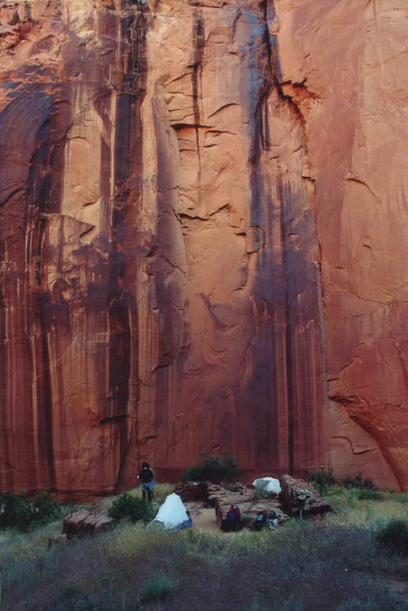
This is the "lower" confluence camp - there is one above it, as well (thus the "lower" conotation):)Pua wrote: I was obsessively searching for pics of the campsite at the convergence, as we'd do it in 2 days.
Thanks!
Lynn

"Upper" confluence looks like this..
"The censorship method ... is that of handing the job over to some frail and erring mortal man, and making him omnipotent on the assumption that his official status will make him infallible and omniscient."
George Bernard Shaw
George Bernard Shaw
contribute to this member driven resource
ie: RS > Save/Share after hikes
-
andmaherGuides: 0 | Official Routes: 0Triplogs Last: none | RS: 0Water Reports 1Y: 0 | Last: never
- Joined: Apr 07 2004 10:44 am
- City, State: Tempe, AZ
Kelsey
No intent to demean Mr. Kelsey. I've made great use of his blue book (CO Plateau). Just galling that he's in so much better shape at nearly twice my age  Have to factor in about 50% more time and effort than his trail write-ups imply.
contribute to this member driven resource
ie: RS > Save/Share after hikes
-
PuaGuides: 1 | Official Routes: 0Triplogs Last: 7,046 d | RS: 0Water Reports 1Y: 0 | Last: never
- Joined: Aug 07 2005 8:13 pm
- City, State: Santa Barbara, CA
contribute to this member driven resource
ie: RS > Save/Share after hikes