 Route Editor

The Finger Rock trail to Mt Kimbal will do just that. It is only 10.2 miles round trip but it gains 4200’ in the first five miles and that’s the way you come back so you have a 8400’ elevation change on this one. Straight up and straight down with no smooth path at all, just granite boulders strewn everywhere in your way and coming down was harder than going up (going up wasn’t that easy either). The trail head starts at the end of Alvernon at the Catalina mountains in Tucson.
We walked under granite cliffs.
Soaring Cliffs
Gazed on beautiful flowers.
Flowers on Granite
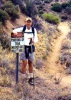
And we were stalked by fierce predators.
Fierce Hairy Predator
We walked eight hours on this one. Yes after all the remodeling we are a little soft but a good time was had by all. The views over the north side of the mountains were excellent. Next time we will take more than three liters of water apiece as we ran out in the last hour. We did have a few food breaks to keep up the energy.
If you Phoenix folks ever get down in Southern Arizona, be sure a check out the awesome trails in the Catalina Mountains. This spot is only six miles north of my house.
This Hike will Kick You Hard!
Moderator: HAZ - Moderators
Linked Area, etc none
-
 BoyNhisDogGuides: 0 | Official Routes: 0Triplogs Last: none | RS: 0Water Reports 1Y: 0 | Last: never
 - Joined: Feb 03 2002 2:09 pm
- City, State: Tucson, AZ
contribute to this member driven resource
ie: RS > Save/Share after hikes 

-
 nealzGuides: 4 | Official Routes: 0Triplogs Last: 8,759 d | RS: 0Water Reports 1Y: 0 | Last: never
 - Joined: Feb 10 2002 2:20 pm
- City, State: Alpine, AZ
contribute to this member driven resource
ie: RS > Save/Share after hikes
-
BoyNhisDogGuides: 0 | Official Routes: 0Triplogs Last: none | RS: 0Water Reports 1Y: 0 | Last: never
- Joined: Feb 03 2002 2:09 pm
- City, State: Tucson, AZ
Nealz, the Summit Hut is having their annual fall sale tomorrow and Sunday too. It is always a good one. Too bad I have to be at the house, taking delivery of our new dinning room table. The other one was destroyed in the great explosion while we were in Ontario. Finally we will have a place to eat again. The Summit Hut sale is a dangerous place for me anyway because I spend way too much. Oh well, such is life.
Glen
contribute to this member driven resource
ie: RS > Save/Share after hikes
-
nealzGuides: 4 | Official Routes: 0Triplogs Last: 8,759 d | RS: 0Water Reports 1Y: 0 | Last: never
- Joined: Feb 10 2002 2:20 pm
- City, State: Alpine, AZ
 I'm headed up to the Mazatzals this weekend anyway so I'll be out of harm's way too.
contribute to this member driven resource
ie: RS > Save/Share after hikes
-
 SredfieldGuides: 4 | Official Routes: 4Triplogs Last: 102 d | RS: 0Water Reports 1Y: 0 | Last: 730 d
 - Joined: Sep 08 2002 1:07 pm
- City, State: Ahwatukee, AZ
I did the Pima Canyon-Ventana Canyon trip last year about this time, its in the same vicinity. It was the fatal trip that did my knee in, surgery required. It is a butt-kicker. There is no redeeming feature, coming down Ventana was awful. To top if off, you have to walk out thru a condo development. Not again.
contribute to this member driven resource
ie: RS > Save/Share after hikes
-
 MikeGuides: 5 | Official Routes: 0Triplogs Last: 8,709 d | RS: 0Water Reports 1Y: 0 | Last: never
 - Joined: Feb 03 2002 11:45 am
- City, State: Scottsdale, AZ
REI and Summit Hut are both having sales this weekend. Thank goodness my schedule is full!! Well, except for tomorrow for few hours... :twisted:nealz wrote:Oh, thanks pal... like, I needed to know that!BoyNhisDog wrote:Nealz, the Summit Hut is having their annual fall sale tomorrow and Sunday too.I'm headed up to the Mazatzals this weekend anyway so I'll be out of harm's way too.
-Nealz
contribute to this member driven resource
ie: RS > Save/Share after hikes
-
 CindyCGuides: 0 | Official Routes: 0Triplogs Last: 8,761 d | RS: 0Water Reports 1Y: 0 | Last: never
 - Joined: Apr 23 2002 12:17 pm
contribute to this member driven resource
ie: RS > Save/Share after hikes
-
 FritzskiGuides: 43 | Official Routes: 0Triplogs Last: 3,452 d | RS: 0Water Reports 1Y: 0 | Last: never
 - Joined: Feb 04 2002 8:26 am
- City, State: Gilbert, AZ
contribute to this member driven resource
ie: RS > Save/Share after hikes
-
 azhiker96Guides: 0 | Official Routes: 0Triplogs Last: 1,174 d | RS: 2Water Reports 1Y: 0 | Last: never
 - Joined: Feb 03 2002 10:17 am
- City, State: Gilbert, AZ
Boynhisdog, Did you go to finger rock? I did that hike with my brother a couple of years ago. It was in April and was quite a workout. There's a little side trail that heads off into the canyon and up the other side, I think it was about 3 miles into the hike. Heading up the other side we traveled through a few gnat swarms. I inhaled one and started coughing. My brother starting laughing because he was wondering if I was being careful around those pesky flying things. I finally got him coughed out and was gratified to see the gnat got the worst end of the deal. The last part of the hike is a bit of a puzzle as the trail peters out near the finger. We finally found our way up. Along the way we saw a nice cane that someone had left behind. When we started our descent we wasted time on a couple of sucker trails that led to steep dropoffs. We finally refound the trail and made our way back out. Quite a fun adventure!
contribute to this member driven resource
ie: RS > Save/Share after hikes
-
BoyNhisDogGuides: 0 | Official Routes: 0Triplogs Last: none | RS: 0Water Reports 1Y: 0 | Last: never
- Joined: Feb 03 2002 2:09 pm
- City, State: Tucson, AZ
Quite a fun adventur is right azhiker. It is a trail through a fantastic landscape of impossibly angled huge chunks of granite pushed skyward. Steep narrow canyons carve their way through all of this. A sensory overload for sure. We did not go over to Finger Rock as that turns into a technical rock climb but when I was younger a trio of us college guys bushwacked our way up to the top of Prominent Point, the overlooking structure to the west of Finger Rock. The endless veiw and thousands of features in the landscape gave me a sort of vertigo of the senses. It was just too icredibly beautiful. Coming down was a major undertaking. We traveled along a knife sharp rigde for a while and then down through an impossible canyon. When I finished that hike I felt as I do now, that I could run around the world.
Glen
contribute to this member driven resource
ie: RS > Save/Share after hikes
-
 LizardGuides: 15 | Official Routes: 0Triplogs Last: 5,499 d | RS: 0Water Reports 1Y: 0 | Last: never
 - Joined: Feb 05 2002 6:40 pm
- City, State: Phoenix, AZ
Great photos! This is one of my favorite trails in the Tucson area, its just a few minutes from my apartment. It and Pima Canyon see much less visitors than the Sabino Canyon area.
If you're looking for something a little less challenging, you can leave the trail when it starts to ascend and stay on the floor of Finger Rock Canyon. There are some interesting areas to explore upcanyon.
If you're looking for something a little less challenging, you can leave the trail when it starts to ascend and stay on the floor of Finger Rock Canyon. There are some interesting areas to explore upcanyon.
"Of course we weren't lost. We were merely where we shouldn't have been, without knowing exactly where that was."
contribute to this member driven resource
ie: RS > Save/Share after hikes
-
 imikeGuides: 253 | Official Routes: 0Triplogs Last: 3,056 d | RS: 0Water Reports 1Y: 0 | Last: 4,727 d
 - Joined: Nov 05 2008 10:05 pm
- City, State: Cloudcroft, NM
Re: This Hike will Kick You Hard!
My favorite trail when I lived in Tucson... liked it so much I hiked it three times one day (13h 20min)... now, with 2009 being my 60th year, I'm planning to visit tucson in January and try that triple loop once again... see if age really matters.
time will tell
mj
time will tell
mj
Ageless Mind... Timeless Body... No Way! Use It and Lose It. Just the way it is...
contribute to this member driven resource
ie: RS > Save/Share after hikes
-
 azbackpackrGuides: 34 | Official Routes: 30Triplogs Last: 35 d | RS: 0Water Reports 1Y: 8 | Last: 44 d
 - Joined: Jan 21 2006 6:46 am
- City, State: Eagar AZ
Re: This Hike will Kick You Hard!
Wow, look at the dates on the beginning of the thread!
Last time I hiked in Tucson, a couple of years ago, it was to do Finger Rock Trail with some folks from SAHC. It was fun.
I always tell my Tucson pals to train on that trail for Grand Canyon, but many of them don't like it because they say it is too hard. Go figger. Anyway, when I lived in Tucson it was fairly close to my house. I've hiked it quite a bit.
There is a point of no return unremarked at the time in most lives. Graham Greene The Comedians
A clean house is a sign of a misspent life.
A clean house is a sign of a misspent life.
contribute to this member driven resource
ie: RS > Save/Share after hikes
-
 desert spiritGuides: 0 | Official Routes: 0Triplogs Last: none | RS: 0Water Reports 1Y: 0 | Last: never
 - Joined: Nov 11 2008 6:20 am
- City, State: Tucson, AZ
Re: This Hike will Kick You Hard!
Isn't it cool how there's such a continuity when talking about trails? In a world where it seems like nothing stays the same for long, the mountains and deserts are always there for us, unchanged and unmoved.azbackpackr wrote:Wow, look at the dates on the beginning of the thread!
Got this trail on my to-do list. In fact, it's such a glorious morning, I may do this today.
contribute to this member driven resource
ie: RS > Save/Share after hikes
-
 JeffshadowsGuides: 28 | Official Routes: 7Triplogs Last: 4,275 d | RS: 0Water Reports 1Y: 0 | Last: 4,432 d
 - Joined: Jan 30 2008 8:46 am
- City, State: Old Pueblo
Re: This Hike will Kick You Hard!
That's the trail I always fall back on when I'm thinking: "I want to go hike but have no idea where to go..."
AD-AVGVSTA-PER-ANGVSTA
contribute to this member driven resource
ie: RS > Save/Share after hikes
-
 JimmyLydingGuides: 111 | Official Routes: 94Triplogs Last: 767 d | RS: 0Water Reports 1Y: 0 | Last: 2,338 d
 - Joined: Feb 16 2007 3:17 pm
- City, State: Walnut Creek, CA
Re: This Hike will Kick You Hard!
That trail kicked my heinie. The thing about the 4200' of elevation gain is that you only gain a few hundred feet in the first mile. The bulk of that 4200' is in 4 miles, and the trail is not good. Don't go on this trail if you're not sure-footed, or have vertigo. It IS spectacular, however. Anyone who's planning on doing this trail had better eat their Wheaties and bring their lunchbox. A good way to enjoy this trail without putting one's life and limbes in danger is to go to Linda Vista. It is incorrectly identified in the Falcon Guide.
contribute to this member driven resource
ie: RS > Save/Share after hikes
-
JeffshadowsGuides: 28 | Official Routes: 7Triplogs Last: 4,275 d | RS: 0Water Reports 1Y: 0 | Last: 4,432 d
- Joined: Jan 30 2008 8:46 am
- City, State: Old Pueblo
Re: This Hike will Kick You Hard!
Linda Vista is worth a visit, for sure. I sometimes make a trip out of just going there to enjoy the view. A trail breaks left near there to Finger Rock, as well. I was out one day making pretty good time into Kimball when a guy clad only in spandex short ran right past me...literally. It was on that section near the little stream crossing where the pines first start to show up. He was an animal... ;)
AD-AVGVSTA-PER-ANGVSTA
contribute to this member driven resource
ie: RS > Save/Share after hikes
-
desert spiritGuides: 0 | Official Routes: 0Triplogs Last: none | RS: 0Water Reports 1Y: 0 | Last: never
- Joined: Nov 11 2008 6:20 am
- City, State: Tucson, AZ
Re: This Hike will Kick You Hard!
Is it worse than Angel's Landing in Zion?JamesLyding wrote:Don't go on this trail if you're not sure-footed, or have vertigo
contribute to this member driven resource
ie: RS > Save/Share after hikes
-
JimmyLydingGuides: 111 | Official Routes: 94Triplogs Last: 767 d | RS: 0Water Reports 1Y: 0 | Last: 2,338 d
- Joined: Feb 16 2007 3:17 pm
- City, State: Walnut Creek, CA
Re: This Hike will Kick You Hard!
I've never been to Zion (but it's on the list!). It's not as if you're walking along the edge of a big vertical ledge on the Finger Rock trail, it's that you have to go across a number of bare rock faces that are covered in loose gravel. Anyone who slips on these stands a good chance of falling a long way because it's pretty steep to the canyon bottom. Going uphill there are usually cliffs on your right, and a big drop-off to your left. I think that going down this trail is worse than going up because there's so many steep step-downs on a loose/rocky trail.
Linda Vista is a great place to stop and read a book.
Linda Vista is a great place to stop and read a book.
contribute to this member driven resource
ie: RS > Save/Share after hikes
-
JeffshadowsGuides: 28 | Official Routes: 7Triplogs Last: 4,275 d | RS: 0Water Reports 1Y: 0 | Last: 4,432 d
- Joined: Jan 30 2008 8:46 am
- City, State: Old Pueblo
Re: This Hike will Kick You Hard!
The descent is really bad, but there are worse ones in the Catalinas (If you can believe it.) Finger is better made into a shuttle, something like: up Finger and out through Pima, etc...
AD-AVGVSTA-PER-ANGVSTA
contribute to this member driven resource
ie: RS > Save/Share after hikes