 Route Editor

Howdy,
I'm considering a trip to W. Clear Creek in a couple of weeks. We'd be descending via Meadow Canyon then heading east at the confluence w/ W. Clear Creek. Through the white boxes then exiting up the hill to Cash Tank. I've done this trip many times and water levels have always been good but it's been SO darn dry this year.
Has anybody been down there this season? If so, how are the water levels? Is it worth it?
Also, any info on the extent of the fire damage from the 'Tram Fire' earlier this year?
Thanks!
--Eric
West Clear Creek H20 Levels
Moderator: HAZ - Moderators
Linked Area, etc none
-
 ericrakGuides: 0 | Official Routes: 0Triplogs Last: none | RS: 0Water Reports 1Y: 0 | Last: never
 - Joined: Mar 19 2002 1:12 pm
contribute to this member driven resource
ie: RS > Save/Share after hikes 

-
 pixelfrogGuides: 0 | Official Routes: 0Triplogs Last: 2,195 d | RS: 0Water Reports 1Y: 0 | Last: never
 - Joined: Apr 11 2002 10:00 am
- City, State: Chandler, AZ
- Contact:
Ha ha, as soon as I saw this topic title I knew it was you Rak!
The Tram fire was approx. 6 miles west of Clints Well and burned a total of 190 acres. I heard it burned down into the canyon a bit, but haven't heard anyone's accounts of how the area looks. With the level of drought we've had this year we're probably very lucky it burned that little.
Well, I'm ready to go check it out when you are dude!
P
contribute to this member driven resource
ie: RS > Save/Share after hikes
-
 azrocksGuides: 0 | Official Routes: 0Triplogs Last: none | RS: 0Water Reports 1Y: 0 | Last: never
 - Joined: Mar 21 2002 5:38 pm
contribute to this member driven resource
ie: RS > Save/Share after hikes
-
ericrakGuides: 0 | Official Routes: 0Triplogs Last: none | RS: 0Water Reports 1Y: 0 | Last: never
- Joined: Mar 19 2002 1:12 pm
meadow canyon
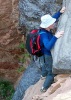
The route from Meadow is the most technical descent into W. Clear that I know of. It involves 2 rappells: an 80' and 40' then a chute that is steep but doesn't require a rope, although some folks feel more comfortable with a handline down the chute. If that's the case, there's a good tree to anchor from just at the top. Both rappells also have good anchors, the first is a chockstone and the second is a large pine. Bring some webbing (about 15') and rap rings to anchor off of the chockstone and, if possible, try to use a webbing retrieval system to reduce impact. Along the way, during wet years you may have to cross a couple of pools. These can be frigid on cold days.
Some pics of the rap and the chute on my friend Chris' site: http://dieinthedesert.com/WClear.htm
About a mile after the chute, Meadow ends at the confluence with W. Clear. This is usually the first sign of running water. From there, go east to hanging gardens then the white boxes or go west to the red boxes which, in my opinion, are much more impressive than the white boxes. After the red boxes, I usually exit at Rim Tank. There are a couple of easy 5th class sections* of this ascent and it's very steep. You'll need to study your topo and make sure you're heading up the correct tributary. You'll know when you see a fixed handline at the first 5th class section.
Another good (the best as far as i'm concerned) variation of the trip is to drop in at cash tank, do the white boxes and continue west past hanging gardens and Meadow canyon and then do the red boxes. You'll need to plan on camping in the canyon. It's kind of a long weekend trip but way, way fun. If you plan to do this route, plan on a lot of swimming. If anybody needs beta on W. Clear, just let me know.
--Eric
* <<Disclaimer: If you, or somebody in your party doesn't have solid climbing (at least 5.10 outside, not the gym) skills, I DO NOT recommend the Rim Tank exit. While I consider the 5th class sections easy, they would probably be difficult for those with no or limited climbing experience. A fall while attempting any of the 5th class sections could be very serious and you don't want to be stuck in that area. If you're a climber leading a group, at least bring a short rope or webbing to set up handlines or put the others on belay. >>
contribute to this member driven resource
ie: RS > Save/Share after hikes
-
azrocksGuides: 0 | Official Routes: 0Triplogs Last: none | RS: 0Water Reports 1Y: 0 | Last: never
- Joined: Mar 21 2002 5:38 pm
contribute to this member driven resource
ie: RS > Save/Share after hikes
-
ericrakGuides: 0 | Official Routes: 0Triplogs Last: none | RS: 0Water Reports 1Y: 0 | Last: never
- Joined: Mar 19 2002 1:12 pm
I'm assuming you know which dirt road to take off of 260.
From the road that leads to Cash Tank, park at the bottom of a steep hill just before a cow pond and right next to meadow canyon. There's a clearing with a campfire ring. You should be able to easily find this on the topo for the area. From the parking area, there's an old dirt road that runs parallel to the canyon towards the powerlines. Hike down this road a bit and look for an old barbed wire fence on the right, this marks a rough trail that drops easily into the canyon. From there, boulder-hop down the canyon about a mile to the first rappell.
Keep in mind that unless you set up a shuttle at cash or rim tank, you'll have about a 3-4 mile hike across the desert back to your vehicle (which, if you're me, contains a cooler full of cold beer) so be sure to fill up your h20 containers before leaving the canyon.
--Eric
contribute to this member driven resource
ie: RS > Save/Share after hikes
-
azrocksGuides: 0 | Official Routes: 0Triplogs Last: none | RS: 0Water Reports 1Y: 0 | Last: never
- Joined: Mar 21 2002 5:38 pm
contribute to this member driven resource
ie: RS > Save/Share after hikes
-
azrocksGuides: 0 | Official Routes: 0Triplogs Last: none | RS: 0Water Reports 1Y: 0 | Last: never
- Joined: Mar 21 2002 5:38 pm
We did the white box loop from Cash Tank and the red boxes in and out
of Rim Tank. Conditions are perfect. The water was a balmy 65, flowing
strong enough to keep the pools full and the waterfalls gushing. Best
of all, not a single bug bite ! From the line on the walls, the level
might be down 3 inches, but otherwise you wouldn't notice. There's no
fire damage, and even some mud on the Cash Tank road, but the drought
has spawned a few brown patches of dead trees up on the rim. The upper
gully at Rim Tank is very unstable, and ready to avalanche. The flow
that might stabilize it goes into stock tanks, good for wild life, bad
for hikers !
contribute to this member driven resource
ie: RS > Save/Share after hikes
-
ericrakGuides: 0 | Official Routes: 0Triplogs Last: none | RS: 0Water Reports 1Y: 0 | Last: never
- Joined: Mar 19 2002 1:12 pm
contribute to this member driven resource
ie: RS > Save/Share after hikes
-
pixelfrogGuides: 0 | Official Routes: 0Triplogs Last: 2,195 d | RS: 0Water Reports 1Y: 0 | Last: never
- Joined: Apr 11 2002 10:00 am
- City, State: Chandler, AZ
- Contact:
contribute to this member driven resource
ie: RS > Save/Share after hikes