 Route Editor

EDIT 9-13-10: After hiking Kachina Trail with Jake yesterday, we determined the original planned photographing spot isn't very good in the evening... Nearby ridges block the best of the evening light. So, the new, tentative plan is Hart Prairie Saturday evening. After shooting through sunset there, we'll hop on fr522 off Snowbowl road and find a place to car camp near Freidlen Prairie. Sunday morning we'll wake up bright and early (more like dark and early) and hike no more than 2 miles on the Kachina Trail to find some aspens and meadows. Plans still subject to change, of course, as we do more scouting.
Hey HAZ photographers!
Jake (hippiepunkpirate), Jon (jonnybackpack) and I are putting together an autumn photography workshop/group hike/camping trip at the Peaks, October 9th and 10th.
The plan, as of now, is to meet up late morning on Saturday, October 9th, and drive to the Freidlein Prairie trailhead. Hike the lower portion of the Kachina Trail and photograph the beautiful Kachina meadows in the evening. Car-camp somewhere nearby Saturday night, wake up pre-sunrise Sunday morning and head to Lockett Meadow. Photograph the Lockett Meadow area for sunrise, then head into the Inner Basin to capture the rest of the morning light.
Although this is obviously organized like a normal group hike, the focus will be on photography. Bring a camera and tripod! We'll be visiting prime locations during the best light, so there should be plenty of opportunity for some awesome photos... Not to mention the sharing of knowledge from fellow photographers ;)
I hope some of you are interested!
HAZ Fall Photo Workshop
Moderators: HAZ Group Coordinators, HAZ - Moderators
-
 JoelHazeltonGuides: 16 | Official Routes: 1Triplogs Last: 143 d | RS: 1Water Reports 1Y: 2 | Last: 303 d
 - Joined: Mar 22 2006 7:45 am
- City, State: Phoenix, AZ
- Contact:
HAZ Fall Photo Workshop
Last edited by JoelHazelton on Sep 13 2010 5:45 pm, edited 5 times in total.
"Arizona is the land of contrast... You can go from Minnesota to California in a matter of minutes, then have Mexican food that night." -Jack Dykinga
http://www.joelhazelton.com
http://www.joelhazelton.com
contribute to this member driven resource
ie: RS > Save/Share after hikes 

-
 PaleoRobGuides: 171 | Official Routes: 78Triplogs Last: 670 d | RS: 24Water Reports 1Y: 0 | Last: 1,058 d
 - Joined: Apr 03 2006 12:21 pm
- City, State: Pocatello, ID
- Contact:
Re: HAZ Fall Photo Workshop
Mine came on (along with the oil light) when I put a hole in my Jetta's oil pan and the oil drained out on the slopes of the Sandias.chumley wrote:@cindyl - the check engine light indicates an emissions problem. In fact, its rarely anything that needs attention until you go in for your inspection.
contribute to this member driven resource
ie: RS > Save/Share after hikes
-
 cindylGuides: 0 | Official Routes: 0Triplogs Last: 1,185 d | RS: 10Water Reports 1Y: 0 | Last: 1,424 d
 - Joined: May 15 2009 12:28 pm
- City, State: Phoenix and Tucson, AZ
- Contact:
Re: HAZ Fall Photo Workshop
I've done that! I did that on the west side of Baboquivari on Tohono O'odham land. It's amazing how low to the ground those oil pans are, eh? So I was a bit worried this time, but since the malfunction indicator light went off a bit later in the day, I think it is more likely something to do with the temperature or elevation that I was at messing with the gauges - this little Jetta has never been so high! I just had everything checked with emissions in June - so I'm fairly certain that's not it, either. If/When it comes back, then I'll worry.PageRob wrote:when I put a hole in my Jetta's oil pan
There are just two switchbacks left. And another half-mile to the destination...
contribute to this member driven resource
ie: RS > Save/Share after hikes
-
 chumleyGuides: 94 | Official Routes: 239Triplogs Last: 3 d | RS: 73Water Reports 1Y: 95 | Last: 2 d
 - Joined: Sep 18 2002 8:59 am
- City, State: Tempe, AZ
Re: HAZ Fall Photo Workshop
oil lights should always be taken seriously. and promptly. you can destroy (permanently) your engine very quickly.
One of the key components in the emissions system (and frequent cause of the check engine light) is the oxygen sensor. I've never heard of driving at elevation having an effect on it, but I'm not exactly Mr. Goodwrench, and it sounds like it could be a logical correlation
One of the key components in the emissions system (and frequent cause of the check engine light) is the oxygen sensor. I've never heard of driving at elevation having an effect on it, but I'm not exactly Mr. Goodwrench, and it sounds like it could be a logical correlation
I'm not sure what my spirit animal is, but I'm confident it has rabies.
contribute to this member driven resource
ie: RS > Save/Share after hikes
-
 The_EagleGuides: 42 | Official Routes: 365Triplogs Last: 6 d | RS: 762Water Reports 1Y: 76 | Last: 14 d
 - Joined: Jan 20 2009 2:46 pm
- City, State: Far NE Phoenix, Az
- Contact:
Re: HAZ Fall Photo Workshop
@cindyl
Places like Pep Boys, AutoZone and AAmco will check it for free. (Not Checker Auto)
The computer does have a memory, so the light does not have to currently be on.
Places like Pep Boys, AutoZone and AAmco will check it for free. (Not Checker Auto)
The computer does have a memory, so the light does not have to currently be on.
There is a very fine line between "hobby" and "mental illness."
Dave Barry
Dave Barry

contribute to this member driven resource
ie: RS > Save/Share after hikes
-
 hippiepunkpirateGuides: 25 | Official Routes: 23Triplogs Last: 499 d | RS: 0Water Reports 1Y: 0 | Last: 3,872 d
 - Joined: May 30 2008 7:43 am
- City, State: Peoria, AZ
- Contact:
Re: HAZ Fall Photo Workshop
oliverr99 missed a Humphrey's hike in June because a light came on in her car...when she had it checked it, it was something about tire pressure from the high altitude or something
contribute to this member driven resource
ie: RS > Save/Share after hikes
-
 BobPGuides: 2 | Official Routes: 17Triplogs Last: 4 d | RS: 58Water Reports 1Y: 0 | Last: 455 d
 - Joined: Feb 26 2008 3:43 pm
- City, State: Scottsdale, AZ
Re: HAZ Fall Photo Workshop
that happened to me a couple of times also.hippiepunkpirate wrote:it was something about tire pressure from the high altitude or something
https://www.seeitourway.org
Always pronounce Egeszsegedre properly......
If you like this triplog you must be a friend of BrunoP
Always pronounce Egeszsegedre properly......
If you like this triplog you must be a friend of BrunoP
contribute to this member driven resource
ie: RS > Save/Share after hikes
-
 JonnybackpackGuides: 0 | Official Routes: 0Triplogs Last: 3,709 d | RS: 0Water Reports 1Y: 0 | Last: 4,525 d
 - Joined: May 30 2008 10:17 pm
- City, State: queen creek, az
- Contact:
Re: HAZ Fall Photo Workshop
We originally intended it to be a car camp that has a sunset shot within hiking distance to the camp. I still believe that is the situation. I have a 6 person tent, and I am sure we will have plenty of tent/truck bed space between everyone. Then in the morning was the part we were trying to figure out. If it is my truck and bed, and any other vehicle (your SUV would be GREAT) will load the group, and head to a predetermined sunrise shot within a reasonable distance.T Harris wrote: The one question I have is about the sleeping situation.
I defiantly hope you can come, as with everyone else, this is going to be a ton of fun. And if you need another reason the 9th is my 28th birthday ;)
contribute to this member driven resource
ie: RS > Save/Share after hikes
-
JoelHazeltonGuides: 16 | Official Routes: 1Triplogs Last: 143 d | RS: 1Water Reports 1Y: 2 | Last: 303 d
- Joined: Mar 22 2006 7:45 am
- City, State: Phoenix, AZ
- Contact:
Re: HAZ Fall Photo Workshop
Jon likes strong IPAs (hint hint)Jonnybackpack wrote:And if you need another reason the 9th is my 28th birthday ;)
"Arizona is the land of contrast... You can go from Minnesota to California in a matter of minutes, then have Mexican food that night." -Jack Dykinga
http://www.joelhazelton.com
http://www.joelhazelton.com
contribute to this member driven resource
ie: RS > Save/Share after hikes
-
PaleoRobGuides: 171 | Official Routes: 78Triplogs Last: 670 d | RS: 24Water Reports 1Y: 0 | Last: 1,058 d
- Joined: Apr 03 2006 12:21 pm
- City, State: Pocatello, ID
- Contact:
Re: HAZ Fall Photo Workshop
Obviously.chumley wrote:oil lights should always be taken seriously. and promptly. you can destroy (permanently) your engine very quickly.
I lived in Flag with our Jetta for just under a year, and never had the Check Engine light come on for any reason - and it was bought at sea level. Maybe you need to clean the air filter - engine not getting enough O2 maybe?
I hope I can make it down for this. I'll be able to say yes or no after this weekend.
contribute to this member driven resource
ie: RS > Save/Share after hikes
-
 jdsteeleGuides: 0 | Official Routes: 1Triplogs Last: 5,770 d | RS: 0Water Reports 1Y: 0 | Last: never
 - Joined: Sep 26 2007 2:36 pm
- City, State: Scottsdale, AZ
Re: HAZ Fall Photo Workshop
Are the aspens turning color yet?
contribute to this member driven resource
ie: RS > Save/Share after hikes
-
hippiepunkpirateGuides: 25 | Official Routes: 23Triplogs Last: 499 d | RS: 0Water Reports 1Y: 0 | Last: 3,872 d
- Joined: May 30 2008 7:43 am
- City, State: Peoria, AZ
- Contact:
Re: HAZ Fall Photo Workshop
Just barely...jdsteele wrote:Are the aspens turning color yet?
contribute to this member driven resource
ie: RS > Save/Share after hikes
-
JoelHazeltonGuides: 16 | Official Routes: 1Triplogs Last: 143 d | RS: 1Water Reports 1Y: 2 | Last: 303 d
- Joined: Mar 22 2006 7:45 am
- City, State: Phoenix, AZ
- Contact:
Re: HAZ Fall Photo Workshop
So here's what seems to be the final plan:
On Saturday we'll meet up early-mid afternoon in Flagstaff and drive out to Hart Prairie where we'll find a nice big campsite that would be comfortable for everyone. I say we leave a couple vehicles to establish that spot as ours, then pack into a couple other vehicles and drive farther out in Hart Prairie. Where exactly we'll be shooting in Hart Prairie is still up in the air- I'll be there for a few days before the workshop to do a couple hikes with Jon and Jake so we can figure out where the colorful aspen groves are. Sunset Saturday evening will be at 6:00PM, so we can probably get back to camp by 7 or so.
Saturday night we can drink tasty beers, eat delicious food, sit around the campfire and play guitar, take photos of stars, etc. I'm really excited for camping Saturday night
Sunrise Sunday morning will be around 6:30AM. Unfortunately, the peaks shade the sun from hitting Hart Prairie in the morning, so we'll have to make our move over to the east side of the peaks while it's still dark. This is a rough estimate on my part, but I figure the drive from our campsite at Hart Prairie to the Freidlen Prairie trailhead (with a car switch somewhere in there so we can all pack into high clearance vehicles) will take around 45 minutes? The hike to the meadow is no more than two miles and I figure should take no more than an hour. That puts us at leaving Hart Prairie at 4:45AM if we want to get to the meadows right at sunrise. I think it would be nice to get there 20-30 minutes early- we can just say 30 to be safe- which would have us leaving Hart Prairie at 4:15 AM. Tacking on 15 minutes of safety time will put us leaving Hart Prairie at 4:00 AM. I know 4AM is a real early getup time... It's a battle every time I get up for a sunrise shoot, but it's always worthwhile. Early morning sun backlighting yellow aspen leaves will be AMAZING.
I'm open to any further amendments to that plan.
Any input?
"Arizona is the land of contrast... You can go from Minnesota to California in a matter of minutes, then have Mexican food that night." -Jack Dykinga
http://www.joelhazelton.com
http://www.joelhazelton.com
contribute to this member driven resource
ie: RS > Save/Share after hikes
-
 JimGuides: 76 | Official Routes: 39Triplogs Last: 31 d | RS: 93Water Reports 1Y: 6 | Last: 43 d
 - Joined: Sep 08 2006 8:14 pm
Re: HAZ Fall Photo Workshop
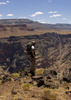
Have you factored in Schultz ridge? Because that 10,000' ridge line is guaranteed to block any views of a sunrise from the south slope of the Peaks. The sun will be rising right at 100 degrees, with 90 being due east and 100 being a little south of that, so you may want to hike up the Kachina into some of the large meadows (that use to be much larger before the aspen took over after fire cessation) and view the rise from there.
Last edited by Jim on Sep 28 2010 8:28 pm, edited 1 time in total.
contribute to this member driven resource
ie: RS > Save/Share after hikes
-
hippiepunkpirateGuides: 25 | Official Routes: 23Triplogs Last: 499 d | RS: 0Water Reports 1Y: 0 | Last: 3,872 d
- Joined: May 30 2008 7:43 am
- City, State: Peoria, AZ
- Contact:
Re: HAZ Fall Photo Workshop
We're planning to scout sunrise shooting within the week prior to check out the lighting situation on the Kachina. Joel, I'd think getting up that early we might want to leave for Kachina without breaking camp, because we'd have to get up even early in order to break camp. Then we could all pile into HC vehicles at camp without having to switch later, then return and break camp after the sunrise shoot. Agree or disagree?
contribute to this member driven resource
ie: RS > Save/Share after hikes
-
JoelHazeltonGuides: 16 | Official Routes: 1Triplogs Last: 143 d | RS: 1Water Reports 1Y: 2 | Last: 303 d
- Joined: Mar 22 2006 7:45 am
- City, State: Phoenix, AZ
- Contact:
Re: HAZ Fall Photo Workshop
Good call. Personally, I'll probably just crash in the back of my truck. If I'm freezing my butt off when I sleep, it'll make it easier to get up in the morning.hippiepunkpirate wrote:We're planning to scout sunrise shooting within the week prior to check out the lighting situation on the Kachina. Joel, I'd think getting up that early we might want to leave for Kachina without breaking camp, because we'd have to get up even early in order to break camp. Then we could all pile into HC vehicles at camp without having to switch later, then return and break camp after the sunrise shoot. Agree or disagree?
"Arizona is the land of contrast... You can go from Minnesota to California in a matter of minutes, then have Mexican food that night." -Jack Dykinga
http://www.joelhazelton.com
http://www.joelhazelton.com
contribute to this member driven resource
ie: RS > Save/Share after hikes
-
chumleyGuides: 94 | Official Routes: 239Triplogs Last: 3 d | RS: 73Water Reports 1Y: 95 | Last: 2 d
- Joined: Sep 18 2002 8:59 am
- City, State: Tempe, AZ
Re: HAZ Fall Photo Workshop
I find that the best sunrises occur in the hours shortly before going to sleep...azpride wrote:I know 4AM is a real early getup time... It's a battle every time I get up for a sunrise shoot, but it's always worthwhile. Early morning sun backlighting yellow aspen leaves will be AMAZING.
I'm not sure what my spirit animal is, but I'm confident it has rabies.
contribute to this member driven resource
ie: RS > Save/Share after hikes
-
JoelHazeltonGuides: 16 | Official Routes: 1Triplogs Last: 143 d | RS: 1Water Reports 1Y: 2 | Last: 303 d
- Joined: Mar 22 2006 7:45 am
- City, State: Phoenix, AZ
- Contact:
Re: HAZ Fall Photo Workshop
I'm definitely considering that for this trip...chumley wrote:I find that the best sunrises occur in the hours shortly before going to sleep...azpride wrote:I know 4AM is a real early getup time... It's a battle every time I get up for a sunrise shoot, but it's always worthwhile. Early morning sun backlighting yellow aspen leaves will be AMAZING.
"Arizona is the land of contrast... You can go from Minnesota to California in a matter of minutes, then have Mexican food that night." -Jack Dykinga
http://www.joelhazelton.com
http://www.joelhazelton.com
contribute to this member driven resource
ie: RS > Save/Share after hikes
-
JonnybackpackGuides: 0 | Official Routes: 0Triplogs Last: 3,709 d | RS: 0Water Reports 1Y: 0 | Last: 4,525 d
- Joined: May 30 2008 10:17 pm
- City, State: queen creek, az
- Contact:
Re: HAZ Fall Photo Workshop
Great news.... after this gross high pressure system moves out of the SW, a new system of low pressure moves in sometime Sunday evening. This will probably mean the first freeze around the peaks which, of course, is A much needed occurance for those fall colors! I'll admit i was getting worried 
contribute to this member driven resource
ie: RS > Save/Share after hikes
-
jdsteeleGuides: 0 | Official Routes: 1Triplogs Last: 5,770 d | RS: 0Water Reports 1Y: 0 | Last: never
- Joined: Sep 26 2007 2:36 pm
- City, State: Scottsdale, AZ
Re: HAZ Fall Photo Workshop
Yes, i was getting worried that it might be too warm for camping.Jonnybackpack wrote:Great news.... after this gross high pressure system moves out of the SW, a new system of low pressure moves in sometime Sunday evening. This will probably mean the first freeze around the peaks which, of course, is A much needed occurance for those fall colors! I'll admit i was getting worried
If Lori comes up with me, she probably won't be interested in waking at 4am (at 30 degrees), are other spouses/friends interested in hanging around camp while the photogs do the sunrise shoot?
BTW: I'm still slightly on the fence about a final commit, but I have a 2WD moderately high clearance SUV (Montero Sport) that will be available for carpooling to/from camp.
contribute to this member driven resource
ie: RS > Save/Share after hikes
-
JimGuides: 76 | Official Routes: 39Triplogs Last: 31 d | RS: 93Water Reports 1Y: 6 | Last: 43 d
- Joined: Sep 08 2006 8:14 pm
Re: HAZ Fall Photo Workshop
Speak for yourselves, Valley dwellers. This awesome beautiful high pressure is lovely. I hope this will keep on being like it is until well after Hazoween. Color? Eh, who cares? Thats my feeling. I would much rather have these record warm 80 degree days than cold and color. The way I see it, color is the pleasant side affect of the cold, but still something I can do without. Too warm for camping? Ha! It still gets down into the 40s at night, so you'll be plenty cold at 4am. Remember, you'll be up at almost 8,000' so it won't stay warm once the sun goes down.
BTW, there have already been freezes on and around the Peaks according to some HAZers.
BTW, there have already been freezes on and around the Peaks according to some HAZers.
contribute to this member driven resource
ie: RS > Save/Share after hikes