 Route Editor

We found this trail sign while hiking in East Clear Creek:
There was an old road near it and some signs of campsites around it but it was in a fairly inaccessible location. Trail 108 is the West Fork of Oak Creek Trail, and "V V" is a ranch somewhere here in Arizona but I don't know where. This was the only sign we found in the canyon and there were no blazes to further define the trail. Any ideas?
HAZ VV Map
VV Trail Sign
Moderator: HAZ - Moderators
Linked Area, etc none
-
 mttgilbertGuides: 5 | Official Routes: 0Triplogs Last: 6,219 d | RS: 0Water Reports 1Y: 0 | Last: 6,414 d
 - Joined: Oct 14 2002 3:40 pm
- City, State: Denver, CO
VV Trail Sign
-Matt Gilbert
contribute to this member driven resource
ie: RS > Save/Share after hikes 

-
 chumleyGuides: 94 | Official Routes: 239Triplogs Last: 3 d | RS: 73Water Reports 1Y: 95 | Last: 2 d
 - Joined: Sep 18 2002 8:59 am
- City, State: Tempe, AZ
Re: Trail Sign
I created a label to keep them together. While there are currently 7 photos, I believe there are only 5 unique signs currently identified.
I'm not sure what my spirit animal is, but I'm confident it has rabies.
contribute to this member driven resource
ie: RS > Save/Share after hikes
-
 big_loadGuides: 0 | Official Routes: 1Triplogs Last: 507 d | RS: 3Water Reports 1Y: 0 | Last: 2,710 d
 - Joined: Oct 28 2003 11:20 am
- City, State: Andover, NJ
Re: Trail Sign
My current best guess is an obsolete OHV or snowmobile trail sign. I'm more interested now in how long it will be before somebody breaks down and asks the USFS. 
contribute to this member driven resource
ie: RS > Save/Share after hikes
-
chumleyGuides: 94 | Official Routes: 239Triplogs Last: 3 d | RS: 73Water Reports 1Y: 95 | Last: 2 d
- Joined: Sep 18 2002 8:59 am
- City, State: Tempe, AZ
Re: Trail Sign
@big_load
Well Outdoor Lover has already asked, and Tough_boots has too. Getting the correct answer has so far proven elusive.
BTW I don't think your old OHV sign theory makes sense. There are no roads on the old travel management map (the one that inventoried all the roads so they could determine which to close and which to keep open) near the signs we have identified -- and I don't think OHV was even a thing when these signs were put up!
I'm not sure what my spirit animal is, but I'm confident it has rabies.
contribute to this member driven resource
ie: RS > Save/Share after hikes
-
big_loadGuides: 0 | Official Routes: 1Triplogs Last: 507 d | RS: 3Water Reports 1Y: 0 | Last: 2,710 d
- Joined: Oct 28 2003 11:20 am
- City, State: Andover, NJ
Re: VV Trail Sign
@chumley Well, not OHV in the modern sense, but more like dirt bikes. If the USFS doesn't know what they are, I wonder what would happen if you asked to remove them.
contribute to this member driven resource
ie: RS > Save/Share after hikes
-
 whaGuides: 0 | Official Routes: 0Triplogs Last: 3,291 d | RS: 0Water Reports 1Y: 0 | Last: 3,355 d
 - Joined: Feb 10 2012 10:57 pm
- City, State: Arizona
Re: Trail Sign
VV = Verified Vertical Elevationchumley wrote:Quick search shows that VVH is a surveying acronym for "Verified Vertical Horizontal". I don't see any surveying use of "Verfied Vertical" alone however.
VVH = Verified Vertical Elevation and Horizontal Location
contribute to this member driven resource
ie: RS > Save/Share after hikes
-
big_loadGuides: 0 | Official Routes: 1Triplogs Last: 507 d | RS: 3Water Reports 1Y: 0 | Last: 2,710 d
- Joined: Oct 28 2003 11:20 am
- City, State: Andover, NJ
Re: VV Trail Sign
Did anyone ask the USGS?
contribute to this member driven resource
ie: RS > Save/Share after hikes
-
 The_EagleGuides: 42 | Official Routes: 365Triplogs Last: 6 d | RS: 762Water Reports 1Y: 76 | Last: 14 d
 - Joined: Jan 20 2009 2:46 pm
- City, State: Far NE Phoenix, Az
- Contact:
Re: VV Trail Sign
Geocoded map updated to show all 5 -> http://hikearizona.com/map.php?MY=14051&M=6
There is a very fine line between "hobby" and "mental illness."
Dave Barry
Dave Barry

contribute to this member driven resource
ie: RS > Save/Share after hikes
-
chumleyGuides: 94 | Official Routes: 239Triplogs Last: 3 d | RS: 73Water Reports 1Y: 95 | Last: 2 d
- Joined: Sep 18 2002 8:59 am
- City, State: Tempe, AZ
Re: VV Trail Sign
I sent an email to bho@whitehouse.govbig_load wrote:Did anyone ask the USGS?
I'll let you know when I get a response.
Oh hold on, there's somebody knocking at the door...
I'm not sure what my spirit animal is, but I'm confident it has rabies.
contribute to this member driven resource
ie: RS > Save/Share after hikes
-
big_loadGuides: 0 | Official Routes: 1Triplogs Last: 507 d | RS: 3Water Reports 1Y: 0 | Last: 2,710 d
- Joined: Oct 28 2003 11:20 am
- City, State: Andover, NJ
Re: VV Trail Sign
You should have used someone else's computer.
I can't find any sort of signage associated with that particular surveying terminology. However, the terms themselves seem to appear frequently with regard to buried utilities in reports.
I can't find any sort of signage associated with that particular surveying terminology. However, the terms themselves seem to appear frequently with regard to buried utilities in reports.
contribute to this member driven resource
ie: RS > Save/Share after hikes
-
 outdoor_loverGuides: 7 | Official Routes: 6Triplogs Last: 110 d | RS: 2Water Reports 1Y: 29 | Last: 123 d
 - Joined: Aug 19 2011 7:49 pm
- City, State: Scottsdale, AZ
Re: VV Trail Sign
Hank posted 1 in Bear, but I think there were at least two down there. I got Photos of them also and there was some discussion then. I think Hank even emailed the Forest Service about them and never got a Reply? ( I would Paste the Link but I don't know how with my "Pimp Phone") (bartel label lol)
Life is not a journey to the grave with the intention of arriving safely in a pretty & well preserved body, but rather to skid in broadside, totally worn out & proclaiming, "Wow What a Ride!"
contribute to this member driven resource
ie: RS > Save/Share after hikes
-
 GrasshopperGuides: 48 | Official Routes: 143Triplogs Last: 314 d | RS: 0Water Reports 1Y: 0 | Last: 1,039 d
 - Joined: Dec 28 2006 5:06 pm
- City, State: Scottsdale, AZ
Re: VV Trail Sign
@Outdoor Lover Yes & I re-posted your 6/23/12 sign pic here--> http://hikearizona.com/photo.php?ID=509788
(Outside.. "there is No Place Like It!!")
contribute to this member driven resource
ie: RS > Save/Share after hikes
-
big_loadGuides: 0 | Official Routes: 1Triplogs Last: 507 d | RS: 3Water Reports 1Y: 0 | Last: 2,710 d
- Joined: Oct 28 2003 11:20 am
- City, State: Andover, NJ
Re: VV Trail Sign
I think the numbers on the signs are interesting. They're too low to represent measurements of any precision. They must be indices that refer to data held elsewhere (as a road number for example).
contribute to this member driven resource
ie: RS > Save/Share after hikes
-
 Alston_NealGuides: 1 | Official Routes: 0Triplogs Last: 155 d | RS: 0Water Reports 1Y: 0 | Last: never
 - Joined: Apr 19 2008 5:53 pm
- City, State: Phoenix, AZ
Re: VV Trail Sign
I think the bigger mystery is why Chums hasn't hijacked this thread in 7 years...JK
I've seen these signs also but never gave them much thought till now. Their construction shows them to not be considered temporary, or some Government funded project. They appear to be from the late 50's 60's and could coincide with the time of heavy logging up there.
I've seen these signs also but never gave them much thought till now. Their construction shows them to not be considered temporary, or some Government funded project. They appear to be from the late 50's 60's and could coincide with the time of heavy logging up there.
contribute to this member driven resource
ie: RS > Save/Share after hikes
-
 joebartelsGuides: 264 | Official Routes: 224Triplogs Last: 7 d | RS: 2063Water Reports 1Y: 28 | Last: 11 d
 - Joined: Nov 20 1996 12:00 pm
contribute to this member driven resource
ie: RS > Save/Share after hikes
-
The_EagleGuides: 42 | Official Routes: 365Triplogs Last: 6 d | RS: 762Water Reports 1Y: 76 | Last: 14 d
- Joined: Jan 20 2009 2:46 pm
- City, State: Far NE Phoenix, Az
- Contact:
Re: VV Trail Sign
The one we recorded yesterday, is the most northern one so far.
I've updated the locations on the master.
http://hikearizona.com/map.php?MY=14051&M=6
One of these days.....
I've updated the locations on the master.
http://hikearizona.com/map.php?MY=14051&M=6
One of these days.....
There is a very fine line between "hobby" and "mental illness."
Dave Barry
Dave Barry
contribute to this member driven resource
ie: RS > Save/Share after hikes
-
 rcorfmanGuides: 1 | Official Routes: 4Triplogs Last: 665 d | RS: 2Water Reports 1Y: 0 | Last: 1,116 d
 - Joined: Oct 17 2008 11:19 pm
- City, State: Phoenix, AZ
- Contact:
Re: VV Trail Sign
So I take it this one isn't on the list? I think it's a couple hundred feet upstream from where the U-Bar trail crosses Barbershop Canyon.
Go find a LonelyCache
contribute to this member driven resource
ie: RS > Save/Share after hikes
-
The_EagleGuides: 42 | Official Routes: 365Triplogs Last: 6 d | RS: 762Water Reports 1Y: 76 | Last: 14 d
- Joined: Jan 20 2009 2:46 pm
- City, State: Far NE Phoenix, Az
- Contact:
Re: VV Trail Sign
There is a very fine line between "hobby" and "mental illness."
Dave Barry
Dave Barry
contribute to this member driven resource
ie: RS > Save/Share after hikes
-
rcorfmanGuides: 1 | Official Routes: 4Triplogs Last: 665 d | RS: 2Water Reports 1Y: 0 | Last: 1,116 d
- Joined: Oct 17 2008 11:19 pm
- City, State: Phoenix, AZ
- Contact:
Re: VV Trail Sign
@The_Eagle
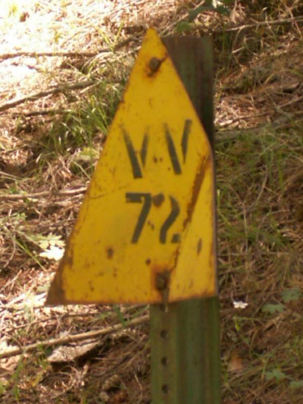
No, closer to 34.493167 -111.164617. It was downstream a short distance from a geocache at those coordinates. I don't remember how far away, probably less than 50'. That's not my picture either, it was posted by another finder of the geocache. Part of the hint for the geocache is, "When you reach VV72, you are getting close!"
No, closer to 34.493167 -111.164617. It was downstream a short distance from a geocache at those coordinates. I don't remember how far away, probably less than 50'. That's not my picture either, it was posted by another finder of the geocache. Part of the hint for the geocache is, "When you reach VV72, you are getting close!"
Go find a LonelyCache
contribute to this member driven resource
ie: RS > Save/Share after hikes
-
chumleyGuides: 94 | Official Routes: 239Triplogs Last: 3 d | RS: 73Water Reports 1Y: 95 | Last: 2 d
- Joined: Sep 18 2002 8:59 am
- City, State: Tempe, AZ
Re: VV Trail Sign
Map and label are updated with rcorfman's VV 72. I also added the photo to one of my photosets just so it's got a PID on site somewhere.
I included another triangle on the rim posted by Kingsnake a year ago. It doesn't have a VV and may be unrelated. But just for reference and the potential link, I included it.
And technically the one at Kinder Crossing is also unidentified as to whether there is a VV or not.
As far as I can tell, there is only one sign we have found that has both up and down triangles, with a VVH on bottom and a VV on top.
The mystery continues...
http://hikearizona.com/map.php?MY=21909&M=6
I'm not sure what my spirit animal is, but I'm confident it has rabies.
contribute to this member driven resource
ie: RS > Save/Share after hikes
-
big_loadGuides: 0 | Official Routes: 1Triplogs Last: 507 d | RS: 3Water Reports 1Y: 0 | Last: 2,710 d
- Joined: Oct 28 2003 11:20 am
- City, State: Andover, NJ
Re: VV Trail Sign
Do they mark where the aliens laid their eggs?
contribute to this member driven resource
ie: RS > Save/Share after hikes