 Route Editor

Sunday, February 24, 2013
7:00 AM
Fort McDowell Casino, This is just north of 87 (Beeline)
10438 N Fort Mcdowell Road , Fort McDowell, AZ
Meet up at Fort McDowell Casino, 6:45 to 7AM.
7AM, drive North on Highway 87; 12 Miiles to FOUR PEAKS ROAD. Take FOUR PEAKS ROAD 15.1 Miles to the MUD SPRINGS TRAILHEAD
Those with cars or a low profile vehicle are recommended to carpool from the meetup spot. Four Peaks road is a rugged path for high profile vehicles only.
This hike goes up 4.22 miles then back; 8.44 cumulative hike miles. There is 6300' in cumulative Elevation Gain. The first few miles are fairly easy; once we hit the peaks, there is some non-technical rock climbing.
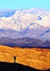
Four Peaks, at 7657 ft in altitude, is a prominent landmark on the eastern skyline of Phoenix, part of the Mazatzal Mountains. It is located in the Tonto National Forest 40 mi east-northeast of Phoenix, in the 60740 acre Four Peaks Wilderness. On rare occasions, Four Peaks offers much of the Phoenix metro area a view of snow covered peaks, and is the highest point in Maricopa County.
Google Earth 3D Flyover of the peaks:
http://mw1.google.com/mw-earth-vectordb ... a323e4.kmz
Peter Medal
602-469-7400
meetup http://www.meetup.com/TLC-Hiking-Group/ ... 104260572/
Four Peaks Ridgeline Traverse 8.44 Miles 6800' elevation gai
Moderators: HAZ Group Coordinators, HAZ - Moderators
-
 Peter_MedalGuides: 9 | Official Routes: 7Triplogs Last: 534 d | RS: 5Water Reports 1Y: 0 | Last: 2,720 d
 - Joined: Feb 19 2013 9:51 am
- City, State: Prescott, AZ
Four Peaks Ridgeline Traverse 8.44 Miles 6800' elevation gai
"Before there was a trail..... there was no trail"
contribute to this member driven resource
ie: RS > Save/Share after hikes 

-
 nonotGuides: 107 | Official Routes: 108Triplogs Last: 108 d | RS: 0Water Reports 1Y: 9 | Last: 108 d
 - Joined: Nov 18 2005 11:52 pm
- City, State: Phoenix, AZ
Re: Four Peaks Ridgeline Traverse 8.44 Miles 6800' elevation
I think enough responses have been made to warn these folks about the poor conditions they should expect. Hopefully they will plan appropriately, or revise their plans.
If any of the original posters are still following - don't get upset by everybody chipping on your plans - there are a large number of "bad ideas" that this forum sees posted by people completely unaware and incapable of performing what they are asking about. So as a result, a few warning serve their purpose - to persuade people away from a bad idea. If your group is very experienced and capable of performing this trip as planned, kudos to you. I have always wanted to get into technical mountaineering, which is more along the lines of what this trip will be like at this time of year. Hope you continue to share your adventures with hikeaz in the future.
If any of the original posters are still following - don't get upset by everybody chipping on your plans - there are a large number of "bad ideas" that this forum sees posted by people completely unaware and incapable of performing what they are asking about. So as a result, a few warning serve their purpose - to persuade people away from a bad idea. If your group is very experienced and capable of performing this trip as planned, kudos to you. I have always wanted to get into technical mountaineering, which is more along the lines of what this trip will be like at this time of year. Hope you continue to share your adventures with hikeaz in the future.
http://hikearizona.com/garmin_maps.php
Hike Arizona it is full of sharp, pointy, ankle-twisting, HAZmaster crushing ROCKS!!
Hike Arizona it is full of sharp, pointy, shin-stabbing, skin-shredding plants!
Hike Arizona it is full of striking, biting, stabbing, venomous wildlife!
Hike Arizona it is full of sharp, pointy, ankle-twisting, HAZmaster crushing ROCKS!!
Hike Arizona it is full of sharp, pointy, shin-stabbing, skin-shredding plants!
Hike Arizona it is full of striking, biting, stabbing, venomous wildlife!
contribute to this member driven resource
ie: RS > Save/Share after hikes
-
 rally_toadGuides: 22 | Official Routes: 3Triplogs Last: 1,055 d | RS: 60Water Reports 1Y: 0 | Last: never
 - Joined: May 17 2007 8:06 pm
- City, State: CA
Re: Four Peaks Ridgeline Traverse 8.44 Miles 6800' elevation
I understand that the itinerary for the trip changed, but it seemed as though some were insulted that we would even question the safety of this trip at this time of year. What is the point of being so defensive? We simply don't want to see this turned into a news story. We aren't attacking someone's ability as a hiker. We are simply questioning the choice to hike the Motherlode in snowy, icy conditions when this can be a dangerous hike in good conditions. We want people to be safe. We aren't attacking their abilities.
"Who are you guys??!!" -Farnsworth
contribute to this member driven resource
ie: RS > Save/Share after hikes
-
 Tough_BootsGuides: 0 | Official Routes: 6Triplogs Last: 2,684 d | RS: 20Water Reports 1Y: 0 | Last: 2,824 d
 - Joined: Mar 28 2008 7:08 pm
- City, State: Phoenix, AZ
Re: Four Peaks Ridgeline Traverse 8.44 Miles 6800' elevation
Just the fact that me and rally_toad agree on this should be reason to question it. I mean-- we did battle opposite sides in one of the most legendary fights in HAZ history 
contribute to this member driven resource
ie: RS > Save/Share after hikes
-
 DarthStillerGuides: 27 | Official Routes: 29Triplogs Last: 2 d | RS: 152Water Reports 1Y: 0 | Last: 4,475 d
 - Joined: Jul 05 2006 12:36 pm
- City, State: Mesa, AZ
Re: Four Peaks Ridgeline Traverse 8.44 Miles 6800' elevation
@Tough_Boots
Yeah, I was noticing that earlier today and hesitated to mention it in fear of hi-jacking the thread.
But I didn't get the impression that anyone was really insulted. Mr. Medal still has yet to respond at all in this forum. Mr. louie just seems to have tried to clarify the communication gap. I can see how the wording of the original post comes across as complacent, but from there, I think these guys are knowledgeable, capable, and too busy to respond to be insulted.
contribute to this member driven resource
ie: RS > Save/Share after hikes
-
Peter_MedalGuides: 9 | Official Routes: 7Triplogs Last: 534 d | RS: 5Water Reports 1Y: 0 | Last: 2,720 d
- Joined: Feb 19 2013 9:51 am
- City, State: Prescott, AZ
Re: Four Peaks Ridgeline Traverse 8.44 Miles 6800' elevation
Wow, I just joined this group....feel like a bull in a china shop. Hopefully will not be banned or discharged from the group.
thanks for the warnings ...my crew and I will be fine.... the excursion has been modified to simply start from Mud Springs over to the west ridgeline and work it east towards Browns Peak for just 2.5 hours...if we summit, sweet, if not, then turnaround...bust...ohh well, better luck next time. I heard the cash game at Fort McDowell is pretty juicy Sunday afternoons, so I am just doing this as a Mt. Whitney training hike for my crew and hope to clean up off the donk tards at the poker tables. In terms of my sanity.... for the record I am not wired properly. I am a can short of a six pack. I live at 7100' in Walker, AZ... Mt. Union, Mt. Davis, Mt. Tritle, Big Bug Mesa, Grapevine falls/canyon, Spruce Mountain...they are all in my backyard and are used as such. I drive in mountainous snow conditions (have chains and use them regularly so no worries there). I snow hike all the time; peak camping at -5 degrees; ... ..should blizzard conditions hit, I cant tent out for as long as we need. ... How about a LIKE yo's.
thanks for the warnings ...my crew and I will be fine.... the excursion has been modified to simply start from Mud Springs over to the west ridgeline and work it east towards Browns Peak for just 2.5 hours...if we summit, sweet, if not, then turnaround...bust...ohh well, better luck next time. I heard the cash game at Fort McDowell is pretty juicy Sunday afternoons, so I am just doing this as a Mt. Whitney training hike for my crew and hope to clean up off the donk tards at the poker tables. In terms of my sanity.... for the record I am not wired properly. I am a can short of a six pack. I live at 7100' in Walker, AZ... Mt. Union, Mt. Davis, Mt. Tritle, Big Bug Mesa, Grapevine falls/canyon, Spruce Mountain...they are all in my backyard and are used as such. I drive in mountainous snow conditions (have chains and use them regularly so no worries there). I snow hike all the time; peak camping at -5 degrees; ... ..should blizzard conditions hit, I cant tent out for as long as we need. ... How about a LIKE yo's.
"Before there was a trail..... there was no trail"
contribute to this member driven resource
ie: RS > Save/Share after hikes
-
 outdoor_loverGuides: 7 | Official Routes: 6Triplogs Last: 110 d | RS: 2Water Reports 1Y: 29 | Last: 123 d
 - Joined: Aug 19 2011 7:49 pm
- City, State: Scottsdale, AZ
Re: Four Peaks Ridgeline Traverse 8.44 Miles 6800' elevation
@Peter Medal
Let us know how it goes...You can post a triplog and Photos on this site too....
Let us know how it goes...You can post a triplog and Photos on this site too....
Life is not a journey to the grave with the intention of arriving safely in a pretty & well preserved body, but rather to skid in broadside, totally worn out & proclaiming, "Wow What a Ride!"
contribute to this member driven resource
ie: RS > Save/Share after hikes
-
Peter_MedalGuides: 9 | Official Routes: 7Triplogs Last: 534 d | RS: 5Water Reports 1Y: 0 | Last: 2,720 d
- Joined: Feb 19 2013 9:51 am
- City, State: Prescott, AZ
Re: Four Peaks Ridgeline Traverse 8.44 Miles 6800' elevation
after 2 hours, just made it about 150' feet below the west ridgeline, then had to turnaround....boo! Want to bag and tag the 1,2,3,4,3,2,1 but with an overnight camping at the base of the peaks...making it a 2 day excursion, perhaps in March. Very impressed with the ROAD. Last time I was here was 20+ years ago and the road was much thinner and more rugged. Was amazed at the volume of off roaders on the road.
"Before there was a trail..... there was no trail"
contribute to this member driven resource
ie: RS > Save/Share after hikes
-
 chumleyGuides: 94 | Official Routes: 239Triplogs Last: 3 d | RS: 73Water Reports 1Y: 95 | Last: 2 d
 - Joined: Sep 18 2002 8:59 am
- City, State: Tempe, AZ
Re: Four Peaks Ridgeline Traverse 8.44 Miles 6800' elevation
Sounds like fun Peter. Please share a triplog and photos if you have any. (black post button, top upper left of any page)
I'm not sure what my spirit animal is, but I'm confident it has rabies.
contribute to this member driven resource
ie: RS > Save/Share after hikes
-
Peter_MedalGuides: 9 | Official Routes: 7Triplogs Last: 534 d | RS: 5Water Reports 1Y: 0 | Last: 2,720 d
- Joined: Feb 19 2013 9:51 am
- City, State: Prescott, AZ
Re: Four Peaks Ridgeline Traverse 8.44 Miles 6800' elevation
I am a loser, I dont have a GPS to share a log  but when I do this again, for real, will make sure I have one.
"Before there was a trail..... there was no trail"
contribute to this member driven resource
ie: RS > Save/Share after hikes
-
outdoor_loverGuides: 7 | Official Routes: 6Triplogs Last: 110 d | RS: 2Water Reports 1Y: 29 | Last: 123 d
- Joined: Aug 19 2011 7:49 pm
- City, State: Scottsdale, AZ
Re: Four Peaks Ridgeline Traverse 8.44 Miles 6800' elevation
@Peter Medal
No one is a loser here.... You don't need a GPS Route in order to share a triplog and Photoset. Or just a triplog, or just a Photoset...I've been doing triplogs on here for well over a year and still don't have a GPS....  If you need help with doing a triplog, you can PM the Webmaster for help or any of us winners and we'll be glad to help you....If you want I'll even do it over the phone and talk you through it....
No one is a loser here....
Life is not a journey to the grave with the intention of arriving safely in a pretty & well preserved body, but rather to skid in broadside, totally worn out & proclaiming, "Wow What a Ride!"
contribute to this member driven resource
ie: RS > Save/Share after hikes
-
 ASUAviatorGuides: 1 | Official Routes: 2Triplogs Last: 3,263 d | RS: 0Water Reports 1Y: 0 | Last: 3,326 d
 - Joined: Nov 06 2010 12:12 pm
- City, State: Phoenix, AZ
Re: Four Peaks Ridgeline Traverse 8.44 Miles 6800' elevation
I love that area, my uncle used to have a cabin in Groom Creek and I spent alot of time getting to know those mountains. Lots to discover there. I found a stolen car from califonia on the back side of Tritle when I was 15. Pretty sketchy. Im gonna buy that cabin back someday. Wish he never sold it.Peter Medal wrote:I live at 7100' in Walker, AZ... Mt. Union, Mt. Davis, Mt. Tritle, Big Bug Mesa, Grapevine falls/canyon, Spruce Mountain...
contribute to this member driven resource
ie: RS > Save/Share after hikes
-
 RickVincentGuides: 4 | Official Routes: 3Triplogs Last: 542 d | RS: 0Water Reports 1Y: 0 | Last: never
 - Joined: Aug 20 2009 9:57 am
- City, State: Mesa, AZ
Re: Four Peaks Ridgeline Traverse 8.44 Miles 6800' elevation
Hey there's always Salome Jug in March. Bet the water is ripping through there about this time. Would definitely be one for the thrillseekers.
This is my gym. I have to travel down a bumpy road to get there. There are no treadmillls, no machines, and no personal trainers. I walk..I run..I breathe the fresh air. I can go any time I want, as much as I want and there is no membership fee.
contribute to this member driven resource
ie: RS > Save/Share after hikes
-
outdoor_loverGuides: 7 | Official Routes: 6Triplogs Last: 110 d | RS: 2Water Reports 1Y: 29 | Last: 123 d
- Joined: Aug 19 2011 7:49 pm
- City, State: Scottsdale, AZ
Re: Four Peaks Ridgeline Traverse 8.44 Miles 6800' elevation
I may have to try and invest in a wetsuit....
Life is not a journey to the grave with the intention of arriving safely in a pretty & well preserved body, but rather to skid in broadside, totally worn out & proclaiming, "Wow What a Ride!"
contribute to this member driven resource
ie: RS > Save/Share after hikes