 Route Editor

My wife and I are going to be taking my parents on their first backpacking trip. They'll be visiting over Thanksgiving and we'll just be going for an overnight. I need some suggestions for the trip since I'm more familiar with the higher elevation trips and its getting a bit cold on the rim. My wife would also like to avoid the Superstitions since we have been there quite a bit. I want to keep it 5 to 7 miles each way and camp on or near water, also would like to be able to have a campfire. This will make it a lot more enjoyable for them and keep our packs lighter. I was hoping to find something in Sedona, with my fallback being West Fork of Oak Creek. All I came up with was Mooney trail, and the camp sites were only about 3 miles in. Any other good hikes in Sedona that will have water and allow fires?
I'm not too familar with the Matazals but it does not seem like there is a lot of water to be had. Anyway, all ideas are welcome. Thanks.
1st time backpack over Thx Giving.
Moderator: HAZ - Moderators
Linked Guides none
Linked Area, etc none
-
 Xiled1Guides: 0 | Official Routes: 0Triplogs Last: 2,168 d | RS: 0Water Reports 1Y: 0 | Last: 5,518 d
 - Joined: Feb 26 2009 10:59 am
- City, State: Mesa, AZ
contribute to this member driven resource
ie: RS > Save/Share after hikes 

-
 nonotGuides: 107 | Official Routes: 108Triplogs Last: 116 d | RS: 0Water Reports 1Y: 9 | Last: 116 d
 - Joined: Nov 18 2005 11:52 pm
- City, State: Phoenix, AZ
Re: 1st time backpack over Thx Giving.
Not exactly Sedona, but maybe you could go down into Sycamore Canyon on either Dogie or Sycamore?
Most trails in Sedona don't go that far from the road, but the longer ones appear to be:
Jack's Canyon
Brins Mesa
Loy Canyon
Boyton Canyon
Secret Canyon
Note: I have no (or very limited) experience with these trails. I haven't checked if campfires are allowed in the red rock area.
One I have done that probably isn't too conducive to parents is Woods Canyon, I don't recommend this based on the amount of boulder hopping and your other backpacking partners.
http://hikearizona.com/garmin_maps.php
Hike Arizona it is full of sharp, pointy, ankle-twisting, HAZmaster crushing ROCKS!!
Hike Arizona it is full of sharp, pointy, shin-stabbing, skin-shredding plants!
Hike Arizona it is full of striking, biting, stabbing, venomous wildlife!
Hike Arizona it is full of sharp, pointy, ankle-twisting, HAZmaster crushing ROCKS!!
Hike Arizona it is full of sharp, pointy, shin-stabbing, skin-shredding plants!
Hike Arizona it is full of striking, biting, stabbing, venomous wildlife!
contribute to this member driven resource
ie: RS > Save/Share after hikes
-
Xiled1Guides: 0 | Official Routes: 0Triplogs Last: 2,168 d | RS: 0Water Reports 1Y: 0 | Last: 5,518 d
- Joined: Feb 26 2009 10:59 am
- City, State: Mesa, AZ
Re: 1st time backpack over Thx Giving.
Thanks for the suggestions. The hard part is finding out if there is water in those canyons. Trying to do a little searching around find out. But if they do, its most likely only in spring. You can have campfires in The RR Wilderness, but its got to be outside the high traffic areas. The pink area on their map.
Any othe suggestions are welcome even if not in Sedona.
The Dogie Looks great, but I'm assuming ZERO chance of water this time of year.
Any othe suggestions are welcome even if not in Sedona.
The Dogie Looks great, but I'm assuming ZERO chance of water this time of year.
contribute to this member driven resource
ie: RS > Save/Share after hikes
-
 JimGuides: 76 | Official Routes: 39Triplogs Last: 5 d | RS: 94Water Reports 1Y: 7 | Last: 5 d
 - Joined: Sep 08 2006 8:14 pm
Re: 1st time backpack over Thx Giving.
Dogie will be dry or only flowing a very small amount. Plan on dry. Another good area is the Wet Beaver Creek Area and he Bell Trail. Water Galore in the Wet Beaver.
contribute to this member driven resource
ie: RS > Save/Share after hikes
-
Xiled1Guides: 0 | Official Routes: 0Triplogs Last: 2,168 d | RS: 0Water Reports 1Y: 0 | Last: 5,518 d
- Joined: Feb 26 2009 10:59 am
- City, State: Mesa, AZ
Re: 1st time backpack over Thx Giving.
I was thinking about Wet Beaver Creek, but every time I have been there, its been crowded. Usually with youg folks overnighting/paryting. I'd like to get away a little to show my parents some peace and quiet. Although being a holiday weekend, we're likely to run into alot of other hikers. Any spots up the Bell Trail past Wet Beaver that are good for camping? It looks like it just dead ends into a forest road.
contribute to this member driven resource
ie: RS > Save/Share after hikes
-
 juliachaosGuides: 0 | Official Routes: 8Triplogs Last: 3,287 d | RS: 0Water Reports 1Y: 0 | Last: never
 - Joined: Mar 01 2010 11:36 am
- City, State: Phoenix, AZ
- Contact:
Re: 1st time backpack over Thx Giving.
I'll report back to you if I see any water up there this weekend. Like you, I'm expecting dry though..Xiled1 wrote:The Dogie Looks great
contribute to this member driven resource
ie: RS > Save/Share after hikes
-
 hikeazGuides: 6 | Official Routes: 0Triplogs Last: 1,245 d | RS: 0Water Reports 1Y: 0 | Last: 1,245 d
 - Joined: May 13 2002 10:07 am
- City, State: Tempe, AZ
- Contact:
Re: 1st time backpack over Thx Giving.
There is almost always a big pool in the creekbed of Sycamore about 1/4 mile south of Taylor Cabin. From the cabin head south past the corral to the creekbed, then south in the creekbed for about 100 yards. Also, the last time I was down there I took and filled four 7-gallon water jugs that were at the cabin (empty) and returned them filled to the cabin. So, if everyone has followed suit there may even be water in the cabin.juliachaos wrote:I'll report back to you if I see any water up there this weekend. Like you, I'm expecting dry though..Xiled1 wrote:The Dogie Looks great
"The censorship method ... is that of handing the job over to some frail and erring mortal man, and making him omnipotent on the assumption that his official status will make him infallible and omniscient."
George Bernard Shaw
George Bernard Shaw
contribute to this member driven resource
ie: RS > Save/Share after hikes
-
 azbackpackrGuides: 34 | Official Routes: 30Triplogs Last: 42 d | RS: 0Water Reports 1Y: 8 | Last: 52 d
 - Joined: Jan 21 2006 6:46 am
- City, State: Eagar AZ
Re: 1st time backpack over Thx Giving.
There is a closure in Wet Beaver to camping, I do believe. There are a bunch of rules and regs. There is a thread about it somewhere on here. Oh, here is one thread about it: http://www.hikearizona.com/dex2/viewtop ... f=2&t=5535
There is a point of no return unremarked at the time in most lives. Graham Greene The Comedians
A clean house is a sign of a misspent life.
A clean house is a sign of a misspent life.
contribute to this member driven resource
ie: RS > Save/Share after hikes
-
nonotGuides: 107 | Official Routes: 108Triplogs Last: 116 d | RS: 0Water Reports 1Y: 9 | Last: 116 d
- Joined: Nov 18 2005 11:52 pm
- City, State: Phoenix, AZ
Re: 1st time backpack over Thx Giving.
I think camping is no longer allowed on the Bell trail, AFAIK, you have to do some creek hopping/boulder hopping about a mile plus beyond the beavertail to get far enough away where it is "allowed" if I remember right. I haven't heard of the camping spots described as "great", but there are some. It's more of a destination/journey trip.Xiled1 wrote:I was thinking about Wet Beaver Creek, but every time I have been there, its been crowded. Usually with youg folks overnighting/paryting. I'd like to get away a little to show my parents some peace and quiet. Although being a holiday weekend, we're likely to run into alot of other hikers. Any spots up the Bell Trail past Wet Beaver that are good for camping? It looks like it just dead ends into a forest road.
http://hikearizona.com/garmin_maps.php
Hike Arizona it is full of sharp, pointy, ankle-twisting, HAZmaster crushing ROCKS!!
Hike Arizona it is full of sharp, pointy, shin-stabbing, skin-shredding plants!
Hike Arizona it is full of striking, biting, stabbing, venomous wildlife!
Hike Arizona it is full of sharp, pointy, ankle-twisting, HAZmaster crushing ROCKS!!
Hike Arizona it is full of sharp, pointy, shin-stabbing, skin-shredding plants!
Hike Arizona it is full of striking, biting, stabbing, venomous wildlife!
contribute to this member driven resource
ie: RS > Save/Share after hikes
-
Xiled1Guides: 0 | Official Routes: 0Triplogs Last: 2,168 d | RS: 0Water Reports 1Y: 0 | Last: 5,518 d
- Joined: Feb 26 2009 10:59 am
- City, State: Mesa, AZ
Re: 1st time backpack over Thx Giving.
juliachaos wrote:I'll report back to you if I see any water up there this weekend. Like you, I'm expecting dry though..Xiled1 wrote:The Dogie Looks great
Look forward to hearing your report.
Thanks for the info, not sure if my parents will be ready to do a 9 mile hike. First time out and first time with weight on their backs. But I will keep it in mind. Maybe I'll swing up from the Flagstaff side and check out the water situation next weekend.hikeaz wrote:There is almost always a big pool in the creekbed of Sycamore about 1/4 mile south of Taylor Cabin. From the cabin head south past the corral to the creekbed, then south in the creekbed for about 100 yards. Also, the last time I was down there I took and filled four 7-gallon water jugs that were at the cabin (empty) and returned them filled to the cabin. So, if everyone has followed suit there may even be water in the cabin.juliachaos wrote:I'll report back to you if I see any water up there this weekend. Like you, I'm expecting dry though..Xiled1 wrote:The Dogie Looks great
contribute to this member driven resource
ie: RS > Save/Share after hikes
-
juliachaosGuides: 0 | Official Routes: 8Triplogs Last: 3,287 d | RS: 0Water Reports 1Y: 0 | Last: never
- Joined: Mar 01 2010 11:36 am
- City, State: Phoenix, AZ
- Contact:
Re: 1st time backpack over Thx Giving.
Okay, just checked out Dogie for ya this weekend. There are tons of great camping spots, but the best one (IMHO) is about five miles in. There's three campfire rings in that area, and if you go to the very last one there's a cairned route down into the canyon. On the opposite bank there's another campsite and fire ring. There IS water down there -- plenty of it! -- but it's just a pool; no running water. I guess it depends on what you're willing to filter. Will post pictures of it later on today or tomorrow.
contribute to this member driven resource
ie: RS > Save/Share after hikes
-
Xiled1Guides: 0 | Official Routes: 0Triplogs Last: 2,168 d | RS: 0Water Reports 1Y: 0 | Last: 5,518 d
- Joined: Feb 26 2009 10:59 am
- City, State: Mesa, AZ
Re: 1st time backpack over Thx Giving.
Big Thanks for the report. Look forward to checking out the pictures. I can filter the green stuff, just means I have to clean the filter a lot more.
How was the road to the trailhead? I've never been farther than Casner Mtn Rd and I think I could get my car back to there(maybe).
How was the road to the trailhead? I've never been farther than Casner Mtn Rd and I think I could get my car back to there(maybe).
contribute to this member driven resource
ie: RS > Save/Share after hikes
-
juliachaosGuides: 0 | Official Routes: 8Triplogs Last: 3,287 d | RS: 0Water Reports 1Y: 0 | Last: never
- Joined: Mar 01 2010 11:36 am
- City, State: Phoenix, AZ
- Contact:
Re: 1st time backpack over Thx Giving.
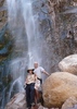
Alrighty, here's a shot of the water. It's not completely clear, but it's not that bad! The camp at the bottom is located at 34.961187, -112.027198. It's warmer in the canyon, but nighttime temps are still pretty chilly. Shouldn't be a problem with a nice blazing campfire though. ;) If you decide on Dogie, enjoy! It's a good one. 
contribute to this member driven resource
ie: RS > Save/Share after hikes