| |
| Everest Base Camp via Gokyo Lakes, WW | | -
-
-
| |  |
|
1 |
-
-
-
-
-
-
-
-
-
-
-
-
|
| | Everest Base Camp via Gokyo Lakes, WW | | | |
|
|
Everest Base Camp via Gokyo Lakes, WW
| | |
|
| Backpack | 60.00 Miles |
13,943 AEG |
| | Backpack | 60.00 Miles | 8 Days | | |
| 13,943 ft AEG | | | | |
|
|
| |
| Linked |
|
none
[ show ]
| no linked trail guides |
| Partners |
|
none
[ show ]
| no partners | | The trip began and ended in colorful Kathmandu, Nepal where we were supposed to take an exciting flight to/from Lukla then ascended to the vast glaciers of the Everest Himalayas. Accommodations along the way were in teahouses and meals were “a la carte,” allowing you the flexibility to eat what you want.
Our trip has pretty full itinerary, which needed to be changed due to weather and record snowfall in Himalayas.
We met Ultimate Everest representative at the airport and drove to the hotel in Kathmandu after arrival.
During this meet and greet the guide discussed the daily activities of the trip.
On the first day of our trek, our flight to Lukla has been cancelled (after hours and hours of waiting at the airport) due to foggy, hazy weather. As we didn't want to miss our days on trail (and didn't know if we will be able to fly next day) we hired a helicopter to take us to Lukla.
Flight to Lukla - Trek to Phakding 8,713 ft / 2,656 m
Enjoyed an exciting flight from Kathmandu to Lukla – this flight is roughly 45 minutes and offers great views of the Everest region. After landing on a steep mountainside runway we met the expedition crew and once the gear was sorted into loads the trek begins. The trail gradually descends on a well-marked trail to Phak Ding, approximately 4 hours of hiking.
Trek to Namche Bazaar 11,318 ft / 3,450 m
We entered the National Park at Monjo as we continued to our next stop, Namche Bazaar, the main trading village in the Khumbu region. The trail crisscrosses the Dudh Kosi (Milk River), these exciting crossing are over suspension bridges that sway high above the valley. The days trek is roughly 4.5 to 6 hours long and once in Namche Bazaar we were free to enjoy coffee, brownie, chocolate doughnut or some other delightful baked goodies (they have awesome bakery with free wifi).
We stayed in tea house called Hill-ton (but it has far to original Hilton hotel, trust me). This was the coldest tea house of them all (no warm fireplace or stove in the common room). Also our rooms were very cold, around 20F.
Namche Bazaar 11,318 ft / 3,450 m *Acclimatization Day*
This day we spent in Namche Bazaar to acclimatize and prepare our bodies to push higher into the Everest region. The village offers shopping opportunities as well as several lodges. It is a great place to spend a day before heading towards Dole.
We hiked few miles uphill to Everest view hotel and back and visited local Sherpa museum before enjoying hot chocolate at local bakery.
Trek to Dole 13,398 ft / 4,084 m
After a nice rest in Namche Bazaar (not really a rest day), we spent this day on a series of switchback trails to the Dudh Kosi River at Phortse Bridge. We headed towards Mon La pass, where the trail climbs steep through rhododendron and birch forest until finally reaching Dole.
Trek to Machermo 14,468 ft / 4,410 m
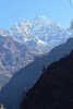
Machermo is a short trek from Dole and the trail climbs steadily hugging the side of the valley. As we trekked higher in elevation the alpine scenery becomes dotted with only small clusters of scrub juniper but the route offers beautiful views of Cho Oyu, Kantega and Thamserku. Once we got to the tea house, it started to snow.
Trek to Gokyo 15,583 ft / 4,750 m
A short steep climb starts the days trek which leads from the Machermo Valley thru the terminal moraines of Ngozumpa Glacier. A steep rocky incline leads into the valley by the side of the glacier and passes the first of the holy lakes. Gokyo is surrounded by stone walled yak pastures and offers a stunning backdrop as Cho Oyu and Gyachung Kang’s massive summits reflect in the emerald green waters.
As it snowed previous day/night, we were forced to hike the trail (no trail really) in deep snow.
Ascent of Gokyo Ri 17,988 ft / 5,483 m and trek to Tragnag 15,387 ft / 4,690 m
The days trek started with a steep climb up Gokyo Ri. This towering peak sits above the village on the northern edge of the lake where panoramic views of Everest, Lhotse and Makalu come into focus.
After this climb we were supposed to navigate our way over Cho La Pass to EBC but we had to change our plans due to too much snow on the trail as the pass become unpassable with high avalanche risk.
Descent to Phortse - this day was spent navigating through deep snow down to Phortse in order to avoid Cho La Pass. Lots of miles in deep snow, avalanche risk, hiking on cliff sides (thank you crampons), wading through blizzard and very cold weather. After dark we reached little village and were able to get rooms in local tea house (they had french fries and Fanta!)
After snowing for 24 hours it became clear that we cant hike any further. Our only solution was to call rescue helicopter.
Our pilot was the same guy who shuttled us to Lukla 10 days ago. The flight was very dangerous (low visibility, falling snow), as our pilot stated 9 on a scale 0-10! We got safely back to Kathmandu a spend the next few days hiking/exploring around.
As we were not able to reach all our goals, we will be back most likely next year, stay tuned!!  |
| _____________________
| | |
|
|
|
|
|
| |
 Route Editor


