|
| | | Harney Peak North Trail, SD | | | |
|
|
Harney Peak North Trail, SD
| | |
| |
|
| Hiking | 9.40 Miles |
2,142 AEG |
| | Hiking | 9.40 Miles | 4 Hrs 30 Mns | | 2.09 mph |
| 2,142 ft AEG | | | | |
|
|
| |
| Partners |
|
none
[ show ]
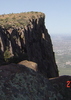
| no partners | | After entering the Black Hills of South Dakota I traveled south from Deadwood to Hill City and then Custer. I spent the night in Custer intending to have a nice relaxing hike on Friday to Harney Peak from the Sylvan Lake Trailhead in Custer State Park. The State Park wanted money to use the trailhead($5!), so I opted instead to travel north to the Willow Creek Trailhead off of SR 244, east of Hill City and west of the Pine Creek Lake on our HAZ Traildex map. I should have paid to use the state park trailhead. The trail was fine, but it was 93 degrees in Hill City when I got back there at 5pm, and the dew point was in the low to middle 60s that day. It must have been a few degrees hotter when I was out hiking. It was unbearably hot, and it made what should have been a relaxing hike into a miserable one. Still, it was better than the 106 degree hike I took on Squaw Peak a few weeks earlier.
The feds have a brochure that tells me the trail is 4.7 miles one way. I don't know if this includes the 2.8 mile Willow Creek loop necessary to access the Harney Peak North Trail, but I'm keeping to the conservative numbers. Using the traildex map's terrain-topo feature I calculate the base AEG at 2142'. In reality it was higher, but I don't have a GPS and therefore can't get a better estimate from the rolling terrain I encountered. Trailhead elevation is 5100' and the summit of Harney Peak is 7242'. It is the state highpoint of South Dakota.
The trail begins in a nice area of large well spaced "old growth" ponderosa pines. This ends once you enter the Black Elk Wilderness Area and you see the insanity of the Forest Service having a wilderness area that has a history of fire exclusion, previous grazing, and logging. Think dense stands of young trees in the former spaces between the old orange barkers. No matter though, bark beetles are at outbreak status in the wilderness area and are killing huge stands of trees. Thanks congressionally mandated wilderness area for providing the public and environment with thousands of acres of dead trees. Oh Boy!! Incidentally, you can observe a similar situation on the Kachina Peaks above Flagstaff by driving Snowbowl Rd from US 180 (though we don't have the bark beetles yet). Though recently logged for "fire mitigation", the forest composition change is dramatic as you go from the non-wilderness to the wilderness. The only real difference between the two sites is that we have mixed conifer with Ponderosa pine, douglas fir and white pine, where as its pure ponderosa pine in the Black Hills.
Back to the trail. It has a very gentle grade that would have been relaxing had it not been so hot and humid. Keep in mind that 4 days prior I was hiking in alpine tundra with temperatures in the 50s. The trail goes up, then down, and then repeats this many, many, many times. I think the people who built the trail were smoking crack, or some CCC version of it. The trail had 100 foot long switchbacks to go up 5 feet, then it rounded a bend on a small knoll only to loose 20 feet, it made no sense. It wasn't going to a view point, or anything at all, it was just built retarded. Again though, had it not been so hot and humid I might not have noticed and probably would have just enjoyed the ride. There is one small creek crossing, but its too shallow in August to get water from.
About 2/3 of the way on trail you come to your first real view. Its actually quite nice considering the relative flatness of the Black Hills (I think it should be called the Black Plateau). To the east you see many large granite formations which are attractive, and might be good places for rock climbing. Not too much further you get your first view of the summit and its stone tower. Then its more up and down, and round and round. It might not have been 95 degrees at 7000', but it was still really hot and the meandering nature of the trail made me hate it. Eventually, I summited. Not a super proud moment, but I was happy to have completed the days goal. I hung around for a while cooling off in the dark airy tower. I spotted the poor mountain goat that hangs around the summit. He was trying to keep cool. Sadly, he was having a rough go of it. He and the other Mountain Goats that inhabit the area are descendants of a small band of escaped zoo animals that were brought to Hill City from Canada in previous years. Thats what I was told anyway. After a while I started back and found that the heat of the day is no fun to hike in even if its more or less down hill. When I got down to Hill City to buy some ice cream to eat I discovered 2 things, 1. It was still 93 degrees at 5pm, and 2. I was in the Hills at the start of the Sturgis Rally. Avoid the Hills at that time if you don't own a motorcycle. Everything but the young virgins is given over to them. Its not a time to visit. |
| _____________________
| | |
|
|
|
 Route Editor