username
X
password
register
for free!
help
Frequently Asked Questions
RS Screens

Google play App Store

Features
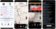
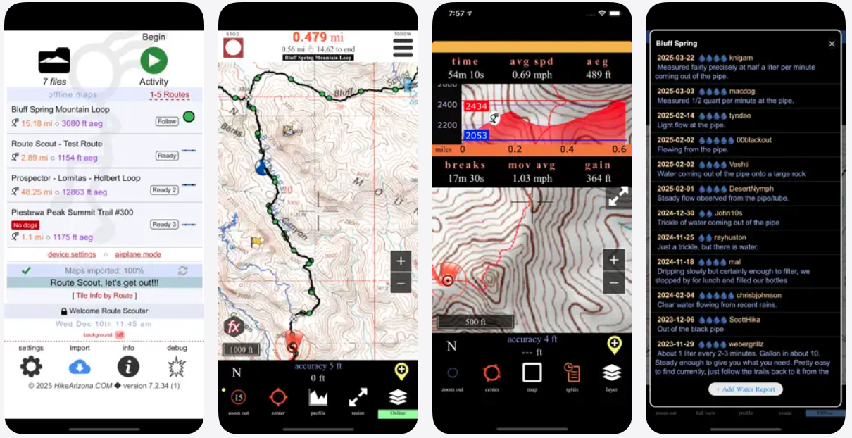
Topographic map, waypoints, mileage, elevation, speed, time, moving average, breaks. Audio options for splits, nearby waypoints, and off-trail alerts.

Direct GPX import. Last imported route auto sets to "Follow". Offline topo maps specific to the route load for navigation.

Optional
Contributing members may import/save from HAZ & Route Cloud™(RC) with Route Editor™(RE) to review, edit, share, post, plan, download & archive. Route Editor™ is an online tool to create, edit & store gps route files ( tracks & waypoints/poi)
ie: gpx, gdb, kml, tcx, fit, etc...
The device will use what it decides as the lowest battery option. When not in airplane mode, the device says "Hey, we already have the cell radio on, let's use that for location instead of powering the cell radio and the GPS radio". The cellular radio gets its location via cell tower triangulation. They estimate your location, by taking the tower that the phone is connected to (not necessarily the closest one) and drawing a circle around the tower. Then it draws a circle around another cell tower and calculates your location. Garbage data builds up as it switches towers.

This is most notable on Android, iOS honors the app's high-precision requests better out of airplane mode.

Not feasible for social butterflies, just explaining.

Dedicated GPS receivers will perform best because they only use satellites. Corporate-driven apps with big pockets from sharing user data might perform better. RS offers the option to edit the recorded route via Save/Share. RS does not auto-set settings, auto-take your data, or share your info with third parties:

RS performs best in the boonies. Folks can not get a permanent cell signal so they buy into turning on airplane mode. Airplane mode will save lots of power because the phone is a phone. It desperately wants to fulfill its intended purpose of finding cell reception unless you explicitly tell it not to by turning on airplane mode. On the same token, not turning on airplane mode near urban areas results in the potential for micro garbage data.
Ignore unless specifically directed here by the admin.

Beta-testing new RS releases
Versioning
0.0.0(0) Major.Minor.Patch(Build)
7.2.8 Build 1 Example
7.2.8(1)
Spot check AEG (Accumulated Elevation Gain) while recording a hike.
  1. Tap profile icon, bottom center of map
  2. Select "track in progress"
  3. AEG is in the upper-right of the elevation profile
Note: Elevation spikes are typical at the beginning of a hike, and out of airplane mode. RS auto cleans spikes roughly every five minutes during a hike and when "Finish" is pressed.
Route Scout AEG
Save/Share &
Optionally Edit Route before posting or up to 5 days after posting

Draft View ( before final post ) & Edit View


Posted View ( only author sees EDIT Route )
How to find the coordinates of an RS waypoint
1) View it on MapDEX
Tap MapDEX
In the upper-right of an RS Triplog, tap MapDEX
or EDIT Route: available to the triplog author for a few days

2) Zoom in on satellite
Zoom in on Satellite
Center the red crosshair over the waypoint
A mouse device hovering over the waypoint switches to a transparent black target for exact centering.

3) Tap Options > D.d for the option to tap/copy the coordinates field highlighted in purple

How to find the coordinates of an RS Note
The +Note option, while recording a route, automatically starts the note with miles-time for the note
ie: x.xx miles - x:xxam
  • Hover over the elevation profile to match up the distance
  • Touch screens - drag finger
  • Tip drag high or low to change the position of the ft-mi popup if obscured
  • Moving across the profile will center the map to the red crosshair on the map
  • If the red crosshair on the profile is a yellow dot, tap to switch to center-to-crosshair
  • Tap Options > D.d for the option to tap/copy the coordinates field highlighted in purple
There are over a dozen topics in Info on RS. Info is at the bottom of the homescreen on RS. If you have a question that is not explained or that you do not understand in RS Info or here on HAZ in RS FAQs, then ask using the Help button at the bottom of this page.
Import Posted GPS Routes on HAZ into RS

List of routes on HAZ profile "Routes" tab or any list of routes on HAZ
- tap the blue download icon in the listing
- tap Send to Route Scout App**

Viewing a route on the HAZ Map
- tap the route on the map desired
- if the left pane info window is closed tap the orange ">" tab on the left of the screen to open

- tap the blue download icon
- tap Send to Route Scout App**
 
** For best results - have Route Scout on the home screen, with the screen on, with strong internet
 
Alternative Import Options

Import by ID
RS > Import > Search or ID > type in ID number of route desired
Look for https://hikearizona.com/map.php?GPS=12356 type of links on HAZ
( 12356 is the ID in the above example )

Download as .gpx then on RS... RS > Import > Select .gpx
If using a laptop or desktop, getting the .gpx file to your phone is a hassle beyond the scope of this helper. Instead download from a browser on your phone that RS is installed.
 
Overview
RS needs the location Always setting allowed to use the GPS radio when the screen is turned off. Important because most people do not hike with their screen on.

Always is Enabled
Recording a hike: Begin Activity to Finish 
Files > file > Preview / Review*
Unsent Water Report
Importing a route, Offline Maps auto import for the route
Files > file > set to Follow

Misconceptions 
Operating system unexpectedly pops up a confirmation that RS has been using battery uninterrupted, or such. Your device periodically reconfirms that you want to allow the location Always setting for RS. The answer is yes/allow ( see above )

Peace of Mind
Swipe RS closed when you are not recording a hike, and you do not see a note on the home screen that a water report needs to send.

* Preview / Review uses your location because this screen is most often used when driving to a trailhead. Tap the circle target icon in the upper left corner to center on your location. When locked onto your location, the icon turns from white to green with a dot in the middle. Whether or not you use this feature, location Always is enabled on this screen. Exit this screen ASAP or adhere to Peace of Mind above

IPhone
  • OFF: A white Navigation icon 
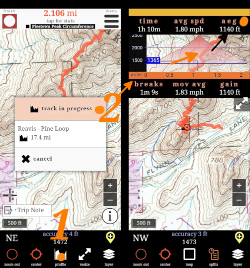
in the upper-left indicates Route Scout is not using Location Always.
  • ON: A blue chevron surrounded by a white circle surrounded by a larger blue oval displays upper-left when RS is initially minimized. This indicates RS is using location Always
  • ON: The blue chevron soon turns to clock/time. It is a quick tap to unlock your phone to RS because location Always is enabled
About
  • Creates an RS Triplog on HAZ: Combines a triplog with a GPS Route
  • After recording a hike on Route Scout: Files > tap the file > Save/Share [ Example ]
  • EDIT Route button atop the triplog before the final triplog "Post" and up to 5 days after

Route in an RS Triplog: Directly view in a triplog:
  • Popup quick, dynamic overview
  • MapDEX advanced planning

On HAZ, where legacy +Add > GPS Route are found:
  • MapDEX Plan > Map > options > Find in View > All - Mine - Follow
  • Mini Map on your profile (triplog tab)
  • Route tab on your profile
  • Guide page: GPS Route & Alternative tabs

Download / Edit
  • Popup > Map Menu > Download GPX
  • MapDEX > tap Send to Route Editor 
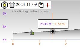
on elevation profile to Send to Route Editor is in
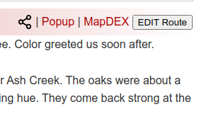
When an RS Triplog is found on MapDEX, the triplog displays without leaving the page.

Private / Public
RS Triplogs have the option to set the route as private.
How to
EDIT Route > tap track on map > tap sync in Track Menu > tap update route
Example screenshot


Should I "sync" the track elevation on RS?
iPhones: rarely needed

Android: it is typically best to sync if the hike is near a metro area and not in Airplane Mode. On Android, the device triangulates with cell towers if it's not in Airplane Mode. Cell tower triangulation is okay for recording location but is often inaccurate in elevation.

Generally, it's apparent when the route needs to be synced. If the elevation profile has a super fine saw blade look that is not data from the GPS radio. Huge elevations variances need to be synced. Huge variances occasionally occur switching in/out of Airplane Mode during the hike. If the profile looks smoother synced, then it's probably best to sync.
iOS settings only need to be set after install or reinstall.
2024 iPhone Settings for RS
Android notoriously turns on power-saving and restricts battery without your knowledge during OS updates. Verify after each OS update or RS might straight-line.
2024 Android Settings for RS
The red links take you directly to the applicable settings.
helpcommentissue

end of page marker