username
X
password
register
for free!
help
ArticlesGuidesRoutes
 
Photosets
 
 Comments
triplogs   photosets   labels comments more
Berry Butte Summit - 2 members in 5 triplogs have rated this an average 3 ( 1 to 5 best )
5 triplogs
login for filter options
Jan 17 2024
avatar

 Routes 5
 Photos 435
 Triplogs 119

female
 Joined Mar 26 2022
 Flagstaff, AZ
Berry Butte loop, AZ 
Berry Butte loop, AZ
 
Hiking avatar Jan 17 2024
shelby147Triplogs 119
Hiking11.50 Miles 4,100 AEG
Hiking11.50 Miles   7 Hrs   53 Mns   1.73 mph
4,100 ft AEG   1 Hour   14 Mns Break
 no routes
1st trip
Linked   linked  
Partners none no partners
I figured I'd better get back into the canyon and hike up something steep to reduce the a**-kicking I'll get with Pernell in a few days. The relatively warm weather was also a motivating factor. My plan was something like, descend Grandview to Tonto then decide what I'm in the mood for.

The trail was quiet and I saw only one other hiker. There is snow to 5000ft and lower on the north-facing slopes but it's not deep yet. I spotted a sheep's behind as it walked over a hill ahead of me. The cottonwoods down in the creek already have leaf buds. The sky was overcast and moody all day and I was glad that the flurries seemed to be concentrated in upper Bright Angel Canyon.

When I reached Cottonwood Creek, I figured I might as well check out the Redwall break in the west arm. The creekbed in the Bright Angel Shale has a rather steep gradient. This Redwall break was very easy from a route-finding perspective but a relative pain to walk up. The ravine has flashed somewhat recently, leaving plenty of boulders that take time to climb over. Eventually I ascended to a sheep trail and contoured, but it was faint and remained poor walking. After a month away from the canyon, I was rather out of breath hiking up here. Near the top of the break where a large bay opens up, I found a much better trail on more moderate slopes.

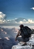
Rather than visit the points toward the river along the Redwall, I decided I'd better keep the elevation I'd gained and continue up and out the east arm of Grapevine. I would like to walk along the Redwall plateaus out to the points between the arms of Cottonwood and between Cottonwood and Grapevine, but that will have to wait for another trip. I had a relatively easy time contouring left around Berry Butte and scrambled up at the standard SW corner because I found no good breaks through the top two Supai bands along my way. On the second to last band I scrambled up by wedging myself in a flake and was irrationally afraid that the huge flake would break. I trust Supai much less, even when it looks solid, since I broke that piece in Grapevine in November. At the corner there seem to be several good ways up the final cliffband, and I opted for a secure and easy way through a small hole, leaving my pack below. There are other neat holes and tunnels in the vicinity. The top of the butte is so flat that I positively trotted up to the summit.

On my way back to Grandview I contoured rather high when I might as well have stayed on a broad flat platform 100ft below. The nice saddle of grey pitted Supai had many wet potholes and (I think) I found a lodgepole pine there, which seems unusual. The walking slowed down as I encountered more boulders and brush below the unnamed Coconino butte. When I neared the head of the ravine, I also had to deal with snow and slidy mud. Here, I was surprised to find a set of snowy bootprints heading down that must have been less than a week old. My guess is they headed into Grapevine, because there were no tracks on Berry and I saw none returning upwards. Ascending the broken Esplanade band and Coconino was challenging because the slopes were so steep that I could hardly move upwards between the slippery snow and deep mud. This Coconino talus seems especially slidy, which makes me feel better about bailing on my first attempt going down here in 2022. There were no more than 3 inches of snow where I rejoined the trail, and I wouldn't want to do this route with much more than that.

All in all, a very satisfying day hike with very little planning.
  1 archive
Aug 03 2019
avatar

 Guides 37
 Routes 556
 Photos 10,872
 Triplogs 1,052

43 male
 Joined Jan 21 2013
 AZ
Horseshoe Mesa 5,246Northwest, AZ
Northwest, AZ
Hiking avatar Aug 03 2019
FOTGTriplogs 1,052
Hiking
Hiking
 no routesno photosets
1st trip
Linked   linked  
Partners none no partners
I can confirm that the Grand Canyon is still hot in August. Not much to say about these summits, just finally ticking off some of the easier Grand Canyon summits off the list.
_____________________
 
Sep 15 2018
avatar

 Triplogs 3

46 male
 Joined Jun 24 2010
 Flagstaff, AZ
Berry Butte SummitNorthwest, AZ
Northwest, AZ
Hiking avatar Sep 15 2018
ElevatedTrailTriplogs 3
Hiking7.00 Miles
Hiking7.00 Miles
 no routesno photosets
1st trip
Linked   none no linked trail guides
Partners none no partners
_____________________
  1 archive
Nov 15 2014
avatar

 Guides 8
 Routes 12
 Photos 1,918
 Triplogs 662

39 female
 Joined Dec 02 2009
 Grand Canyon
Berry Butte SummitNorthwest, AZ
Northwest, AZ
Hiking avatar Nov 15 2014
HippyTriplogs 662
Hiking6.50 Miles
Hiking6.50 Miles   11 Hrs      0.59 mph
 no routes
1st trip
Linked   linked  
Partners none no partners
So this was pure awesomeness!

Jamie Compos suggested this butte and I'm not one to ever turn down some offtrail
So we set off at 8am got dropped off at Grandview by his friend and after a mere ten minute walk down GV we reached our offtrail starting point.

From the top of the coconino we scrambled down a narrow scree filled break in the coco "The Chute" we call it.
It was a long rocky slide but fun!! I love that kind of stuff.

Once into the supai layers we contoured out west and down to the lower of supai layers.
There's a greyish saddle you're aiming for.

Once you hit that saddle we headed out toward the butte! The first supai scramble after the saddle reminded me of the tiny ridge between Cardenas and Escalante buttes.

When we the scramble we followed the sheep path on the north side almost to the end then climb atop.
More supai. Gorgeous boulder field. Another climb.

When we finally reached the butte we had to head up the south side and find our way up to a narrow ledge and a very Battleship-esque looking up climb.

Its a short 7-9 foot chimney. Jamie had to take his backpack off and have me hand it up to him after the chimney.

Because once up that there's a sweet little squeeze hole to crawl through!

For anyone my size there's also a tiny rabbit hole to come up through in the same spot.

After that we were pretty much home free! A short jaunt took us to the true summit with an amazing register line up!! (See photoset!!)

Summit beer and a walk to the far west to check out grapevine. What a view!!!

We headed back via the Redwall Rim Route from Berry Butte back to Grandview Trail. Very easy rim route with a few drainages to sneak through and many demon agave to watch out for.

We topped out at 7pm. (This hike can EASILY be done in 3-4 hours fyi. We just stopped to explore every side drainage and Possible route to other buttes in the area.
Plus...a full day in the canyon is pure bliss.

Writing up full description this week for your enjoyment ;)
_____________________
Canyon Freak Adventures!
 
Aug 26 2001
avatar

 Guides 59
 Routes 1,100
 Photos 1,191
 Triplogs 1,290

male
 Joined Jan 01 2023
 Arizona
Berry Butte SummitNorthwest, AZ
Northwest, AZ
Hiking avatar Aug 26 2001
pseudalpineTriplogs 1,290
Hiking5.16 Miles 2,180 AEG
Hiking5.16 Miles
2,180 ft AEG
 no routesno photosets
1st trip
Linked   linked  
Partners none no partners
  2 archives
average hiking speed 1.16 mph

WARNING! Hiking and outdoor related sports can be dangerous. Be responsible and prepare for the trip. Study the area you are entering and plan accordingly. Dress for the current and unexpected weather changes. Take plenty of water. Never go alone. Make an itinerary with your plan(s), route(s), destination(s) and expected return time. Give your itinerary to trusted family and/or friends.

helpcommentissue

end of page marker