username
X
password
register
for free!
help
ArticlesGuidesRoutes
 
Photosets
 
 Comments
triplogs   photosets   labels comments more
Sacred Mountain - 4 members in 11 triplogs have rated this an average 2.8 ( 1 to 5 best )
11 triplogs
login for filter options
Jan 04 2025
avatar

 Guides 25
 Routes 376
 Photos 5,897
 Triplogs 346

40 male
 Joined Mar 01 2018
 Chandler, AZ
Sacred MountainCamp Verde, AZ
Camp Verde, AZ
Hiking avatar Jan 04 2025
John10sTriplogs 346
Hiking1.57 Miles 289 AEG
Hiking1.57 Miles   1 Hour   7 Mns   1.85 mph
289 ft AEG      16 Mns Break
 
1st trip
Linked   none no linked trail guides
Partners partners
TboneKathy
Route Scout Route Recorded  on Route Scout | Pop | Map | Popup | MapDEX
After visiting the Crane Petroglyph site, we made the short drive to Sacred Mountain and parked just off FR 618, where a group of five hikers were just finishing up and leaving, then we had the area to ourselves. The N/NE side of the mountain is very steep, but the use trail circles around toward the west side, and it's an easy walk up to the top.

As soon as we hit the saddle on the west side going up, the ground was littered with pot sherds, and that continued all over the top. The ruins cover a large portion of the mountaintop but aren't very impressive--the walls are mostly collapsed (some look like they've been partially restacked) and are overgrown, but views of the surrounding area are nice, and there's a line of sight to the hilltop ruin on 4120 that I visited earlier in the day. We spent a little time exploring up there but didn't find any particularly unique pottery or other artifacts other than what appeared to be part of a metate.
 Named place
 Named place [ checklist ]
[ checklist ]  Rancho Roco Roja  Sacred Mountain
 
Dec 17 2024
avatar

 Routes 85
 Photos 3,718
 Triplogs 486

female
 Joined Oct 15 2002
 Rimrock, Arizona
Sacred MountainCamp Verde, AZ
Camp Verde, AZ
Hiking avatar Dec 17 2024
cactuscatTriplogs 486
Hiking1.50 Miles 349 AEG
Hiking1.50 Miles   3 Hrs   16 Mns   1.34 mph
349 ft AEG   2 Hrs   9 Mns Break
 
1st trip
Linked   none no linked trail guides
Partners none no partners
Route Scout Route Recorded  on Route Scout | Pop | Map | Popup | MapDEX
Continuing last week's theme of searching for Sinagua artifacts, I popped on over to Sacred Mountain today.
Another one that was very enjoyable, and which warrants return visits for further exploration.
One gentleman arrived just after I did - he said he always visits when he's in town - but he didn't stay long, then I had the place all to myself.
I didn't find any sort of trail register as was mentioned in previous triplogs. 🤷‍♀️
I enjoyed the tons of pottery - especially the pieces I found myself, versus the ones already gathered and displayed by others. And I finally found my first arrowhead, after all these years of hiking in AZ! A beautiful little bird point with just the very tip broken off.
Everything went right back where I found it, except the arrowhead - which I pushed further down into the dirt to try to hide and protect it ... hopefully it will still be there and I can relocate it on future visits.
_____________________
 
Dec 16 2024
avatar

 Guides 69
 Routes 37
 Photos 3,010
 Triplogs 2,387

55 male
 Joined Oct 24 2010
 Phoenix,Az
Sacred MountainCamp Verde, AZ
Camp Verde, AZ
Hiking avatar Dec 16 2024
mt98dewTriplogs 2,387
Hiking1.57 Miles 170 AEG
Hiking1.57 Miles   1 Hour   30 Mns   1.05 mph
170 ft AEG
 no routes
1st trip
Linked   none no linked trail guides
Partners none no partners
I had actually gone to Camp Verde to rake leaves and felt a little guilty spending the previous day hiking for 9 hours. :lol: So today was a yard day…kind of. I still wanted to get out and visit a new trail. I decided on a short one close to Walker Basin. Sacred Mountain.

Got to the TH off of fs 618 around 2:30. The road going back to the gate has a vehicle restriction, so I had to park off of 618 and hike in from there. There is enough room for 4-5 cars to park in the circular roundabout. When I got there, only one other car was there. The hike in to the gate adds about .5 miles (in and out) to the hike. The trail is pretty obvious. There is only one mountain, more like hill, in the area, and that is your destination. The trail goes along side the fence you passed through and then crosses a dry wash before making its way up the west of the butte. About halfway up there is a saddle with a sign about respecting Indian ruins. The trail description mentions a trail register. There was no evidence of anything like that. It has been 24 years since the initial trail description. Even though some of the things may have changed about the trail, the ruins up top have not. Pretty cool to walk through the remains. Plenty of pottery shards. I would have loved to see what it looked like back in the day. The mesa was bigger than I expected. I could envision 7 or 8 structures up there. Met the other hiker, Trancito(?) and we talked quite awhile about this site and other places we had visited.

On the way back I followed a couple of “use” trails that shot off from the main path. Neither were very interesting or long. Neat, short little hike. No wildlife, though there were a lot of mosquitoes at the top of the butte which were very annoying.
_____________________
 
Jun 08 2014
avatar

 Guides 4
 Routes 205
 Photos 9,282
 Triplogs 526

72 male
 Joined Apr 06 2005
 Phoenix, AZ
Sacred Mtn V-Bar-V & Wingfield Mesa Ruin, AZ 
Sacred Mtn V-Bar-V & Wingfield Mesa Ruin, AZ
 
Hiking avatar Jun 08 2014
HansenazTriplogs 526
Hiking3.00 Miles
Hiking3.00 Miles   3 Hrs      1.00 mph
 no routes
1st trip
Partners none no partners
Decided to get out of the house and go to some "drive-by" sites I was interested in.

Started at Sacred Mountain: bushwacked around a bit hoping to find something unusual at this picked-over place. I did find a few largish sherds at the bottom of the hill but the attraction (such as it is) is the big hilltop ruin. Mainly collapsed - the one impressive wall looked like it might have been re-stacked.

Apparently the residents of Sacred Mountain made the nice petroglyphs at the nearby V-Bar-V site. This is a managed park and visitors are restricted to the main decorated cliff. The docent was quite knowledgeable and I was lucky enough to see the solar calendar in action.

Finally I wanted to find the Wingfield Mesa Ruin which I had read interesting things about (http://verdenews.com/main.asp?SectionID ... leID=46766). The mesa is just a couple miles SE of Camp Verde. Unfortunately there is a Jeep/ATV road that goes to the mesa top and broken beer bottle pieces probably outnumber pottery sherds. Still it's a unique place with ca. 40 attached rooms arranged in a big square - makes an impressive satellite view. The central square is ~50 yds across.

Not a bad way to spend a hot day. Time and distance are estimates.
_____________________
 
Dec 16 2011
avatar

 Photos 106
 Triplogs 88

53 female
 Joined Sep 06 2010
 Tucson, AZ
Sacred MountainCamp Verde, AZ
Camp Verde, AZ
Hiking avatar Dec 16 2011
IHikeTriplogs 88
Hiking1.00 Miles 300 AEG
Hiking1.00 Miles
300 ft AEG
 no routesno photosets
1st trip
Linked   none no linked trail guides
Partners none no partners
_____________________
 
Jun 20 2011
avatar

 Guides 4
 Photos 542
 Triplogs 573

46 male
 Joined Oct 19 2010
 Mesa, AZ
Sacred MountainCamp Verde, AZ
Camp Verde, AZ
Hiking avatar Jun 20 2011
Charger55Triplogs 573
Hiking1.75 Miles 300 AEG
Hiking1.75 Miles   1 Hour   30 Mns   1.17 mph
300 ft AEG
 no routes
1st trip
Linked   none no linked trail guides
Partners none no partners
Many of the hikes on my To Do List are on indefinite hold until the fire danger subsides. So I decided to hit the high country and piece together a bunch of smaller hikes based on ancient Native American culture. The trip went something like this:

Sacred Mountain
Rarick Canyon
V Bar V Heritage Site
Montezuma Well

Camp Verde Cliff Dwellings was also on the list, but with the temperature in the Verde Valley hovering around 95-degrees I opted instead for a long, refreshing dip in Wet Beaver Creek. That was later in the afternoon. My first stop of the morning was Sacred Mountain.

Leaving I house at 445a I arrived at the TH at 710a. Minus the ten minute stop for breakfast I was right on schedule. First thing I noticed was the abundance of cicadas in the open field. They're noisy and they're everywhere. If you get too close they let out a high-pitched chirp, almost a squeak. That scared the pants off of me at first! I thought I stepped on a mouse. After a while it became another common sound of nature.

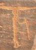
Joe's hike description, written 11 years ago, notes that the trail register is filled with unimpressed visitors. It's still that way today. The entry before mine said something to the effect of "without an archaeology degree I don't get it." I dunno, the only archaeology I know comes from Indiana Jones movies, yet I found this place fascinating. I guess people were expecting something as impressive as Tuzigoot or as picturesque as Montezuma's Castle.

Looking closely on the way up the trail I started to notice pot shards on the rocks. The closer I got to the top the more I saw. When I topped out there was a cairn. Six feet beyond that is a flat rock covered with twenty shards, all of different colors. As a matter of fact, there's so many shards on the ground I was sidestepping around them.

The greatest concentration of ruins is to the east immediately after topping out. There were several collapsed walls outlining the settlement. Unfortunately, there is also evidence of recent diggings. I worked my way along the east ledge and to the best preserved ruin, a rock wall near the north east corner. It's about 3ft high and 12-15ft long. Very impressive! Pottery shards are noticeable in this area as well. The northwest ledge has the remains of several pithouses, some in better shape than others.

While up top I read the part in the hike description about the small lookout on the nearby hill. Interested in checking it out I headed back down and cut off-trail up the hill. I couldn't find evidence of the lookout. However, if you turn around from here you get great views of Sacred Mountain.

Up next: Rarick Canyon
_____________________
"I've driven across deserts, driven by the irony, that only being shackled to the road could ever I be free"
- Frank Turner "The Road"
 
Mar 19 2010
avatar

 Routes 6
 Photos 303
 Triplogs 36

62 male
 Joined Dec 13 2003
 Perth, Scotland
Sacred MountainCamp Verde, AZ
Camp Verde, AZ
Hiking avatar Mar 19 2010
georgesteelTriplogs 36
Hiking1.00 Miles 300 AEG
Hiking1.00 Miles
300 ft AEG
 no routes
1st trip
Linked   none no linked trail guides
Partners none no partners
We found Sacred Mountain interesting with all the ruins and pottery shards. I has brilliant all round views. The GPS that I was carrying went haywire and left a spiked track and said that we hiked at an average of 85 mph and a distance of 50 miles. Maybe the spirits don't like electronics!
_____________________
 
Oct 08 2006
avatar

 Photos 79
 Triplogs 26

female
 Joined Aug 03 2006
 Mesa, AZ
Sacred MountainCamp Verde, AZ
Camp Verde, AZ
Hiking avatar Oct 08 2006
JadeEirTriplogs 26
Hiking1.00 Miles 300 AEG
Hiking1.00 Miles
300 ft AEG
 no routesno photosets
1st trip
Linked   none no linked trail guides
Partners none no partners
Wow! This was a nice, yet very short, hike. It was a great addition to a day on the Bell Trail. Sacred Mountain is strewn with bits and pieces of pottery. The north eastern side was home to former structures of a bunker style as stated in the description. Views surround this ruin from all sides. On this particular day, the wind was blowing like crazy across the top of the incredibly quiet Sacred Mountain.
_____________________
 
Oct 08 2006
avatar

 Photos 1,217
 Triplogs 206

68 male
 Joined Aug 04 2006
 Mesa, AZ
Sacred MountainCamp Verde, AZ
Camp Verde, AZ
Hiking avatar Oct 08 2006
hikemonkTriplogs 206
Hiking1.00 Miles 300 AEG
Hiking1.00 Miles
300 ft AEG
 no routes
1st trip
Linked   none no linked trail guides
Partners none no partners
 Fauna
 Fauna [ checklist ]
[ checklist ]  Tarantula
_____________________
 
May 24 2003
avatar

 Triplogs 5

64 female
 Joined May 22 2003
 Sedona, AZ
Sacred MountainCamp Verde, AZ
Camp Verde, AZ
Hiking avatar May 24 2003
yinofsedonaTriplogs 5
Hiking1.00 Miles 300 AEG
Hiking1.00 Miles      25 Mns   2.40 mph
300 ft AEG
 no routesno photosets
1st trip
Linked   none no linked trail guides
Partners none no partners
I agree, the Sinaguan ruins, the sense of history you feel there, and the 360-degree views atop this white butte are awesome! As are the huge ants! But it was well worth the late afternoon drive from Sedona to hike the short trail and to read the entries in the guest book. History buffs might want to check out a book entitled "Vanished Arizona: Recollections of the Army Life by a New England Woman" by Martha Summerhayes. (Etext is available on the net.) Thanks, Lon, for turning me on to the place AND to the book!
_____________________
 
May 27 2002
avatar

 Triplogs 23

81 male
 Joined Oct 05 2004
 Richmond, IN
Sacred MountainCamp Verde, AZ
Camp Verde, AZ
Hiking avatar May 27 2002
FirekeeperTriplogs 23
Hiking1.00 Miles 300 AEG
Hiking1.00 Miles
300 ft AEG
 no routesno photosets
1st trip
Linked   none no linked trail guides
Partners none no partners
_____________________
 
average hiking speed 1.47 mph

WARNING! Hiking and outdoor related sports can be dangerous. Be responsible and prepare for the trip. Study the area you are entering and plan accordingly. Dress for the current and unexpected weather changes. Take plenty of water. Never go alone. Make an itinerary with your plan(s), route(s), destination(s) and expected return time. Give your itinerary to trusted family and/or friends.

helpcommentissue

end of page marker