|
| | | |
| |
|
| Hiking | 5.59 Miles |
1,087 AEG |
| | Hiking | 5.59 Miles | 4 Hrs 11 Mns | | 1.34 mph |
| 1,087 ft AEG | | | | |
|
|
| |
| Linked |
|
none
[ show ]
| no linked trail guides |
| Partners |
|
[ show ]
| partners | | I planned to hike Preston the Yeti's route up to Apache Leap, along the rim for 2.5 miles to the highpoint, 4875 ft, back track a half mile, down a canyon for .75 miles to a corral, pick up a jeep trail to FR 315, then a couple of miles back to the trailhead. I figured about 8 miles and 2000 AEG. I had posted a date on my Apache Leap wish list. Stoic saw it, sending me a PM, and so I had a partner.
We met up at Buckboard City Cafe for breakfast, getting to the trailhead about 0800. Besides the Magma Mine itself, there was a lot of mining activity along FR 315. Just below the trailhead, it looked like there was an exploratory drill, and mining trucks were driving up and down the FR. (By the time we returned, at 3:30, another drill rig had gone up about a half mile south.) During the course of the hike, we found literally dozens of PVC claim markers.
It's been over six years since Preston laid down his route, so while trying to stick to it, we also needed to find ways around recent growth. It was a steady ascent, but nothing too strenuous. Definitely lots of grab & stabs. (Stoic wore shorts!  ) Between boulder hopping, grab & stab avoidance, and much photography of the awesome rock formations, it took us a couple of hours to get up to the rim. ) Between boulder hopping, grab & stab avoidance, and much photography of the awesome rock formations, it took us a couple of hours to get up to the rim.
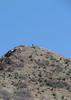
What an awesome view! Superior, Picketpost Mountain, Arnett Canyon, Flatiron, Weavers Needle, Queen Creek Canyon (including both bridges), Pinal Peak and -- I swear -- we could see as far as Camelback.  After at least 30 minutes of rim photos, we started following some cairns just behind the rim. Even with the cairns, it was slow going. We were averaging about 1.0 mph, total time, maybe 1.6 mph walking time. We'd gone 3.5 miles in 3.5 hours. Some quick algebra told me if we did the whole loop, at best we would not be back to the trailhead until 5pm. And all those miles, at least 3.5 to the corral, would be bushwhacking, cairns or not. I didn't want to negotiate that in fading light, so between us we decided to bail down the canyon immediately south of Preston's ascent route. Let us call it After at least 30 minutes of rim photos, we started following some cairns just behind the rim. Even with the cairns, it was slow going. We were averaging about 1.0 mph, total time, maybe 1.6 mph walking time. We'd gone 3.5 miles in 3.5 hours. Some quick algebra told me if we did the whole loop, at best we would not be back to the trailhead until 5pm. And all those miles, at least 3.5 to the corral, would be bushwhacking, cairns or not. I didn't want to negotiate that in fading light, so between us we decided to bail down the canyon immediately south of Preston's ascent route. Let us call it  Canyon, for reasons that will become obvious when photosets are posted. Canyon, for reasons that will become obvious when photosets are posted.
Canyon was much more scrambly and grab & stabby than Preston's ascent. It also had a lot of pools, some a few feet deep, and several areas of audibly heavy bee activity. There were even more claims in Canyon, and even some cairns, which were especially useful as we got further down canyon. We exitted Canyon by the exploratory rig about 3:30 p.m. If we had continued along the ridge, we *might* have just got the highpoint by then, let alone started to work our way back, so, yeah, we chose wisely. 
So, great views, cool rocks, and much stabbiness. 
-----
My wonderful  new Garmin 62S gave me 6.52 miles and 1087 AEG. Stoic's iPhone4 app gave him 5.59 miles and 1000 AEG. I uploaded my track to Route Mgr, and it said only 4.61 miles and 1065 AEG. new Garmin 62S gave me 6.52 miles and 1087 AEG. Stoic's iPhone4 app gave him 5.59 miles and 1000 AEG. I uploaded my track to Route Mgr, and it said only 4.61 miles and 1065 AEG.  My 62S might well be long, but I think Route Mgr is short, so I will compromise and go with Stoic's distance. Either way, it felt like a lot more ... My 62S might well be long, but I think Route Mgr is short, so I will compromise and go with Stoic's distance. Either way, it felt like a lot more ... |
| _____________________
| http://prestonm.com : Everyone's enjoyment of the outdoors is different and should be equally honored. |
| | |
|
|
|
 Route Editor