username
X
password
register
for free!
help
ArticlesGuidesRoutes
 
Photosets
 
 Comments
triplogs   photosets   labels comments more
Longs Peak Summit - 6 members in 12 triplogs have rated this an average 4.5 ( 1 to 5 best )
12 triplogs
login for filter options
Sep 02 2015
avatar

 Guides 2
 Routes 251
 Photos 4,593
 Triplogs 3,212

63 male
 Joined Feb 26 2008
 Scottsdale, AZ
Longs Peak SummitNortheast, CO
Northeast, CO
Hiking avatar Sep 02 2015
BobPTriplogs 3,212
Hiking13.75 Miles 5,387 AEG
Hiking13.75 Miles   8 Hrs   49 Mns   1.84 mph
5,387 ft AEG   1 Hour   21 Mns Break
 
1st trip
Linked   none no linked trail guides
Partners none no partners
My stats were way high.... over 15 miles and 5,700 Aeg. I'm posting stats from the official route.

This one was :y: :y: :y: :y: :y: . Probably will update my top ten favorites soon.

A lot of people turned back at the Keyhole because of the winds. I'm sure Nick will write up an awesome triplog for this one, so I'll end it with this final thought. The coolest thing was this woman rescuing a cliffed out hiker. She not only calmed the guy down, she also soothed all of us down below with her calmness in such a stressful situation :app: . Coolio route
 Culture
 Culture [ checklist ]
[ checklist ]  Benchmark
 Named place
 Named place [ checklist ]
[ checklist ]  Longs Peak  The Keyhole
_____________________
https://www.seeitourway.org
Always pronounce Egeszsegedre properly......
If you like this triplog you must be a friend of BrunoP
 
Sep 02 2015
avatar

 Guides 93
 Routes 397
 Photos 4,984
 Triplogs 4,124

49 male
 Joined Jun 20 2003
 Tucson, AZ
Longs Peak SummitNortheast, CO
Northeast, CO
Hiking avatar Sep 02 2015
fricknaleyTriplogs 4,124
Hiking13.75 Miles 5,387 AEG
Hiking13.75 Miles   8 Hrs   49 Mns   1.84 mph
5,387 ft AEG   1 Hour   21 Mns Break8 LBS Pack
 no routes
1st trip
Linked   none no linked trail guides
Partners partners
BobP
rarely, if ever, have i anticipated a hike so much. i have literally been looking at this mountain and route repeatedly for years. based on weather forecasts, we made last minute switch to go for this one on this given day and it worked out wonderfully.

started in the dark with frigid gale force winds howling down from granite pass. bobby had his rockets on and skyrocketed out of the parking lot. the sun rose along the shoulders of mt. lady washington and the winds seemed to calm a little? treated to a magnificent morning view of the rockies at granite pass. bob was waiting for me at the base of the boulder field and we picked our way to the keyhole wondering what the raging wind had in store for us as it blasted through the keyhole. we encountered a number of people that had turned back because of it. once at the shelter we took a minute to rearrange stuff and bob went out to "check it out"...which made me pumpkin because i knew that meant, wind be damned, it was showtime. i climbed up to the keyhole and looked at bob. he gave me the 'ol come hither gesture, and i thought "holy smokes i'm finally gonna do this...i hate you bob" and off i went onto the scary Ledges and beyond.

bob was essential for me throughout these parts and kept me focused and calm. the Ledges were initially scary then awesome, the Trough kicked our pumpkins, the Narrows were awesome and occasionally creepy and the Homestretch was bleeping steep (and scary on the way down :o ). the summit was totally fantastic.

we had a great trip down, highlighted by some incredibly cool and calm lady basically saving a dude who had got crazily off course and cliffed out on the Ledges. the rest of the trip down was pleasant and the weather was fabulous.

this one goes immediately into my hall of fame. just :pk: awesome!!
_____________________
hi
  4 archives
Aug 21 2015
avatar

 Guides 13
 Routes 38
 Photos 1,651
 Triplogs 577

60 male
 Joined Nov 15 2005
 Jackson, CA
Longs Peak SummitNortheast, CO
Northeast, CO
Hiking avatar Aug 21 2015
toddakTriplogs 577
Hiking15.00 Miles 5,000 AEG
Hiking15.00 Miles   10 Hrs   30 Mns   1.43 mph
5,000 ft AEG
 no routes
1st trip
Linked   none no linked trail guides
Partners partners
t282828
This is the year I hit the big five-oh, and when my son offered to do "something big" with me to mark the milestone, Longs seemed like it would be a worthy goal and a good challenge. With a 330AM start to minimize the chance of getting caught in afternoon thunderstorms we cruised it under sunny skies, with strong gusting winds above the Keyhole and just a few small patches of easily avoided ice. Good to know that 50 is just a number.
 Named place
 Named place [ checklist ]
[ checklist ]  Longs Peak
_____________________
 
Aug 27 2013
avatar

 Routes 17
 Photos 485
 Triplogs 510

77 male
 Joined Jan 07 2010
 Chandler, AZ
Peacock Pool Chasm Lake & Eugenia Mine, CO 
Peacock Pool Chasm Lake & Eugenia Mine, CO
 
Hiking avatar Aug 27 2013
Mike_FelsTriplogs 510
Hiking11.55 Miles 2,880 AEG
Hiking11.55 Miles
2,880 ft AEG
 no routes
1st trip
Partners none no partners
Day 7
Trailhead elevation = 9,300‘ Destination elevation = 11,825’
My last day of hiking up here. Had a couple recommendations for the Chasm Lake hike, so that made it an easy choice. After breakfast at Mickey D’s I was on the trailhead at sunrise. This hike uses the same trail for the first 3.5 miles as the Longs Peak hike/climb. In those 3.5 miles 2,200’ elevation were gained. On a lot of the trails to stop erosion the park service has created steps from either logs 6 to 8 inches in diameter, or rectangular rocks with 4 to 20 inches sticking above the ground. On this hike there were literally a thousand or more step-ups with a median height being about a foot. Very exhausting going up and coming down with those.

Pretty typical start of the trail, in the forest then breaking out above the tree line. A nice stream in the lower elevations. The first stop at 11,500 was a good view of Peacock Pool. So named because of all the colors seen in the waters. Then a beautiful waterfall followed and a bit of a climb up and over a rocky wall.

The lake was fantastic. When I first got there was a unique time. It was one of few times when there was really no wind. Making the lake look like a mirror. It was reflecting the most magnificent cliffs and walls. Some walls were thousands of feet high straight up from the lake. Longs Peak had a good 2,000’ cliff then a steep scree pile ending at the lake.

Within half an hour after my arrival a breeze started up obscuring the reflection.

All in all this was my favorite destination for the seven days.

There were half a dozen elk eating the plants at the ranger station at the trailhead when the hike started. Pikas and chipmunks were running all over the area above tree line.

At the bottom of the trail there was a side trail that led to the Eugenia Mine site. A gold mine that was operated by the Eugenia family in the early 1900’s. Records show that the tunnel had reached 1500’ into the mountain by 1910. There was no record of any gold actually extracted. The park service blasted the entrance several years ago so all that’s left is the ruins of a cabin, a steam boiler and the tailings pile. There are also rotted posts in the nearby stream that used to hold a sluice.

By the time I headed for the trailhead it had started to rain, lightning and thunder. A notable end to a good week.

The Rocky Mountain National Park has over 355 miles of trails. If you don’t mind a lot of elevation gain I heartily recommend hiking there. The scenery, views, wildlife, streams, and waterfalls are some of the best I have ever found. The mornings are usually clear with the afternoons clouding and possibly raining. So early morning hikes are best.
 Flora
 Flora [ checklist ]
[ checklist ]  Whitish Gentian
 Culture
 Culture [ checklist ]
[ checklist ]  Mining Equipment
 Named place
 Named place [ checklist ]
[ checklist ]  Chasm Lake  Longs Peak  Peacock Pool
_____________________
  1 archive
Jul 16 2013
avatar

 Guides 36
 Routes 310
 Photos 2,235
 Triplogs 241

79 male
 Joined Mar 27 2008
 tucson, az
Longs Peak SummitNortheast, CO
Northeast, CO
Hiking avatar Jul 16 2013
rvcarterTriplogs 241
Hiking13.75 Miles 5,387 AEG
Hiking13.75 Miles
5,387 ft AEG
 
1st trip
Linked   none no linked trail guides
Partners none no partners
The gps route I posted a couple of days ago is for a loop up the Loft (past Clark's Arrow) and down the Keyhole. Heck of a hike. We started at 4 am with head lamps and ended at 4 pm. Six of us made the loop on a "bluebird" day, but the loop has numerous places where serious scrambling is a must, up and down. Watch the wet patches. The Loft route intersects the Keyhole route along the bottom of the "Home Stretch" and skirts a small area of snow near the intersection, before going to the summit.

There is additional great information and a waypoint for Clark's Arrow at http://www.denverdavis.com/hikes/hikes. ... longs-loft. The pics I am also posting show the arrow, but denverdeavis has a great shot showing an exploding view from across the way on the Keyhole route.

This is a serious hike for serious hikers. Thanks to Mike for setting it up.
 Fauna
 Fauna [ checklist ]
[ checklist ]  Snowshoe Hare
 Meteorology
 Meteorology [ checklist ]
[ checklist ]  Sunrise
_____________________
Check out my Instagram posts at "cartershift", and videos on my Rumble channel "rvcarter".
 
Aug 03 2012
avatar

 Routes 37
 Photos 2,160
 Triplogs 627

43 female
 Joined Mar 01 2010
 Phoenix, AZ
Longs Peak SummitNortheast, CO
Northeast, CO
Hiking avatar Aug 03 2012
juliachaosTriplogs 627
Hiking13.50 Miles 4,100 AEG
Hiking13.50 Miles
4,100 ft AEG
 no routesno photosets
Linked   none no linked trail guides
Partners none no partners
Ben and Andrea made it to the area, so we decided to attempt Longs. The forecast called for clear skies all day, and winds up to 10-16mph. Unfortunately, long before we got to the Keyhole, the wind was swiftly blowing anywhere from about 30-45mph (estimated higher by others). A good number of people were turning back at the Keyhole itself, with some adventuring through the Ledges and up the Trough, but most turned back once reaching the Narrows. The winds on that side were reportedly much worse, and with very little room to err in that section, to move further seemed like a death wish. We did talk to a few people who had gone all the way to the summit, and most of them were glad they'd survived the winds. One man did say he didn't think the wind was that bad, however. All I know is that it was far beyond anything I'd have liked to have been competing against while hiking the Narrows or the Homestretch.

We took a break at the Keyhole for a while, and then started back. The wind seemed a bit nicer at this point, but with it getting so late in the day and weather being so unpredictable, we continued down the mountain until the Chasm Lake turnoff. We hung out there for a bit and had some lunch, then hiked to the lake. It was beautiful! The lake sits somewhat beneath the Diamond, so we sat and searched for climbers on the wall. We could hear the echoes of voices shouting out commands and other communications, but couldn't locate any moving climbers for sure.

It then started to sleet and rain a bit. I was really glad not to be up on any sort of wall or smooth slabby surface at that point. We headed down the trail and got back to the trailhead early afternoon-ish. A ranger thanked us for not continuing farther on the trail during the adverse weather conditions. Everyone turned out safe that day, including one girl who had suffered altitude sickness, but it only takes one mistake to change that.

We went back to camp for naps, and woke up surrounded by cows. Tore down camp at that point and headed into Boulder for some well-deserved foods.
_____________________
 
Jul 10 2012
avatar

 Routes 37
 Photos 2,160
 Triplogs 627

43 female
 Joined Mar 01 2010
 Phoenix, AZ
Longs Peak SummitNortheast, CO
Northeast, CO
Hiking avatar Jul 10 2012
juliachaosTriplogs 627
Hiking14.00 Miles 5,100 AEG
Hiking14.00 Miles
5,100 ft AEG
 no routesno photosets
Linked   none no linked trail guides
Partners partners
Hikergirl81
We'd actually attempted this a couple days prior, but when we pulled up to the TH, we'd been tired, cranky, achy, sick, and just generally not in the mood. So we'd decided to spend the day in Estes instead, walking around and trying on various hats in various stores, and eating foods with my family, and having just a general good time.

So this time, we parked the Subi on a nice, bumpy dirt road and "car camped" inside so that we could wake up early and get 'er done.

Our early start turned into a late 5am start, but we barreled up the trail and found ourselves at the keyhole. After the keyhole, things got a bit more interesting. We used our hands almost constantly, occasionally had to climb, and then squished ourselves against the walls of the Narrows before scurrying up the cracks along the Homestretch... all this while we watched the clouds slowly accumulate and rise to meet us.

We didn't stay long at the summit, but Janelle did take a few pictures here and there of the whole trip. Had to take a couple days off after this one, as the knee pain (IT band?) has started to return again. Soooo, back to building up that CO brewery list!
_____________________
 
Sep 07 2010
avatar

 Guides 253
 Photos 6,930
 Triplogs 2,467

75 male
 Joined Nov 05 2008
 Cloudcroft, NM
Longs Peak SummitNortheast, CO
Northeast, CO
Hiking avatar Sep 07 2010
imikeTriplogs 2,467
Hiking4.00 Miles 1,500 AEG
Hiking4.00 Miles
1,500 ft AEG
 no routes
1st trip
Linked   none no linked trail guides
Partners partners
cheetah262
still nursing a glitched knee, but enjoying the area...
_____________________
Ageless Mind... Timeless Body... No Way! Use It and Lose It. Just the way it is...
 
Jul 14 2010
avatar

 Photos 1,529
 Triplogs 112

44 female
 Joined Mar 03 2009
 Flagstaff, AZ
Longs Peak SummitNortheast, CO
Northeast, CO
Hiking avatar Jul 14 2010
Hikergirl81Triplogs 112
Hiking14.00 Miles 5,580 AEG
Hiking14.00 Miles
5,580 ft AEG
 no routes
1st trip
Linked   none no linked trail guides
Partners none no partners
I have hiked this once before, last summer. In my opinion, this 14er is fairly epic for a "trail hike." I love the tundra, the base-camp at the boulder field, the keyhole which marks where the hike becomes a challenging scramble, the hellish chute, and the final accent to the top!
We got a later start, we were at the trail head by 7am; ideally sunrise is the best time to start this hike. We made incredible time, I got to lead and set the pace this time. We met the famous old climber Fred Becky except he had taken a serious fall of his horse on the way up, he was going to free climb the diamond face. We passed a few people that said oh no you cannot make it to the top today, its far too late. We continued on and made it to the top, just as the weather was moving in. We took my traditional summit pictures and realized it was time to MOVE! The hail hit, the summit scramble was so slippery when it was wet, it made the trip down SO treacherous. We traversed the inner basin in the hail, it wasn't difficult but the fall from a slip could have been deadly. It was cold and our hands were numb because it was necessary to use then on this scramble, by the time we reached the chute the rain had turned to sleet transforming it into a stream. We skidded our way down the scree waterfalls. The winds were so strong as we passed through the keyhole, then we used the memorial shelter to take off our soaked rain gear. We rested at base came for about 20 minutes but I was ready to go! I lead, literally sprinting down the mountain! There was some trail construction but never any obvious forks in the road. We were making great time... Or so I thought!
Ugh! :oops: I would rather not explain this part but it was another important lesson to learn. We missed a critical fork in the road and (like a previous experience) I was headed down the wrong side of the mountain. I was ready to hit the tree line when Curtis said "This definitely not right!" I was so sore from the day before and going up again seemed impossible! We cut across hoping to intersect the trail, I was so beat I was using a pole and pulling myself up to it for each step! Then on the final up hill stretch Curtis carried my pack (and his)I was so tired dizzy and my legs felt like Jello from the day before. We saw the trail but it was across a huge basin, snow field, and mountain pond...
We caught the trail at battle mountain and noted the time, this detour took us 2.5 hrs but we reached the treeline. We were exhausted but when we passed the waterfalls the lighting was fantastic. I took a few tired pictures and continued on... My feet bottoms were blistered and really hurt but we sprinted down the trail towards the car! Yay!
Of course I wanted to see the trail head map to see what had happened! Ugh, it had happened that we missed the fork at the area where there was trail construction. I am usually observant and I can certainly follow a trail, but I guess this time my lesson was to check the trail map ahead of time to be conscience and cautious of any fork in the road, especially on the way down when you're tired!
_____________________
I don't have a computer… Not because I'm against having one. Really just hasn't been a top priority on my gear list.
I am now attempting to navigate, post, reply (etc..) this site with only an iPhone… Wish me luck!
 
Aug 27 2005
avatar

 Photos 80
 Triplogs 46

45 male
 Joined Jan 27 2011
 Arizona
Longs Peak SummitNortheast, CO
Northeast, CO
Hiking avatar Aug 27 2005
jaboneagarTriplogs 46
Hiking14.00 Miles 5,100 AEG
Hiking14.00 Miles   13 Hrs      1.08 mph
5,100 ft AEG
 no routesno photosets
1st trip
Linked   none no linked trail guides
Partners none no partners
My first 14'r and the most memorable. Night climbed with headlamp and made summit by sunrise. Totally spectacular.
_____________________
Jabon Eagar
Photographer/ Explorer
http://www.jaboneagar.com
http://www.facebook.com/pages/Jabon-Eag ... 270?ref=hl
 
Jul 04 2001
avatar

 Guides 59
 Routes 1,100
 Photos 1,191
 Triplogs 1,290

male
 Joined Jan 01 2023
 Arizona
Longs Peak SummitNortheast, CO
Northeast, CO
Hiking avatar Jul 04 2001
pseudalpineTriplogs 1,290
Hiking19.11 Miles 5,563 AEG
Hiking19.11 Miles
5,563 ft AEG
 no routes
1st trip
Partners none no partners
  1 archive
Aug 02 1985
avatar

 Guides 14
 Routes 9
 Photos 1,378
 Triplogs 287

61 male
 Joined Dec 20 2002
 Phoenix, AZ
Longs Peak - RMNP, CO 
Longs Peak - RMNP, CO
 
Backpack avatar Aug 02 1985
BarrettTriplogs 287
Backpack24.50 Miles 6,500 AEG
Backpack24.50 Miles5 Days         
6,500 ft AEG
 no routes
1st trip
Linked   linked  
Partners none no partners
An article in a magazine titled "The Ten Best Walk-ups in the World" was the seed. I had never taken a plane flight by myself, nor had I climbed a real mountain yet. I was almost 20 and it was time.
Longs Peak, the only Fourteener in Rocky Mountain National Park, was first officially summited by John Wesley Powell and his surveying crew in 1868, though Native Americans claim to have used it's 14,259' peak to gather Ceremonial Eagle Feathers for generations. It's Keyhole Route is considered a Class 3 scramble, but narrow ledges and serious exposure claim an average of 2 lives a year - something I neglected to tell my parents at the airport.
I arrived in Denver, taking a bus to Estes Park, where I wandered around a bit, poking my head in the Stanley Hotel, the inspiration for the fictional Overlook Hotel in Stephen King's The Shining. Very cool.
I returned to the bus stop, thinking I could take a bus further into the park, which I found I could not. Fortunately, one of the drivers assured me it was safe to hitch hike, which I did (sorry Mom). An older couple took me to the campground near the Glacier Gorge Trailhead and wished me luck. I set up my tiny single-wall Boy Scout tent in the dark and tried to sleep, but the excitement of the day and what tomorrow would bring kept me up all night.
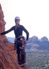
At dawn I took the shuttle to the trailhead and set off, amazed at the size of the mountains all around me. The weather was cool and the skies were clear and I soon reached Alberta Falls, a torrent of white crashing down from boulder to boulder. Soon after I came to a split in the trail that didn't seem to fit. I must have looked confused, because a beautiful girl in a black Steelers T-shirt cut off about 10 inches above her navel with amazing muscular legs asked me if I was lost and we ended up talking for a while. She had once done Longs Peak before going to work, and knew the area like the back of her hand. She pointed me in the right direction and we parted ways, leaving me totally Lovestruck. :GB:
In a daze, I wandered higher on the trail, making it about 4 miles before taking a break as the daily afternoon thunderstorm rolled in. I was just below tree line, and huddled under a downed pine in my poncho until it passed. I made it another 2 miles before the thin air started taking it's toll. Then 1 mile. Then about one half. At mile 8 or 9 I could see the boulder field where I would camp at 13,000', but could only walk about 50 yards at a time before putting my hands on my knees and sucking wind. It was dark when I arrived and set up camp, boiling water with my clunky Optimus 8R and eating dinner - noticing the other mountaineering tents with my flashlight. I crawled into my tent and was out like a light. :zzz:
Until the winds arrived for real. My 2 pole didn't stand a chance, collapsing with little resistance. I gathered rocks to anchor the stakes, but that only lasted for a while, and once again my tent collapsed and pounded me with each flap. ](*,) After a third attempt, I gave up, putting tissue in my ears and curling up in the thrashing orange nylon until the wind finally subsided in the morning. I emerged exhausted, but after clearing my eyes the morning sun illuminated where I was and the adrenaline started to flow. The views were huge, above and below, I already felt like I was on top of the world.
I ate breakfast and made my way across the boulder field following the "Eggs" (a red dot of paint inside a larger yellow dot that act as trail markers) to the Keyhole, a dramatic rock flake that is the namesake of the route. Passing through, I then made my way up the Trough, a 600 foot couloir, followed by the Narrows, where things got wild. The trail clung to the edge of sheer rock, with a lethal fall one false step away. I watched a few others first, and saw how they did it, taking my time but still breathing hard. Finally I reached the Homestretch, steep but not quite as deadly, and I was on top! I had read you see an area the size of Ohio from the top, and I believed it, what a view!
I knew it was important to get down as quickly as possible before the afternoon storms, so I took a few pictures and made my way back, flying down the Trough in no time. I was at the Keyhole well before the storm, so I decided to bop over to the Chasm Lake Overlook, where I had an amazing view of the Diamond, Longs Peak's 900' vertical rock face. The clouds moved in and I found a huge boulder for shelter, huddling underneath as rain, hail and thunder crashed all around. I was loving every minute. :D
When it was clear I returned to camp, where I improved the circular rock windbreak and piled about 200 pounds of rocks on my tent guy lines. I ate dinner and was out cold. Somehow my tent survived the night's gale, and I actually slept through most of it as well.
In the morning I decided to try the old Cables Route, which looked reasonable from where I stood. The European-style cables had been removed due to lightning hazard years ago, but the anchor points remained, and I had heard it could be free-climbed. Higher and higher I climbed, youthful ignorance blinding me to the ever increasing danger. I was climbing at the edge of my ability, thinking that just because the slope was not completely vertical I was O.K. I had done so little climbing I wasn't even aware of how much harder it would be to down climb if I needed to back down. Dumb.
Fortunately, the slope eased and I scrambled to the summit once again, returning wisely via the Keyhole Route and crashing at camp for the rest of the afternoon and evening, enjoying the Marmots, who seemed oblivious to humans.
Once again my tent survived the night and I packed up camp in the morning. The hike down was a breeze, and I spent the night below tree line, where I shared a campfire with a rather friendly group from Denver. We finished the last of the freeze-dried, and then passed around a sticky dessert. The sunset bathed the mountains above us in a golden glow as we recounted our adventures, the flames sending sparks in a swirling dance into the deepening blue above.
 Culture
 Culture [ checklist ]
[ checklist ]  Vintage Hikers
_____________________
The past, the present, and the future walked into a bar.
It was tense.
 
average hiking speed 1.55 mph

WARNING! Hiking and outdoor related sports can be dangerous. Be responsible and prepare for the trip. Study the area you are entering and plan accordingly. Dress for the current and unexpected weather changes. Take plenty of water. Never go alone. Make an itinerary with your plan(s), route(s), destination(s) and expected return time. Give your itinerary to trusted family and/or friends.

helpcommentissue

end of page marker