username
X
password
register
for free!
help
ArticlesGuidesRoutes
 
Photosets
 
 Comments
triplogs   photosets   labels comments more
Wire Pass to Buckskin Gulch - 9 members in 36 triplogs have rated this an average 4.7 ( 1 to 5 best )
1, 2  Next
36 triplogs
login for filter options
Feb 16 2025
avatar

 Guides 3
 Routes 632
 Photos 8,235
 Triplogs 604

54 male
 Joined Apr 13 2011
 Gilbert, AZ
Buckskin Gulch TH to Wire PassSouthwest, UT
Southwest, UT
Hiking avatar Feb 16 2025
ddgrunningTriplogs 604
Hiking6.39 Miles 908 AEG
Hiking6.39 Miles   2 Hrs   38 Mns   2.46 mph
908 ft AEG      2 Mns Break
 
1st trip
Linked   linked  
Partners none no partners
Route Scout Route Recorded  on Route Scout | Pop | Map | Popup | MapDEX
V-Day Trip -- Part 4

After White Pocket, we decided to head up House Rock Valley Road to Wire Pass. Several years ago, we backpacked Wire Pass to Lee's Ferry, and were excited to return.

In the interim, instagram-ification has been strong. Lots of folks on the trail--and a ton of dogs! (The day permits are per person and per dog). Seemed like one in three groups had to have a dog.

A large ladder has been installed at the chockstone shortly after the slot begins, which is no longer a barrier.

At the junction with Buckskin Gulch, we decided to explore up Buckskin since we were unable to head up that direction on our backpacking trip.

At this point, the moisture that dropped the prior couple of days turned to our advantage. Only about 100 yards from the confluence was a mandatory get-your-feet-wet pool. None of the casual hikers were up for that, so once we crossed that pool, we were alone.

Ended up crossing 15+ pools, the deepest of which was mid thigh.

We followed the Gulch up until the slot opened up into a wash, and then backtracked to the start.

An amazing area. The road was pretty good with the exception of a couple of muddy spots south of Wire Pass that would give sedans a struggle, but several sedans on the road north of Wire Pass.
_____________________
 
May 16 2024
avatar

 Guides 16
 Routes 81
 Photos 1,269
 Triplogs 1,144

51 male
 Joined Apr 30 2008
 Tucson, AZ
Wire Pass to Buckskin GulchSouthwest, UT
Southwest, UT
Hiking avatar May 16 2024
azdesertfatherTriplogs 1,144
Hiking8.20 Miles 250 AEG
Hiking8.20 Miles   5 Hrs   43 Mns   1.59 mph
250 ft AEG      33 Mns Break16 LBS Pack
 no routesno photosets
1st trip
Linked   none no linked trail guides
Partners none no partners
Hiked downstream to Arizona and back.
_____________________
"I went to the woods because I wished to live deliberately, to front only the essential facts of life, and see if I could not learn what it had to teach, and not, when I came to die, discover that I had not lived." — Henry David Thoreau
 
Mar 23 2024
avatar

 Routes 386
 Photos 49
 Triplogs 792

43 female
 Joined Jun 23 2015
 Phoenix, AZ
Wire Pass to Buckskin GulchSouthwest, UT
Southwest, UT
Hiking avatar Mar 23 2024
emilystardustTriplogs 792
Hiking9.00 Miles 400 AEG
Hiking9.00 Miles   4 Hrs   33 Mns   2.23 mph
400 ft AEG      31 Mns Break
 no routesno photosets
Linked   none no linked trail guides
Partners none no partners
_____________________
 
Oct 07 2023
avatar

 Guides 12
 Routes 192
 Photos 863
 Triplogs 356

42 male
 Joined Nov 30 2015
 Phoenix, AZ
Wire Pass to Buckskin GulchSouthwest, UT
Southwest, UT
Hiking avatar Oct 07 2023
ShatteredArmTriplogs 356
Hiking6.00 Miles 300 AEG
Hiking6.00 Miles   2 Hrs   52 Mns   2.22 mph
300 ft AEG      10 Mns Break
 no routesno photosets
1st trip
Partners none no partners
My dad wanted to see Buckskin Gulch, and I happily went along. 6-7 years ago I did a shuttle from Buckskin TH to White House, but Wire Pass was new. Wash for the first 1.5 miles, then slot canyon. Didn't see a whole lot of people until we got to the downclimb - guess there used to be a ladder here, but now it's just a rope. Could probably be downclimbed without the rope without too much trouble.

Went probably about a mile down Buckskin, but it's really hard to tell in a slot canyon.

On the way back up Wire Pass, we started encountering the hordes of people. Never a bad time in a place like that...
_____________________
 
Oct 11 2021
avatar

 Photos 5
 Triplogs 1,041

36 female
 Joined Oct 04 2012
 Phoenix, AZ
Wire Pass to Buckskin GulchSouthwest, UT
Southwest, UT
Hiking avatar Oct 11 2021
WaitingForRainTriplogs 1,041
Hiking6.00 Miles 183 AEG
Hiking6.00 Miles   3 Hrs      2.00 mph
183 ft AEG
 no routesno photosets
1st trip
Linked   none no linked trail guides
Partners none no partners
_____________________
 
Apr 24 2021
avatar

 Routes 175
 Photos 2,335
 Triplogs 191

44 female
 Joined Jan 21 2019
 Pine, AZ
Wire Pass to Buckskin GulchSouthwest, UT
Southwest, UT
Hiking avatar Apr 24 2021
jillyonanadventureTriplogs 191
Hiking8.86 Miles 397 AEG
Hiking8.86 Miles   5 Hrs   3 Mns   3.41 mph
397 ft AEG   2 Hrs   27 Mns Break
 
1st trip
Linked   none no linked trail guides
Partners partners
jharvey33
Route Scout Route Recorded  on Route Scout | Pop | Map | Popup | MapDEX
Drove up from Scottsdale Friday night and camped at Lone Rock. We caught a beautiful sunrise in the morning and then headed right over to Wire Pass TH with hopes to beat the crowds.

Upon arrival at the TH there were a good amount of vehicles, but to our surprise we were able to stay away from other people for a good portion of the beginning of the hike! James had been prior and he said they have replaced a tree with a ladder at one of the obstacles, thus making it easier for more people to be able to continue further in the canyon. It was beautiful in there, minus a bit of graffiti (mostly towards the beginning).

We chatted with some backpackers for a bit. They had just finished the Arizona Trail and now were WALKING back home to Montana. Wow! And they were using old school maps not GPS; just super cool people to chat with!

We turned around when the canyon got bouldery because we wanted to save some energy for more exploring around. On the way out, it was a nightmare of huge groups of tourists and honestly we couldn’t get out of there fast enough! Beautiful place, really glad I saw it; would probably only return on a weekday though!
_____________________
Restless between adventures...
 
Mar 29 2021
avatar

 Routes 386
 Photos 49
 Triplogs 792

43 female
 Joined Jun 23 2015
 Phoenix, AZ
Wire Pass to Buckskin GulchSouthwest, UT
Southwest, UT
Hiking avatar Mar 29 2021
emilystardustTriplogs 792
Hiking5.00 Miles 183 AEG
Hiking5.00 Miles
183 ft AEG
 no routesno photosets
Linked   none no linked trail guides
Partners none no partners
_____________________
 
Nov 02 2020
avatar

 Guides 4
 Routes 491
 Photos 10,890
 Triplogs 1,257

55 male
 Joined Nov 20 2012
 Phoenix, AZ
Wire Pass to Buckskin GulchSouthwest, UT
Southwest, UT
Hiking avatar Nov 02 2020
BiFrostTriplogs 1,257
Hiking11.35 Miles 350 AEG
Hiking11.35 Miles   5 Hrs   16 Mns   2.40 mph
350 ft AEG      32 Mns Break
 no routes
1st trip
Linked   none no linked trail guides
Partners partners
slowandsteady
After spending the weekend backpacking North Bass Trail in the Grand Canyon we wanted to day hike something awesome and relatively close by. Buckskin Gulch was an obvious choice so after our post North Bass car camp we headed to Wire Pass Trailhead.

Of course, Buckskin is a popular hike so the parking lot was full and we arrived fairly late morning. Originally, I looked into getting an overnight permit but there were no permits left so we decided to do an out and back instead.

From the parking lot the route follows Wire Pass wash downstream about 1.8 miles until it reaches the confluence of Buckskin Gulch. There are some nice narrows in Wire Pass just before Buckskin as a warmup for things to come. Once in Buckskin the narrows are great from the start and never stops. The creek does open up a little at times but it’s really just one continuous slot canyon the entire way. I believe Kathy and I took several hundred pictures in just 4 to 5 miles of Buckskin Gulch.

I set a time for turn around between 130 and 2 which we pretty much stuck to. However, it’s always difficult to turn around when you just want to see what’s around one more corner. Eventually we picked a spot and had lunch before heading back.

After lunch we headed back and of course took a ton more pictures. Even with the full parking lot the number of people was not too bad. We would encounter groups here and there but everyone was spacing nicely so we could all get the pictures we wanted. It was a great hike back and awesome day overall. Definitely need to come back and do this as an overnight. Not to mention the fact the further down canyon will lose most of the day hikers.

After finishing up the hike we headed to Kanab for the night. We still have more hiking to do!!
_____________________
  2 archives
Apr 08 2019
avatar

 Guides 1
 Routes 269
 Photos 613
 Triplogs 1,360

50 male
 Joined Dec 22 2003
 Tucson, AZ
Wire Pass to Buckskin GulchSouthwest, UT
Southwest, UT
Hiking avatar Apr 08 2019
RedwallNHopsTriplogs 1,360
Hiking8.00 Miles 300 AEG
Hiking8.00 Miles
300 ft AEG
 no routesno photosets
1st trip
Linked   none no linked trail guides
Partners none no partners
Recovery hike after a couple of big days doing Water Pockets canyon the previous two days. Took Wire pass in and hiked a waze downstream past the slotty area to get views of the buttes - then hiked up canyon a waze. First time here.
_____________________
 
May 08 2018
avatar

 Guides 7
 Routes 72
 Photos 14,456
 Triplogs 627

62 female
 Joined Aug 19 2011
 Scottsdale, AZ
Wire Pass to Lee's Ferry, UT 
Wire Pass to Lee's Ferry, UT
 
Backpack avatar May 08 2018
outdoor_loverTriplogs 627
Backpack52.40 Miles 750 AEG
Backpack52.40 Miles4 Days         
750 ft AEG
 no routes
1st trip
A Trip that has been on my List for a long Time. I felt like I was finally in good enough shape to do it and was able to score a Permit earlier this Spring to do it now....I had never done anything in this Area before and this was quite the Introduction to an Amazing Group of Canyons... :y:

Having some Wonderful Routes and Waypoints from Previous Hikers including ddgrunning and chumley really helped a lot. I went ahead and used chumley's AEG Stat because somehow, my Track AEG of 13,000 feet of Gain didn't seem quite Right.... :lol: I guess a Point every 100 Feet has you going up to the Top of the Canyons and back down a lot. My Legs thought I'd done that kind of AEG though.... :sweat:

Even as decent as I am and feel, this Trip still took it's toll. I tweaked my Right Ankle really good a couple of weeks before this in a Technical Canyon. I came down Hard, Fast and Awkward on a Rock while Downclimbing and it hurt. I was able to walk it off after about 20 Steps and didn't really give it another thought and it didn't bother me after that. Until Day 3 of this Trip. With 28 Miles behind me, carrying a Heavy Pack, it told me in no small Pangs that it apparently wasn't 100% and I struggled most of that Day with it. I'm now on RICE for a few days with a bit of Swelling.... ](*,) I had to dig deep a few Times to stay close to the others on that Day. By the last and Final Day 4, I think I was just flat out Numb and actually did pretty well... :sweat:

The Weather Semi-Cooperated in that there was no Threat of Rain. Just a Heat Wave... :sweat: I was almost thankful it was warmer, otherwise we might have gotten pretty chilled on the first Day....Day 3 and 4 were pretty hot, but we found ways to cope and it was fine.... Just a few Notes from our Trip by Day.

Day 1: Wire Pass to Buckskin/Paria Confluence
If you are used to Downclimbs, the Chock Stone in Wire Pass is fine, although much easier with Pack Removal. Only a couple of Pools in Buckskin were up to your Chest, most were Knee to Thigh Deep, with a couple of Crotch to Waist Deeps thrown in for good Measure. Lots of Mud still, they had some good Rain the Week before, and there was some Quicksand. The Cesspool is still a Cesspool and the Log Jam in the End kept it interesting in terms of Exiting the Pool. It was Best to force the Logs down under the Water and step on them, instead of pushing through them, they were just too thick and tight. Although the Ranger told us it wasn't, the Rabbit Hole was Open. It was hard to pass a couple of the Packs through it, but we fixed that by lowering them from another spot along the Top using the 25' of Webbing that I had brought with. The Downclimb through the Hole was fine. One Rattlesnake Encounter before the Confluence and he was not a Happy Camper, but ultimately yielded for us to get by...

Day 2: Buckskin/Paria Confluence to just beyond the Judd Hollow Pump
There were 4 of us in the Group. Two of the Photographers had already seen Slide Rock Arch upriver since they had done White House to Confluence before. I had not, so while the others chilled a little longer at Camp, I started a bit earlier, dropped my Pack at the Confluence and Hiked up the Paria to see it. Not really a "True" Arch, more like a Collapsed, Leaning Pillar, but the River flows underneath it and it was pretty cool. I was Amazed at the Mint Green Hue of the Water and Mud of the Paria as well. Met the others back at the Confluence and continued Downstream. I added the Springs and Seeps to the Water Report Data Base and have Attached Reports to this Log as well. The Walls of the Paria Canyon were just as Amazing as those of Buckskin and it was a Great Day.

Day 3: Judd Hollow Pump Area to Camp 3 between the Last Reliable Spring and Bush Head Canyon
I struggled a lot on this Day. The Legs were Guitar String Tight and the Ankle flared up and became pretty painful even with Advil on board. I was slow and had to take Break every couple of Miles to get the Weight off. We did the Side Trip up to Wrather Arch and it was well worth the Trip. Even before you make the Final Climb to the Arch, the Trail led you through a wonderful Riparian Environment and in one spot, I'm betting the Temp dropped 15 Degrees... It was Sweet. My Legs and Ankle did fine on the Side Trip with the Weight of the Backpack gone for a bit. But the Pain returned once the Pack was back on, as we headed for our next Stop.... We finally made the Last Reliable Spring and we already had a Plan to take a very long Break there and eat Dinner. We stayed in the Shade there for almost 3 Hours, ate Dinner, drank a lot of Water and just Chilled. It was a great Plan and it worked out well. I was able to get off the Ankle for an Extended Period of Time and when we got going again to do the last 2 or so Miles, it was almost 6:00 P.M. and the Temps had cooled significantly. The last Miles were pleasant and almost Pain Free...

Day 4: Camp 3 to Lee's Ferry
I hadn't slept well all Week due to Night Leg Pain and the last Night was no Exception. When I got started, I felt like I hadn't had any Rest at all. We started an Hour earlier to try to beat most of the Heat, as we knew it would be mostly Exposed with little Shade. Another Good Plan on our Part. Somehow, after about 2 Hours of struggling on what really was easy Trail, my Body found a 2nd Wind. Perhaps due to the Doubling of Advil, and an early start downing a 5 Hour Energy Shot. I think those contributed along with my Brain realizing that Pain signals weren't making me stop what I was doing, so it just made everything sorta Numb... :sweat: Maybe a little "Horse Back to the Barn" Mentality as well... All I know, is that the Ankle didn't hurt nearly as bad, and after awhile, the Stiffness and Tightness eased up some and I was able to start Cruising. We took a short Break at Wilson Ranch and then a longer Break in the Shade just before the Cemetery, knowing we were VERY close to the Finish Line. We finished in good Time. Even with the Breaks, we managed 11 Miles in 5.5 Hours... After my Performance the Day before, I was really happy about that. And we were out of the Heat and probably beat the worst Heat of the Day.... :y:

We decided to take a Dip in the Colorado before departing for the Drive back to Wire Pass. Two of our Party had never been to Lee's Ferry before and had no Idea about the River and the Water Temp. We told them it would be Cold, but we didn't elaborate too much... :sl: I knew how cold it would be, but I also knew that it might feel damn good on my Legs and Ankle. I was right and I literally soaked for a while in that River. If I was Numb before, I was totally senseless when I crawled out of that Water.... :sl: We had an Amazing Meal at Strombolis in Page before getting back to our Vehicles at Wire Pass.

We had thought about doing a Paid Shuttle, but there were only 2 of us coming from AZ, the other two were coming from Salt Lake City, so it didn't make Sense for them to drive all the way around to do the Shuttle. So we left one Vehicle at Lee's and I drove us around for the start the next day. I had to pick up the Permit anyway at the Contact Station so it worked just fine and the Utah Couple met us at Wire Pass that Night.

What a Trip... I was long Overdue to do this one and I'm so glad I'm at the Point where Trips like this are Possible because there's just too much good stuff out there that I don't want to miss... And even with some Pain, this one was certainly worth it and I could actually see doing it again sometime... :D

Photos possible at some Point... I'm about a month behind on Photos from Trips, so it may be awhile yet.... I've been playing hard lately. Only been Home 16 Days of the last 45... I'm all about Canyons this Spring... :sweat:

wildflower observationwildflower observationwildflower observationwildflower observationwildflower observation
Wildflowers Observation Light
Spotty Blooms in the Narrows of all the Canyons. Once Paria opened up, the Hedgehogs were Blooming nicely...

water 1 out of 5water less than maxwater less than maxwater less than max Adam's Spring Dripping Dripping

water 1 out of 5water 2 out of 5water 3 out of 5water less than max Big Spring Paria Canyon Gallon per minute Gallon per minute

water 1 out of 5water 2 out of 5water less than maxwater less than max Buckskin Seep Quart per minute Quart per minute
Pools and Flow good enough to Filter from....

water 1 out of 5water less than maxwater less than maxwater less than max Bush Head Canyon Dripping Dripping

dry Coyote Wash Dry Dry

water 1 out of 5water 2 out of 5water less than maxwater less than max Judd Spring Paria River Quart per minute Quart per minute

water 1 out of 5water 2 out of 5water less than maxwater less than max Last Reliable Spring Quart per minute Quart per minute

water 1 out of 5water 2 out of 5water less than maxwater less than max Paria Canyon Light flow Light flow

water 1 out of 5water 2 out of 5water less than maxwater less than max Paria Canyon Light flow Light flow

water 1 out of 5water 2 out of 5water less than maxwater less than max Paria River Light flow Light flow

water 1 out of 5water less than maxwater less than maxwater less than max The Hole Spring Dripping Dripping

water 1 out of 5water less than maxwater less than maxwater less than max Wilson Ranch Paria River Dripping Dripping

water 1 out of 5water 2 out of 5water less than maxwater less than max Wrather Canyon Quart per minute Quart per minute
_____________________
Life is not a journey to the grave with the intention of arriving safely in a pretty & well preserved body, but rather to skid in broadside, totally worn out & proclaiming, "Wow What a Ride!"
 
Nov 10 2017
avatar

 Guides 37
 Routes 556
 Photos 10,872
 Triplogs 1,052

43 male
 Joined Jan 21 2013
 AZ
Wire Pass to Buckskin GulchSouthwest, UT
Southwest, UT
Hiking avatar Nov 10 2017
FOTGTriplogs 1,052
Hiking11.53 Miles 250 AEG
Hiking11.53 Miles   4 Hrs   49 Mns   2.52 mph
250 ft AEG      15 Mns Break
 
1st trip
Linked   linked  
Partners none no partners
Gosh do I wish I could have got on @Chumley and @John9L's backpacking trip last year after hiking a little bit of this one on Friday! This area speaks for itself and really needs no praising or hype. It is truly a special place.

In terms of day hiking, unless going along way, I don't think an early start is absolutely necessary, as you will be in the shade most of the morning. We started around ten and seemed to get some pretty good light at times, in fact, the Iphones rarely saw our pockets on this day. I love the fact that this canyon is dog friendly and we had no problem paying the six bucks admission per pup. Although, we carried our ticket with us not realizing we were suppose to put it on display in car, so even despite paying, we got a written warning, oops! We did not see too many people either, a few tripod carrying photags on the way out, but that was about it. An amazing place and worth the drive. I hope to backpack the entire length to Lee's Ferry in future.
_____________________
 
Oct 02 2017
avatar

 Guides 1
 Routes 226
 Photos 1,675
 Triplogs 1,867

65 male
 Joined Oct 17 2008
 Phoenix, AZ
Wire Pass to Buckskin GulchSouthwest, UT
Southwest, UT
Hiking avatar Oct 02 2017
rcorfmanTriplogs 1,867
Hiking5.05 Miles 278 AEG
Hiking5.05 Miles   2 Hrs   19 Mns   2.18 mph
278 ft AEG10 LBS Pack
 
1st trip
Linked   none no linked trail guides
Partners none no partners
Yesterday my wife and I went to Kanab to play the Wave Lottery. We played but didn't win the ticket to the wave so we headed over to the NM to check out the area anyways. Earlier in the day we drove out to Paw Hole and decided to take the Wire Pass trail to Buckskin Gulch, then hike either up or down stream for a bit, then head back.

Like an idiot, I left my phone in the truck and didn't bring the spare camera battery so my camera died just after we reached the slot canyon portion of the trail. Boo hiss.

A short distance after the wash becomes a slot canyon, there is about a 7' drop. There is an old tree stump/branches to help you out but it is very slippery, along with the rocks. I made it down but my wife didn't want to chance it, so I climbed back up and we turned back out of the slot and took the alternate cairned trail around.

Once we reached Buckskin Gulch, we checked out the petroglyph wall (just a few small glyphs), then headed upstream for about 20 minutes before turning back. We really enjoyed this part. It was a slot canyon and there was some water and mud but it was easy to navigate around. On the way back, my wife slipped and got one foot wet.

Back on the Wire Pass trail, we took the slot up and my wife climbed up the one part so we didn't have to take the alternate on the way back. Just after we exited the slot, my wife took a tumble and bruised herself up and tore her thumbnail to the quick. She's a trooper though and didn't complain but I could tell she was hurting. :(

Except for the mishap, we really enjoyed this hike.

We camped at the State Line campground about a mile south of the Wire Pass trailhead. It's clean and well kept and free. There is no water but there is a covered picnic table and a fire pit at each site, ours was recently raked and swept. There is also clean privies.
_____________________
Go find a LonelyCache
 
Apr 01 2017
avatar

 Guides 3
 Routes 43
 Photos 666
 Triplogs 41

54 male
 Joined Jun 17 2013
 Phoenix, AZ
Buckskin Gulch TH to Wire PassSouthwest, UT
Southwest, UT
Canyoneering avatar Apr 01 2017
cdeperroTriplogs 41
Canyoneering9.93 Miles 875 AEG
Canyoneering9.93 Miles   3 Hrs   47 Mns   2.71 mph
875 ft AEG      7 Mns Break
 
Linked   linked  
Partners none no partners
See my triplog for the previous day, March 31, 2017 for more details. This is the photoset for the following day...April 1, 2017, when we retraced our steps because House Rock Valley road was solid sticky mud from Buckskin Gulch TH to Wire Pass.

I put my 2015 Jeep Cherokee Trailhawk in 4WD and still was fishtailing....because my treads and wheel wells were solid with sticky clay! Plan B then....redo Buckskin Gulch to Wire Pass, and then travel downstream in Buckskin Gulch until we decide to turn around...which was at the first pool of water we got to, about a mile south of the Wire Pass confluence.

It was worth redoing....the day was sunnier, though the wash and the slot way more wet (with water still running) than the day prior.
_____________________
  1 archive
Mar 31 2017
avatar

 Guides 3
 Routes 43
 Photos 666
 Triplogs 41

54 male
 Joined Jun 17 2013
 Phoenix, AZ
Buckskin Gulch TH to Wire PassSouthwest, UT
Southwest, UT
Canyoneering avatar Mar 31 2017
cdeperroTriplogs 41
Canyoneering9.86 Miles 598 AEG
Canyoneering9.86 Miles   3 Hrs   50 Mns   2.65 mph
598 ft AEG      7 Mns Break
 
Linked   linked  
Partners none no partners
This hike was a scouting event for a future group hike. I took a good friend along and we first stopped off at the BLM Paria Contact Station on Route 89, where they told us House Rock Valley road was quite sticky and rutted past the Buckskin Gulch TH (i.e. the rest of the way to the more popular trailhead, Wire Pass). So we decided to go see how bad the condition of road was from 89 to Buckskin Gulch TH. Just after leaving the contact station, we picked up an Australian hitchhiker who we had seen loading his pack at his car near the contact station. Turned out he was going to do the Buckskin-Paria loop back to the contact station, so we had some additional company for a while!

The road was fine to Buckskin Gulch TH--we didn't try past that, so I don't know the condition--this day. Keep reading.

We unloaded and started out as light snow flurries started coming. Well, at least they wouldn't cause a flood, right? We thoroughly enjoyed all of the sandstone formations, the same types as a bit further south in the Coyote Buttes area. There are many trails which "shortcut" the corners of the wash, but you can follow the wash all the way if you want. Some of the sand in the wash wasn't as easy to walk on so we took a few of the shortcuts.

About 3 miles in we got to the beginning of the famous Buckskin Gulch slot canyon. It's pretty cool coming in this way...it's a gradual narrowing, and when the slot is only about 30' deep you get excited because it's starting. Then it gets deeper...and deeper....and darker, and very cool. This area, still upstream of the Wire Pass confluence, is very scenic and far less rocky than the Buckskin Gulch slot downstream from Wire Pass. But I'm getting ahead.

We arrived at the confluence with Wire Pass, which is pretty obvious. We found the trail register, which is near the faint petroglyphs on the south side of the Wire Pass canyon, left of the big arch. We then hiked a bit up Wire Pass to see what it was all about, and yes, it's pretty darn narrow! Very cool.

At this point, our Australian friend (Felix) set off on the rest of his hike while me and my friend returned the way we came...with a bit better weather as the day went on.

The next day was intended to be a hike from Wire Pass into Buckskin, and then further downstream in Buckskin, but that was not to be as the rain happened again overnight and getting to Wire Pass was not possible. House Rock Valley Road was impassable south of Buckskin Gulch TH, even with a Jeep Cherokee in 4WD--too much sticky clay. So we ended up redoing this same hike (on a sunnier day) but in a much wetter canyon, and went a bit below Wire Pass.

This hike is very much worth doing....I know a lot of people want to "get right in the slot" at Wire Pass, but consider this version. You get the slot canyon, but a lot of other gorgeous scenery too.

I also want to thank ddgrunning for his excellent trail report for his Buckskin-Paria hike earlier this month! Was really helpful to read such a recent triplog in planning this hike.
_____________________
  1 archive
Mar 16 2017
avatar

 Photos 75
 Triplogs 10

54 male
 Joined Mar 17 2014
 Tucson, AZ
Wire Pass - Buckskin Gulch - Paria Canyon, UT 
Wire Pass - Buckskin Gulch - Paria Canyon, UT
 
Backpack avatar Mar 16 2017
gunungapiTriplogs 10
Backpack42.00 Miles 314 AEG
Backpack42.00 Miles4 Days         
314 ft AEG
 no routes
1st trip
Partners none no partners
I did this hike with my 14 year old son, along with my friend Sam and his son. We did the hike in an unconventional manner because of a last minute change in plans. Our original plan was to hike from the Whitehouse Trailhead down Paria Canyon to Wrather Arch and back in four days; however, my son woke me up in the middle of the night at Whitehouse Campground the night before we were to start hiking to tell me that he didn’t feel so good, and then proceeded the throw up six times within an hour. Fortunately he felt better the next morning, but nonetheless we decided it would be prudent to day hike from Wire Pass Trailhead into Buckskin Gulch rather than backpack down Paria Canyon with full overnight packs.

So, for our first day we hiked about six miles into Buckskin Gulch and then back out again. Buckskin Gulch is an amazing natural wonder. I had visited Lower Antelope Canyon with my family last fall, and while Lower Antelope has more color, and more finely featured swoops and turns, the crowds and tour guides with cattle prods made for a less than spectacular experience. (I’m just kidding about the cattle prods, but only barely.) Buckskin Gulch, on the other hand, was relatively deserted, and it seemed to go on forever. Whatever it lacked in nuance it made up for in quantity and variety.

At one point during our hike I noticed an interesting feature on the canyon wall about 100 feet up. It looked a bit like an Indian feather head dress, or maybe a small section of white picket fence. It didn’t necessarily look natural, and it didn’t seem to fit with the surrounding cliff walls, but then again it was hard to imagine how or why someone could have put something like that so far up on the cliff wall. More on this below…

After another night at the Whitehouse Campground, we started our second day of hiking by heading down Paria Canyon. Paria Canyon was not nearly as visually stunning as Buckskin Canyon, at least until we reached Slide Rock Arch. However, for my money, Paria Canyon from Slide Rock Arch down to the Confluence was one of the best parts of the trip. The canyon walls are so tall and sheer that I felt like I was walking in a landscape made for giants. Wading through the knee-deep, muddy yellow Paria all the while made it even more memorable.

At the Confluence we turned up Buckskin Gulch, dropped our packs at the campsites just upstream, then headed further back down Paria Canyon in search of the 10-mile spring. I had seen online photos of hikers posing in the uniquely shaped vertical fault lines that occur several places in this stretch, so I asked Sam and the boys to pose for photos too; however, quicksand prevented them from getting within 20 feet of any of the fault lines. There was a fair amount of quicksand over this stretch.

On the way back up canyon from the spring we found a clue to identity of the mysterious structure on the canyon wall we saw in Buckskin Gulch the day before. At one point we found some bee honeycomb on the ground; while we stopped to look at the honeycomb, I happened to glance upward, and I noticed a structure on the cliff wall overhead exactly like the one I had seen the day before in Buckskin Gulch. Therefore, I’m pretty sure it was a bees’ nest. I’ve included photos of this structure and the honeycomb in the photoset for this triplog.

Back at the Confluence campsites, we camped at the site on the south side of the creek. Five parties camped on the other side of the creek. The canyon was so echo-y that we could almost everyone’s conversations as if they were right next to us. It made you want to whisper.

The following day we hiked up Buckskin Gulch to the Middle Route and back. The rabbit hole at the Boulder Jam was open but it required a wade through a pool of unknown depth, so we chose to climb over the Jam using the semi-permanent webbing instead. Not far above the Jam we had to wade through a stretch of thigh-deep water, so we ended up getting a little wet anyway.

I found the lower portion of Buckskin Gulch even more impressive than the upper end. It wasn’t as narrow, but it was definitely deeper. At times the sunlight was almost blocked, and the air was chilly.

The climb up the Middle Route was definitely worth it, just to see the outside world for a few minutes. It was a jarring experience, after having spent 1-1/2 days in the canyon and feeling isolated from the outside world, to climb up the canyon walls a few feet and then to suddenly find oneself back in the Utah desert. The temperature change added to the effect when the pervasive cold of the canyon was suddenly replaced by the desert heat.

The climb was fairly easy, except that all of the climbing surfaces were sloped slightly downward and covered with a fine layer of sand that felt a bit like thousands of tiny ball bearings. Surfaces that otherwise would have been easy to stand on did not feel so safe. I’ve seen online images of a route that goes straight up the crevice, but that seems like the hard way to do it; we had good luck criss-crossing back and forth, at least on the lower portion.

We spent another night at the Confluence, and strangely enough, this night we had the whole area to ourselves. I had been irritated by the crowd the first night there but the second night actually seemed lonely. We found that we could pump water from Buckskin Creek by digging a hole in the sand, lining it with flat rocks, and then waiting for the creek's flow to remove the muddy water from the basin, so we didn’t have to make another trip to the 10-mile spring.

The following morning we had an uneventful hike back to the Whitehouse Trailhead.

Overall we hiked about 42 miles over our four days, essentially hiking the Wire Pass Trailhead to Whitehouse Trailhead route both directions except for a couple of miles in the middle of Buckskin Gulch that we missed altogether, plus tacking on the short trip to the 10-mile spring.

I’ve had enough slot canyon hiking for a while, but Sam and I agreed that we do it again a couple of years, and next time we'll hike from Wire Pass to Lees Ferry, with a short detour from the Confluence up to Slide Rock Arch just to see that stretch of Paria again.

A quick warning about the human waste bags (which we affectionately dubbed “Silver Bullets”) issued by the BLM with overnight permits. While it is true that the BLM will provide you with the bags when you pick up your permit, what they don’t tell you ahead of time is that each person only gets one. If you’re backpacking for more than a day or two and you don’t want to use your silver bullets more than once, you should bring some of your own. (It’s obvious once you get into the canyon why the bags are required – there’s just not enough dig-able real estate in much of the canyon to support lots of cat holes.)
_____________________
 
Mar 11 2017
avatar

 Guides 3
 Routes 632
 Photos 8,235
 Triplogs 604

54 male
 Joined Apr 13 2011
 Gilbert, AZ
Wire Pass - Buckskin Gulch - Paria Canyon, UT 
Wire Pass - Buckskin Gulch - Paria Canyon, UT
 
Backpack avatar Mar 11 2017
ddgrunningTriplogs 604
Backpack50.00 Miles
Backpack50.00 Miles4 Days         
 
1st trip
I have had this trip on my radar screen for several years. When @chumley and @John9L posted detailed triplogs, photos, and route information from their adventure last March (thank you!), I could resist no longer.

So, with my three teenagers (17, 14, and 13) heading into Spring Break, I targeted the permit timeline and put in for a trip down what is touted as the longest slot canyon in the world, and then beyond.

My wife was a little hesitant to sign on, but when I told her: (1) there would be no way to escape a flash flood for miles--making this one of Backpacker Magazine's 10 most dangerous hikes in the U.S.; (2) there would be freezing cold pools of water to wade through (and perhaps-- :o --swim through); (3) there would be quicksand to navigate; and (4) everyone would have to use "wag bags" and carry around their poop for four days--she was ALL IN!! :lol: :y:

Permits:
A couple of notes.
Overnight entry is limited to 20 people per day (no limit on day hiking, which involves a self-pay permit at the TH). You can apply for overnight permit 3 months in advance via the BLM's on line permit system (e.g., permits for March are available on Dec. 1). The glitch we had with the permit system was that they make you pick them up in person. They say this is so that: (a) they can give you your wag bags (which come with the cost of the permit) [a crappy reason--pun intended], and (b) so they can size you up and see if you are really prepared for this kind of adventure [perhaps a better reason, but still a pain in the rear for someone coming from out of Arizona]. Normally, people like me can get around this by picking up the permit on the way to the trailhead at the Paria Contact Station just off of Highway 89. That wasn't an option for us, since the station is closed in the winter months and doesn't open till around March 15.

After a few phone calls and emails with the BLM ranger, including sending him confirmation that we had purchased our own wag bags and sending him a detailed trip itinerary, he agreed to mail me my permit.

Planning:
In addition to the great triplog resources of HAZ, I took @Chumley's advice to search hashtags on social media in an effort to get the most current conditions. This was surprisingly successful, as I was able to get feedback from several folks who had been in the slot in the couple of weeks prior to our trip.

Day 0--Friday March 10: Lee's Ferry Campground
Traveled to Lee's Ferry Campground after the kids got out of their 1/2 day of school. Earlier that morning, I got a call from our shuttle driver, wondering where we were. Confused, I told/reminded him that our shuttle was for tomorrow morning. He had written down the wrong date. Oops! ](*,)

We arrived at the campground in the early evening, set up camp and then went down and enjoyed the moonrise to the sound of the Paria Riffle on the "beach" just down stream from the boat launch. The full moon was scheduled for Sunday, so we were in for some bright evenings in the canyon.

Day 1--Saturday, March 11: Wire Pass to just shy of Buckskin/Paria Confluence (14 mi.)
We awoke early and packed up for the shuttle to Wire Pass TH, where we would start our adventure. We went with Grand Staircase Discovery Tours ($175 for 4 people; an extra $50 for each person beyond that). Our shuttle driver, Jim, was good company on the drive. He indicated that most people had been scared off of starting at Wire Pass, due to the number and depth of the freezing cold pools in Buckskin. He applauded our chutzpah for tackling it anyway. Most recent intelligence on trail conditions was from the BLM Ranger, who emailed me after hiking from Middle Route exit back to Wire Pass TH the Wednesday before our trip:

"There are quite a few pools of very cold water for a few miles before middle route that were waste deep on me and I am about 6'2". The main problem I ran into was the slippery mud surrounding and within these puddles. I highly recommend bringing trekking poles to help keep you balance, and to test water depth. I believe that the longest pool was about 100 ft long but I am not very good at judging distance when I am that cold. The temperature of the canyon was actually pretty pleasant with a light jacket on, just be careful not to slip into the pools. The temperature of the pools was enough to make my legs go numb for a while."

Back to the shuttle: Instead of going around through Page, Jim took us up from the south side on House Rock Valley Road, which peels off to the right, just as you hit the base of the climb up to Jacob's Lake on 89A. The road was dry but heavily rutted, indicating it would be a real pain to drive this road after a solid rain. On the drive in, we stopped at the Condor Release site, saw a group of 8 pronghorns, passed by the State Line campground, and arrived at the Whitehouse TH about 8:15 a.m.

After strapping on our packs and hitting bathroom for the last time before wag-bagging it kicked in, we were off. The weather turned out to be perfect. It was unseasonably warm outside the canyon (low 70s) with nothing but sunshine in the forecast for the area, all the way up to Bryce Canyon (where the drainage to Buckskin begins).

Shortly after entering the slot (about 1.4 miles into the hike), we hit the "chock" which involves a 8-10 ft drop. Jim had told us there is an alternate way around the chock, which is accessed via a side path to the right, just before you enter the slot, which then goes up and over/past the chock and drops back into the slot. We did it both ways just for fun. The side route is a little easier to navigate, but still involves a somewhat slippery descent back into the slot.

From that point on, it was a lot of photos and oogling at the amazing slot. We took our time; stopped at the petroglyph panel at the confluence with Buckskin and then headed down. We hit our first unavoidable pools about 3 miles or so in, but there were just a couple and they were very short. Finally, about a mile or two before Middle Route Exit we began the real pool-hopping. My kids kept track of the numbers. In all we crossed through 32 pools before hitting Middle Route. They were--as advertised--freezing cold! The 100-ft estimate from the BLM ranger proved a bit exaggerated. Only about 3-4 were more than 30 feet long (longest maybe 40-45 ft.) and only one or two were waist-deep. Despite the nice temperatures above on the rim, we could see our breath in the slot. For footwear, we wore retired running shoes and thick wool socks. They did a great job of insulating and we were happy with that choice.

At Middle Route exit, we dropped our packs, scrambled up to the petroglyph panel and tested how difficult it would be to scramble out. Not too bad, if the rock is dry and without a pack. With a backpack on, it would be a definite challenge.

After a short break, we moved on. We didn't expect to have to cross through any more pools, so we were surprised when there turned out to be 4 more required wadings. All were short though.

At the Rockfall, the Rabbit Hole was open, but had been washed out, leaving a fairly significant drop 6-8 feet into a decent-sized pool of water. At a minimum, it did not present a better option than the other two routes. We ended up using the "middle" route down, lowering our packs by rope (which we brought) and then awkwardly scrambling down, using some mule tape. The drop is not all that far, but the angles of the rock make the descent difficult and truly awkward. Traversing this obstacle took us a lot more time than I was anticipating.

Given our time at the Rock Fall and our generally leisurely pace, we ended up not getting to our campsite, 1/2 mi. upstream from the Buckskin/Paria Confluence until after dark, and we hiked the last mile with headlamps. Despite that, only one other group was at the camping area, and we ended up with a great spot. We were beat and at that point were happy that we carried enough water in that we did not have to go filter in the dark. The evening was cool, but not bad. Everyone was in bed before 9 p.m. Total hiking time: 10 hours 30 minutes.

Day 2--Sunday, March 12: Paria Confluence to 3/4 mi. past Judd Hollow (14 mi.)
We awoke on Sunday, cleaned up camp and headed down to the confluence, which was basically, "around the corner." We dropped our packs and marched the 0.6 mi. up the Paria to check out Slide Rock Arch. We were surprised how cold the Paria was. We had read it would be warmer, and it did feel warmer later in the day--perhaps it was because the ambient temperature had not warmed up as much.

After Slide Rock Arch, we returned to the confluence, strapped on our packs and soldiered on. Going down the Paria seemed a lot more like hiking the Narrows at Zion--generally a bit wider that the slot of Buckskin, but with towering, sheer cliffs on both sides. This continued for day 3 as well.

Along the way, we stopped for lunch and took the side trip around the abandoned meander at Oxbow. At Big Spring, we ran into a group of 8 college students who were also on their way to Lee's Ferry, but were spreading it out over 5-6 days, so were not on nearly as aggressive a schedule as we were. They were the last humans we saw for the rest of the trip, until just before we arrived at Lee's Ferry.

We experienced quicksand all along the way. It is more fascinating than dangerous. As long as you step quickly after getting sucked in, it's usually not a problem to avoid getting stuck. But is kind of amazing to step on what you thought was solid and all of a sudden sink down to mid calf or knee--especially if the person in front of you "primed" the spot with his/her stepping on it.

Navigation is of course not too hard, and on day 2 it was generally easy to know where you should cross or which side of the river to travel on. That got a little less clear on days 3 and 4.

The biggest question/risk, was often whether to try "cutting off" a big bend in the river by going overland. I say risk because, some of the overland routes end up being choked with dense foliage--just ask my calves and my broken hiking pole ... : rambo :

We saw some petroglyphs and passed the pump at Judd Hollow and arrived at the prime camping spot where @Chumley and @John9L stayed. What a great location. The spring just up river was great. Total hiking time: 8.5 hours.

Day 3--Monday, March 13: Judd Hollow to 1/2 mi. before high and dry route (12.5 mi.)
At exactly 4:18 a.m., we were awoken by the sound of rock sloughing off the canyon wall and crashing down into the base of the canyon. When we got up in the morning, we could see where the rock had broken off about .25 mi. upstream and about 100 feet or so up on the canyon wall, with signs of the rock leaving scrape marks on the walls as it dropped to the floor of the canyon. It was a cool reminder of the "living" and ever-changing nature of the canyon.

We headed down stream to Wrather Canyon, where we dropped our packs and hiked up to Wrather Arch. This side canyon had a great spring/stream and is a very lush, riparian area. The final climb to the arch in the sun was a little warm, but well worth it. Because of the angle of approach, you can't actually see the arch until you are almost right under it. What an impressive feature!

After oohing and aahing and taking a bunch of pictures, we headed back, ate lunch and then continued on our way. We saw more petroglyphs around what Chumley dubbed the "rocky rapids" area; tanked up on water at the "last reliable spring," and were glad we did, as there wasn't much to filter at Bush Head Canyon, another mile down.

In the last part of day 3, it became a little more challenging to figure out the best path down the canyon (which side to be on; where to cross; etc.) No big deal, though. In our group, we often all went a little different routes.

Arrived at our final camp, which was a great little spot about 3/4 mi. shy of the beginning of the high and dry route. There was some grass, trees and some good rocks/logs for makeshift chairs.

We watched the moon rise on what was now an ever-widening canyon, and then hit the hay for the last time on our trip.

Day 4, Tuesday, March 14--to Lee's Ferry (11 mi.)
At the end of Day 2, I had develop shin splints, especially on my left leg. I had never experience this before. It was a pain and I was worried about my ability to make it the last 25 miles. My 17 year old daughter was nursing a couple of rolled ankles and my 13 year old daughter had had some feet issues as well. Ultimately, we all just powered through and still managed to enjoy the rest of the trip (though my leg/foot remains sore several days after ....).

Shortly after starting the high/dry route, we came to the somewhat sketchy traverse. My wife opted out and just dropped down to the bottom of the wash and hiked past the traverse to where she could connect back up. Frankly, in hindsight, that's probably the best option and really not any slower than carefully managing the traverse.

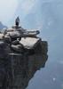
The canyon really opens up on the last day, and it got pretty warm. Although still beautiful, it was hard not to feel that the scenery was a bit more monotonous. For diversion, our hiking was broken up by a pair of paragliders coming down into the canyon off the nearby cliffs. At first, we wondered whether they were planning to just hike out, but then we heard and then saw the helicopter fly in and pick them up. Wonder how much that cost?

We stopped for lunch at the Willis Ranch ruins. Nothing more than a seep of water there, and then continued out the rest of the trip. Took some photos at Lonely Dell Ranch and then finished off the hike.

I found it interesting that one of the most beautiful backpacking trips I have ever done ends with a 1/2 mi. hike on the paved road back to the parking lot ... :-k

We stopped at the Marble Canyon Lodge for hot showers ($2.50 in quarters), then headed to Flag for dinner and on to the Valley that evening.

What a fantastic place and a wonderful trip. Glad to have enjoyed some quality "unplugged" time with my family. Great memories. :y:

I think I literally took 1,000 photos. When I pare them down a bit, I'll post them.
_____________________
  2 archives
Oct 03 2016
avatar

 Guides 4
 Routes 5
 Photos 3,377
 Triplogs 783

55 male
 Joined Aug 20 2009
 Mesa, AZ
Wire Pass to Buckskin GulchSouthwest, UT
Southwest, UT
Hiking avatar Oct 03 2016
RickVincentTriplogs 783
Hiking3.40 Miles 180 AEG
Hiking3.40 Miles
180 ft AEG
 no routes
1st trip
Linked   none no linked trail guides
Partners none no partners
Hoped to get deep into Buckskin Gulch. Ended up deep, but as in waist deep in muddy water. My son was the guinea pig to check the depth of the first pool after the confluence with Wire Pass. Once my daughter saw her brother up to his waist, she refused to go any further. We turned back and went over to the campground by Paria.
_____________________
This is my gym. I have to travel down a bumpy road to get there. There are no treadmillls, no machines, and no personal trainers. I walk..I run..I breathe the fresh air. I can go any time I want, as much as I want and there is no membership fee.
  3 archives
Jun 25 2016
avatar

 Photos 99
 Triplogs 872

male
 Joined Mar 18 2012
 Goodyear, AZ
Buckskin Gulch - Wire Pass to Paria RiverSouthwest, UT
Southwest, UT
Hiking avatar Jun 25 2016
MikeSTriplogs 872
Hiking21.00 Miles 750 AEG
Hiking21.00 Miles   9 Hrs   45 Mns   2.15 mph
750 ft AEG
 no routesno photosets
1st trip
Partners none no partners
I had some buddies that decided to do the Paria Canyon / Buckskin Gulch point to point and asked if I wanted to join in. When people ask me to do big adventures like this one, I don't even know how to say no, so I was in. Best report is I can put together is through video so enjoy my 4 minute video below. Mid-June when temps are 100+ are probably not the most ideal time to do this hike but oh well.

https://youtu.be/Ft ... BJEY
_____________________
Subscribe to my adventure videos at: [ youtube video ]

Follow my adventures on Instagram at: adventures_az
 
May 30 2016
avatar

 Photos 792
 Triplogs 48

64 male
 Joined Nov 29 2009
 Gilbert, AZ
Wire Pass to Buckskin GulchSouthwest, UT
Southwest, UT
Hiking avatar May 30 2016
JohnnieTriplogs 48
Hiking10.00 Miles 180 AEG
Hiking10.00 Miles
180 ft AEG
 no routes
1st trip
Linked   none no linked trail guides
Partners partners
glutz
Greg and I went north to Utah memorial day weekend, our goal was a permit for the Wave but we came up short 3 consecutive days. we had other plans to fall back on. We went to see Toroweap, a long time wish list item for me. we also stopped at horseshoe bend, another one I never went to all these years. We stopped by the north rim while we were in the neighbor hood and hike some of the trails. and last but certainly not least, one of my all time favorites Buckskin Gulch. I won't bore you with long winded descriptions and miles walked. please enjoy the photos
 Fauna
 Fauna [ checklist ]
[ checklist ]  Gopher Snake
_____________________
 
Mar 26 2016
avatar

 Guides 171
 Routes 253
 Photos 6,100
 Triplogs 1,135

44 male
 Joined Apr 03 2006
 Pocatello, ID
Wire Pass to Buckskin GulchSouthwest, UT
Southwest, UT
Hiking avatar Mar 26 2016
PaleoRobTriplogs 1,135
Hiking4.07 Miles 532 AEG
Hiking4.07 Miles   3 Hrs   24 Mns   2.02 mph
532 ft AEG   1 Hour   23 Mns Break5 LBS Pack
 
1st trip
Linked   linked  
Partners none no partners
Jen and I went camping in my old stomping grounds around Page. She'd never been to a slot canyon. We rectified that. The track is a bit wonky since we had to wait on the chokestone downclimb. Seems a fair bit worse than last time I was here (which was 2006 I think).
wildflower observationwildflower observationwildflower observationwildflower observationwildflower observation
Wildflowers Observation Isolated
_____________________
"The only thing we did was wrong was staying in the wilderness to long...the only thing we did was right was the day we started to fight..."
-Old Spiritual
My book, The Marauders on Lulu and Amazon
  1 archive
average hiking speed 2.26 mph
1, 2  Next

WARNING! Hiking and outdoor related sports can be dangerous. Be responsible and prepare for the trip. Study the area you are entering and plan accordingly. Dress for the current and unexpected weather changes. Take plenty of water. Never go alone. Make an itinerary with your plan(s), route(s), destination(s) and expected return time. Give your itinerary to trusted family and/or friends.

helpcommentissue

end of page marker