|
| | | |
| |
|
| Hiking | 7.00 Miles |
587 AEG |
| | Hiking | 7.00 Miles | 2 Hrs 28 Mns | | 2.84 mph |
| 587 ft AEG | | | | |
|
|
| |
| Linked |
|
none
[ show ]
| no linked trail guides |
| Partners |
|
none
[ show ]
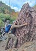
| no partners | | I was a little nervous driving to the trailhead because Alltrails reviews from the past year had mentioned poor conditions. However, I made it to the trailhead just fine with my stock Forester; there was even a Corolla there, too, so the road was great. The day was sunny with some haze and whispy clouds, and the temperature was in the mid-70s. I started the loop counterclockwise. Only about 5 minutes and a quarter mile down the trail, I encountered a gentleman sitting on a log and his off-leash spaniel mix immediately took a disliking to my presence, charging up the trail and barking. I soothed the defensive pooch with kind words of what a good bodyguard it was. The gentleman wasn't too impressed that I was hiking without a gun or bear spray. Whatever, Black Bears are skittish, and if I see a cougar, it wants me to see it. I was more concerned about the calving elk in the area.
I continued down the trail, and shortly before the first shortcut cutoff for the 4-mile option of this loop, I began seeing the historic remnant of cabins, I spotted about 5 cabin remnants from the trail for the next quarter mile or so, and several other remnants of what may have been garden walls or something, I'm not sure. Dammit, Jim, I'm a naturalist, not an archeologist.
Just before the 7-mile shortcut cutoff, I noticed the box canyon mentioned in the trail guide off to my right. It was almost lunch time so I stepped off the trail to the brink and was surprised to find a dry 20 foot waterfall at the head of the box canyon, this place would be awesome during the snow meltoff or after a strong monsoon (probably not this year, sigh). I had lunch on the canyon rim, listening to the canyon wrens, stellar's jays, broad-tail hummingbirds, grosbeaks, and other members of the forest's orchestra perform, and then it was time to move on.
At the 7-mile shortcut cutoff, I went to readjust my boot's tightness, and the lace promptly snapped. Crap, a quick repair job and prayer to whatever deity wanted to help me later, and the second half of the hike was done at a rather quick pace.
I was surprised to find a small brook crossing about a mile before the parking lot in the last part of the loop. It appeared to be a spring that emerged above the trail a short distance before you crossed on a quaint little log bridge. But it had a decent flow and created a nice ambiance in an otherwise relatively dry excursion.
Someday, I'll come back to do the full 9-mile loop. But for now, the 7-mile was satisfactory, and I was pleased with this hike—it did not disappoint! |
|
Wildflowers Observation Substantial
Blue Flag, Globemallow, Paintbrush, Fleabane, Mariposa Lilies, Wild Roses, and several members of the Asteraceae were in bloom. It was a nice selection! |
|
| | |
|
|
|
 Route Editor