username
X
password
register
for free!
help
ArticlesGuidesRoutes
 
Photosets
 
 Comments
triplogs   photosets   labels comments more
Mount Timpanogos - 8 members in 22 triplogs have rated this an average 5 ( 1 to 5 best )
1, 2  Next
22 triplogs
login for filter options
Oct 01 2022
avatar

 Guides 3
 Routes 632
 Photos 8,235
 Triplogs 604

54 male
 Joined Apr 13 2011
 Gilbert, AZ
Mount Timpanogos Explore, UT 
Mount Timpanogos Explore, UT
 
Hiking avatar Oct 01 2022
ddgrunningTriplogs 604
Hiking18.19 Miles 5,201 AEG
Hiking18.19 Miles   10 Hrs   20 Mns   2.07 mph
5,201 ft AEG   1 Hour   33 Mns Break
 
Linked   linked  
Partners none no partners
Route Scout Route Recorded  on Route Scout | Pop | Map | Popup | MapDEX
What a fantastic hike! I have an annual conference in Utah at the end of September and have frequently used it as an excuse to summit Mount Timpanogos, with this being my 4th trip to the summit--2 from the Aspen Grove side, and 2 from the Timpooneke trail. Both approaches are incredible.

This year, I went up from Aspen Grove. In addition to the standard route, I contemplated doing a lasso loop by continuing on past the summit back to where the glacier used to be and going down the steep descent to Emerald Lake. There is a decent route that extends to the where the ridgeline meets the old glacier field, but it gets a bit sketchy in spots and I wasn't comfortable committing to the attempt while hiking solo. So, I backtracked to the summit and then descended as I had come.

On the way down, I circumnavigated Emerald Lake, which lives up to its name and was enhanced in beauty by the clouds flying overhead and reflected on its surface.

From Emerald Lake, I continued off trail to an overlook down to the Hidden Lakes, passing some excellent, secluded camping spots along the way (marked on the gps route). Looking down on the Hidden Lakes, I decided to make another off-trail trip to visit the largest of the lakes on my continued descent. It was a very interesting shade of green. Again, beautiful in reflecting the clouds and surrounding peaks.

The final part of the descent is through the ever growing forest of fall colors. They were really starting to pop, and will likely be at peak in the next week or so.

Passed the upper and lower waterfalls on the final stretch.

Just a gem of a hike, if you are ever in the area!
_____________________
  1 archive
Jul 06 2022
avatar

 Triplogs 1

43 male
 Joined Feb 25 2017
 Mesa, AZ
Mount TimpanogosMountainlands, UT
Mountainlands, UT
Hiking avatar Jul 06 2022
evanlengTriplogs 1
Hiking15.86 Miles 5,698 AEG
Hiking15.86 Miles   10 Hrs   8 Mns   1.77 mph
5,698 ft AEG   1 Hour   9 Mns Break
 no routesno photosets
1st trip
Linked   none no linked trail guides
Partners none no partners
Beautiful hike. Lots of flowers for the first 3/4 of the hike, to Emerald Lake. Snow on the trail for a few hundred yards after the lake.
wildflower observationwildflower observationwildflower observationwildflower observationwildflower observation
Wildflowers Observation Moderate
_____________________
 
Oct 02 2021
avatar

 Guides 3
 Routes 632
 Photos 8,235
 Triplogs 604

54 male
 Joined Apr 13 2011
 Gilbert, AZ
Mount TimpanogosMountainlands, UT
Mountainlands, UT
Hiking avatar Oct 02 2021
ddgrunningTriplogs 604
Hiking14.53 Miles 4,436 AEG
Hiking14.53 Miles   8 Hrs   57 Mns   1.83 mph
4,436 ft AEG   1 Hour    Break
 
Linked   none no linked trail guides
Partners none no partners
Route Scout Route Recorded  on Route Scout | Pop | Map | Popup | MapDEX
Timp is probably the most popular hard hike in the area--and for good reason. It's a gem, especially this time of year, when the fall colors are on full display.

My wife, oldest daughter, and I arrived at the Timpooneke TH around 6:10 a.m. Temps were somewhere in the upper 30s, but with no wind, it was perfect for a hike with a strenuous climb. The 80-space parking lot was about 90 percent full already. This is, in large part, due to a popular tradition to begin the hike early enough to be on the summit to watch the sunrise.

So, despite all the cars, the trail was not overly busy (also, there are a couple of other trails that head out from the same TH). Parking requires a fee payment ($6), though a national park pass works as well.

We hiked by headlamp for the first mile or two. Less water on the trail than when I hiked it a couple of years ago. Scout Falls was a mere trickle.

One of our fellow hikers was packing a "wing" and planned to paraglide from the summit. I crossed paths with his companions on the way down and inquired as to how it went. They said he texted upon his safe arrival at the Landing Zone. Took him 10 minutes from the 11,800 summit. It took us a bit longer ....

We took our time on the ascent and reached the 11,000 ft. Timpanogos Saddle about 11 a.m. My wife and daughter were doing okay physically, but both are afraid of heights and were a little unnerved by some of the exposure on the climb to the saddle. They asked what the exposure was like on the rest of the way to the summit. I'm not too phased by heights, so I told them I didn't think it was worse than what we had experienced so far. After we reached the saddle and looked at the trail to the summit (another 0.75 mi. and 800 AEG), they quickly decided I was terrible at estimating exposure.

As a result, they opted to call the Saddle their turnaround point, but gave me the green light to push on to the summit. And frankly, the Saddle makes a very worth destination in itself, with views on both sides of the ridgeline, including views of Utah Valley and surroundings to the west.

As I climbed, I paid closer attention to the exposure, and it was apparent very quickly that they made the right call. There is a lot of exposure. In addition, that final climb--at altitude--is quite strenuous.

I made the summit about 30 minutes later. Skies were clear and sunny, with excellent views! Cell coverage is great on the summit, and I called down to my wife and daughter. They decided to start their descent. I stayed on the summit, rested, and enjoyed the views for another half hour, and then headed down at a quicker pace, to catch my girls.

On the way down from the summit, I came across a mountain goat just hanging out right on the ridgeline. Cool to see one up close. He wandered off over the edge of the sheer ridgeline--no fear of heights for him!

The descent was uneventful. I caught up to the girls with about 3.5 miles to go. We finished out together and enjoyed the beautiful fall colors surrounding us on every side.

Arriving back at the TH around 2:30, the parking lot was emptier than when we arrived at 6 a.m.

Great hike on a perfect day!
_____________________
  1 archive
Aug 25 2021
avatar

 Guides 99
 Routes 1,484
 Photos 16,072
 Triplogs 1,374

male
 Joined Jan 07 2017
 Fountain Hills,
Mount TimpanogosMountainlands, UT
Mountainlands, UT
Hiking avatar Aug 25 2021
DixieFlyerTriplogs 1,374
Hiking15.10 Miles 4,663 AEG
Hiking15.10 Miles   7 Hrs   57 Mns   2.35 mph
4,663 ft AEG   1 Hour   32 Mns Break
 
1st trip
Linked   none no linked trail guides
Partners none no partners
This was the 6th and last hike that I did over 8 days while on a roadtrip into Utah, Nevada, and Idaho.

I did this one as an out-and-back hike from the Timpooneke Campground/TH.

Most of the hike was a class 1 walk, but there was a bit of class 2 scrambling toward the end.

This is a great hike and I really enjoyed it. I usually don't feel that way about a hike that is fairly heavily traveled.

I did not see many people until I got to a saddle just past where the Aspen Grove Trail meets the Timpooneke Trail. So I guess most people were coming from the Aspen Grove side.

Scenery was great for the entire hike, and Mount Timp is an impressive and dramatic looking peak.

If I lived in the area I am sure that I would do this one at least a couple of times a year.

One thing that struck me was how clean the trail was; by that I mean there was virtually no trash, food waste, etc to be seen. There weren't even any cairns built. If only Arizona trails were so pristine.
 Flora
 Flora [ checklist ]
[ checklist ]  Redberried Elder
 Culture
 Culture [ checklist ]
[ checklist ]  Graffiti
wildflower observationwildflower observationwildflower observationwildflower observationwildflower observation
Wildflowers Observation Moderate
There were several wildflowers blooming along the way
_____________________
Civilization is a nice place to visit but I wouldn't want to live there
  2 archives
Oct 05 2019
avatar

 Guides 3
 Routes 632
 Photos 8,235
 Triplogs 604

54 male
 Joined Apr 13 2011
 Gilbert, AZ
Mount Timpanogos via Timpooneke Trail, UT 
Mount Timpanogos via Timpooneke Trail, UT
 
Hiking avatar Oct 05 2019
ddgrunningTriplogs 604
Hiking15.51 Miles 4,653 AEG
Hiking15.51 Miles   8 Hrs   5 Mns   2.19 mph
4,653 ft AEG   1 Hour    Break
 
1st trip
Linked   linked  
Partners none no partners
Two years ago, I first summitted Timp via the Aspen Grove trailhead. It was a fantastic hike under wintery conditions, but the summit victory was dulled a bit due to it being enshrouded by clouds. So, fast forward to last weekend, I was back for some summit redemption.

This time, even though I was staying at Aspen Grove--a mere 1/4 mile from the trailhead, I wanted to experience the other approach to to the summit, via the Timpooneke Trail. So, along with my son-in-law, we left the Aspen Grove lodge at 5:30 am and made the 20 minute drive on the Alpine Loop around to the Timpooneke TH. It is a popular trail, and even though we arrived before 6 a.m. there were already 20-30 cars in the parking area. It's a thing to hike Timp in the middle of the night, in order to be at the summit for sunrise, so likely, many of those cars had been there since the wee hours of the morning.

In any event, we were on the trail and hiking by headlamp around 5:50 am. The first three miles were in the dark. We passed Scout Falls (the trail actually criss-crosses over it a couple of times), but could only hear it.

As the eastern sky began to show the light of dawn, we had only encountered a couple of hikers and a few trail runners. As opposed to the steeper, Aspen Grove approach, the Timpooneke trail climbs relatively gradually--between 400 and 600 feet per mile. The more gentle grade makes the elevation gain feel a lot easier.

Above the falls, we came to one of a couple of alpine "basins," with more of a meadow-like feel. Around a corner and ascending from that basin, we traversed a long switchback that led to a north-facing drainage which had been choked with ice and snow that had melted from the inside out, leaving a large section of a "snow-tunnel" about 25-30 yards long with a 8-10 foot ceiling. Pretty cool spot that allowed for some wave-cave-like photo opportunities.

Beyond the ice cave, the trail ascends what I think they call the Grand Staircase up to the Timpanogos Basin, where Timp itself comes into impressive view on the southern end.

The trail skirts the basin to the west, though there is an alternate route through the basin that connects more directly to the Aspen Grove approach. We decided to take that alternate trail on our return from the summit.

Continuing up Timpooneke, the trail reaches the Mt. Timpanogos Saddle at around 11,000 ft. where it finally intersects with the Aspen Grove approach. Cresting the saddle is always impressive, as it opens the views to Utah Valley and Utah Lake below. It is also typically where the wind and real cold kicks in.

From the descending sunrise-summitters, we understood that the wind had been pretty strong before sunrise, but by the time we arrived at the saddle, it wasn't much more than an occasionally stiff breeze. Very pleasant by comparison with my experience two years ago.

There was a lot more traffic on the trail at the saddle, but no conga line.

The ascent to the summit was fun and filled with magnificent views on each side of the summit ridgeline. We saw a handful of mountain goats, grazing on the mountainside below, but the battery on my camera with the good zoom had died, so no good photos ...

At the summit itself, there are several perches on the north/east facing side that provided ideal resting spots in the sun and are protected from the breeze. We ate brunch, relaxed in the sun, and enjoyed the views.

We wandered past the summit towards the glacier and saw a solitary climber ascending the glacier. Looked cool.

After 30-40 min on the summit, we made our descent. At the saddle, we took the alternate route down towards the Aspen Grove trail, which required our only snow crossing of the day, as the field of snow on the north side of the mountain, directly below the summit had not melted. The snow was hard-packed and we managed fine without any traction devices.

While we were in the vicinity, we continued "around the corner" to take a peek at Emerald Lake and the glacier from below. (This corner was the sketchiest part of my hike two years ago, covered with snow and with a lot of exposure). While observing the view of Emerald Lake and the glacier, we watched a snowboarder descending the glacier, and clearly having a great time. I thought I caught it on video, only to realize at the end when I was pushing "stop" on the recorder that I was actually pushing "start"--so I missed capturing it. Oh well.

We then backtracked to a ramp down to, and across, the Timpanogos Basin. The trail was semi-soggy in a few spots, but no big deal.

Once reconnected to the Timpooneke trail proper, we cruised on the descent. The last few miles of a long hike can often drag on, but we were in for a surprising treat. All of the area we hiked through in the darkness on the way up was a cornucopia of eye-popping fall colors on the way down. And Scout Falls was an impressive sight to take in as well. Up to that point, I was inclined to give the Aspen Grove trail the nod as to which is better, but this section made it a closer call. Really, there is no bad choice--with a shuttle option being the best of both worlds.

There is a reason this is one of the most popular, hard hikes in the area. Definitely a crowd pleaser and worth putting on a regular rotation.
 Meteorology
 Meteorology [ checklist ]
[ checklist ]  Autumn - Color Foliage  Clear Ice
_____________________
  1 archive
Aug 18 2018
avatar

 Guides 5
 Routes 29
 Photos 605
 Triplogs 880

55 male
 Joined Mar 05 2011
 Pocatello, ID
Mount TimpanogosMountainlands, UT
Mountainlands, UT
Hiking avatar Aug 18 2018
WoodsnativeTriplogs 880
Hiking11.50 Miles 4,000 AEG
Hiking11.50 Miles
4,000 ft AEG
 no routes
Linked   none no linked trail guides
Partners none no partners
A warm day in the valley, but cool above 10,000 feet. Lots of hikers, since it was a Saturday. The mountain goats were much lower, and had several close encounters with humans. We were eating our lunch at the stone cabin near Emerald Lake, and along came a goat right behind us. The season was so dry, that the lake was divided in two, with a rock 'causeway' through the middle of it. The glacier had only one spot of snow in the upper section, and one ravine of snow near the lake, which was sad to see.
_____________________
If you don't run, you rust.
-T. Petty
  1 archive
Sep 30 2017
avatar

 Guides 3
 Routes 632
 Photos 8,235
 Triplogs 604

54 male
 Joined Apr 13 2011
 Gilbert, AZ
Mount TimpanogosMountainlands, UT
Mountainlands, UT
Hiking avatar Sep 30 2017
ddgrunningTriplogs 604
Hiking15.20 Miles 5,231 AEG
Hiking15.20 Miles   8 Hrs   41 Mns   1.94 mph
5,231 ft AEG      52 Mns Break
 
Linked   linked  
Partners none no partners
Wow! This is an awesome hike! A little of everything--beautiful fall colors; multiple waterfalls; challenging AEG; alpine lakes; glacier; some pucker factor along a snowy traverse; knife-ridge; and, of course, a summit with expansive views (albeit, on this day, limited by low cloud cover).

After scouting out the first 1.5 miles of the trail following the conclusion of my conference at Aspen Grove the prior afternoon, I was ready for a pre-dawn ascent up the trail.

I had booked an extra night at Aspen Grove for this purpose, and after all of the conference goers left, I literally had the place to myself (not even any staff around--a phone number was posted on the door of the lodge to call if I needed assistance). Not gonna lie, it was a little eerie. I was wondering when Jack Nicholson would be rounding the corner with axe in hand. :scared:

Thankfully, no boogie men appeared, and I awoke at 5 am, got a little nutrition in, packed up my room and headed out into the darkness.

The lodge is about 0.25 mi. from the trailhead, so I just walked up the road and off onto the trail.

The first couple of miles were in the dark. About a mile in, I approached the first waterfall. Couldn't see much, but certainly heard it. Another half mile, another waterfall.

By that point, I had gained a good 800 feet and could look down the valley and see some lights from Aspen Grove and the surrounding area. Up above, I could make out some headlamps of folks who camped overnight and were getting ready for a summit attempt.

Another mile or so on the trail and the horizon began to lighten a bit. The forecast was for overcast skies and possible rain, so I didn't have high expectations for a spectacular sunrise. It was brief indeed, but provided a couple of minutes of decent color before the sun was enveloped in the cloud cover.

The cloud ceiling was still above 12K at that point, providing some good visibility of Deer Creek Reservoir and the town of Heber off to the Northeast.

About 3 miles or so in, I hit my first snow on the trail around 9,800 feet. I pulled out my Yax Trax and was happy to have the extra traction, as the sun the day before had resulted in some melt/freeze conditions. Up to that point, I had been hiking in shorts and a shirt, trying to keep cool. At this point, I layered up a bit and zipped on the pant legs.

Just shy of 5 miles, I rounded the corner on the Hidden Lakes area, covered in a layer of snow. Caught a blurry photo of a grouse(?) and briefly chatted with a guy who had overnighted in the area and was planning a summit attempt.

From Hidden Lakes, the trail curves to the NE, between an outcropping on the SE and Robert's Horn to the NE. With the snowy conditions, I lost track of the actual trail for a bit and was bushwhacking it through the snow up a a short incline, until I noticed the actual trail reappear and I cut over to rejoin it.

After going up a short rise, the Emerald Lake Shelter Hut came into view. Emerald Lake is directly south of the structure and was divided into a thawed section and a frozen section, which sits at the bottom of the glacier. I'm not sure it still qualifies as a "glacier," as I've seen several photos where the ice/snow is pretty sparse. On this day, though, there was a good amount of snow for end of September. In the past, it apparently has been popular to glissade down the glacier back to the Lake after summitting. It's not recommended now, as the chances of crashing into rocks is apparently pretty high.

From the shelter, you can also see make out the summit hut, less than a 1/2 mile as the crow flies, and about 1,400 feet up, surrounded by sheer cliffs. The trail takes nearly another two miles to get there.

Just beyond Emerald Lake was the sketchiest part of the trail, requiring a 3/4 mile traverse across a knee deep snow field, which in a few sections involve some fairly steep angles where a slip and fall would not turn out well ...

Thankfully for me, there had been a few hikers through the area already, leaving some postholes for me to strategically place my footing. I'm not sure how much of this section I was on the actual "trail," as it was a little difficult to discern, though the ultimate destination on the far side of the field was clear.

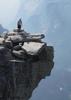
As the far end of the snow field, the trail climbed a steep ramp to where it intersected with the Timpooneke trail (an alternative approach to the summit) just below a "saddle" providing the first glimpses to the south and west into the the Provo Valley and Utah Lake from 11,000 feet up. Beautiful views! Thankfully, although the cloud level continued to lower, I was still able to see the city, lake, and a lot of the fall foliage on the lower reaches of the mountain.

The other thing that immediately grabbed my attention upon crossing the ridgeline was the WIND! It was pretty fierce. At this point I put on the windbreaker and gloves and buckled in for 3/4 mi.final climb.

The trail in this section is cool, skirting just along the edge of the knife-like ridgeline. As I ascended, the cloud level continued to lower, and soon the summit was shrouded in clouds. I was a little bummed about that, as I'm sure the views on both sides of the ridgeline are spectacular on a clear day. Oh well, a good reason to go back again.

About 1/2 mile from the summit, the trail climbs steeply up a break in the rock, along several tight switchbacks, before resuming its ascent just below the ridgeline.

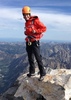
At this point, I was hiking in the clouds with very limited visibility and didn't see the summit hut until it was 10-15 yards in front of me.

I was happy to reach the summit, but again slightly bummed about not being able to enjoy the views. Still, the summit adrenaline rush kicked in, and I was also glad to hunker in the hut and get a little reprieve from the wind.

After a few calories, and entry into the summit log and putting on my final layer (a thermal shirt) for the descent, I headed back into the clouds for the return trip.

The wind blew mercilessly over he summit ridgeline, creating a cool visual effect with the clouds "shooting" over the lip of the mountain.

When I finally crossed back over and below the ridgeline, the wind immediately ceased and the snow-covered trail was amazingly tranquil. A light snow began to fall as I traversed back across the snow field.

Once below 9,800 feet, and leaving the snow behind, I was in awe of the beautiful fall colors. Couldn't stop taking pictures.

By the time I returned to my starting point, I looked up and could see that the summit clouds had lifted and it was now clear on top. Oh well ....

Bottom line: This was easily a top 10 hike in my book. Highly recommend it to anyone in the area.

I'll be back on another--clear--day to enjoy the mountain again with full views!
 Culture
 Culture [ checklist ]
[ checklist ]  Benchmark
 Named place
 Named place [ checklist ]
[ checklist ]  Mount Timpanogos
_____________________
 
Sep 29 2017
avatar

 Guides 3
 Routes 632
 Photos 8,235
 Triplogs 604

54 male
 Joined Apr 13 2011
 Gilbert, AZ
Mount TimpanogosMountainlands, UT
Mountainlands, UT
Hiking avatar Sep 29 2017
ddgrunningTriplogs 604
Hiking3.02 Miles 943 AEG
Hiking3.02 Miles   1 Hour   8 Mns   2.79 mph
943 ft AEG      3 Mns Break
 
Linked   none no linked trail guides
Partners none no partners
My conference at Aspen Grove ended at 3:30 pm, and I decided to do a quick afternoon "test run" up the first mile and half of the Mt. Timpanogos trail in preparation for my hike to the top on the following day. I had spent most of the conference that day staring out the windows at the mountains and chomping at the bit to get out on the trails.

As I had never done the trail before and would be starting out before dawn with about 90 minutes of trail time in the dark, I wanted to make sure I knew where I was going and wouldn't have any issues navigating in the dark. Plus, today was a beautiful day, with clear blue skies, and the following day was forecast to be cloudy with a chance of rain/snow. So, I wanted to take in the views, particularly on this first section of the trail which I wouldn't see much of at o-dark-thirty the following morning.

Wow. Talk about a teaser! About one mile from the trailhead, I hit the first waterfall. Gorgeous! another half mile up was the next set of falls. Equally gorgeous. I climbed a bit past that to an opening on the beautiful fall colors on the drainage below. I wanted to go further, but needed to head back down to Provo for a dinner appointment.

Definitely pumped for doing the full 15 mile trail the following morning ....
_____________________
 
Jul 30 2016
avatar

 Photos 6
 Triplogs 7

male
 Joined Feb 19 2016
 Mesa
Mount TimpanogosMountainlands, UT
Mountainlands, UT
Backpack avatar Jul 30 2016
valvelessTriplogs 7
Backpack12.00 Miles 3,000 AEG
Backpack12.00 Miles   12 Hrs      1.00 mph
3,000 ft AEG
 no routes
1st trip
Linked   none no linked trail guides
Partners none no partners
The Summer of Hiking --- all over the place! A last minute decision to spend the night below the summit of Mount Timpanogos was made as I was driving in to UT and saw it looming in the distance, remembered the fun I had up there in my younger days, and wanted something to break the monotony of an 8 hour trip across NV. I literally unpacked the car, got the wife and kids situated with their cousins, backed a backpack, and was off. A late start at 4:30pm but I knew the trail and wasn't concerned. The Aspen Grove trail to the summit is a well graded sequence of switchbacks up a very steep piece of ravine. The waterfalls and wildflowers were turned up to maximum. An earlier thunderstorm had left the air warm and humid. The magic increased when I arrived at the sequence of meadows below the glacial fed Emerald Lake to find an entire herd of wild goats munching on the verge surrounding the trail. Numerous backpackers had set up their tents to face this idyllic scene. I made a bivy near the edge of a ledge overlooking a lower sequence of lakes, the cirque that forms the base of the summit, and the Uinta range in the distance. Distant thunderstorms entertained me during a quick dinner, interrupted only by a momma and her kid who chose to walk right through my little camp. With rain seeming imminent, I made hasty clean-up, got the pack covered, jumped in to my bivy and battened down the hatches. Brief but intense bouts of rain and wind interrupted my sleep a couple of times during the night -- the pleasure of a bivy is found in the hike up the mountain, the curse, when you have to hole yourself up against rainy weather, making sure the top flap always extends over the bottom flap lest your whole bivy fill with water! This inconvenience notwithstanding, the cool air and raging wind were a welcome change from the heat that accompanied us in our recent trip to Yosemite. Over 100 degrees there! Here, it probably got down to the 50s and I snuggled up and fell asleep to the sounds of rain hitting the bivy directly above my ear, and the wind ripping at the fabric. And for all the bivy naysayers out there, I awoke dry and happy with the sunrise and headed back down the mountain in order to get to the airport in time to retrieve my mother-in-law :D
wildflower observationwildflower observationwildflower observationwildflower observationwildflower observation
Wildflowers Observation Extreme
_____________________
 
Jul 12 2016
avatar

 Guides 5
 Routes 29
 Photos 605
 Triplogs 880

55 male
 Joined Mar 05 2011
 Pocatello, ID
Mount TimpanogosMountainlands, UT
Mountainlands, UT
Hiking avatar Jul 12 2016
WoodsnativeTriplogs 880
Hiking14.00 Miles 5,430 AEG
Hiking14.00 Miles   10 Hrs   30 Mns   1.87 mph
5,430 ft AEG   3 Hrs    Break
 no routes
Linked   none no linked trail guides
Partners none no partners
Saw over 30 mountain goats, and one ran past us in the little valley just before the cabin. One of our young hikers caught a Pokemon at the summit. I was glad he was inside the shack at the time, so that he didn't fall off the cliff! The glacier was nearly melted at the top; it is shaping up to be a dry year.
wildflower observationwildflower observationwildflower observationwildflower observationwildflower observation
Wildflowers Observation Substantial
_____________________
If you don't run, you rust.
-T. Petty
 
Aug 14 2015
avatar

 Guides 2
 Routes 251
 Photos 4,593
 Triplogs 3,212

63 male
 Joined Feb 26 2008
 Scottsdale, AZ
Mount TimpanogosMountainlands, UT
Mountainlands, UT
Hiking avatar Aug 14 2015
BobPTriplogs 3,212
Hiking16.17 Miles 5,265 AEG
Hiking16.17 Miles
5,265 ft AEG
 no routes
1st trip
Linked   linked  
Partners none no partners
Nick told me if Mt. Timp was a woman; he would marry her. Fun hike in a great area. Added on Roberts Horn because its there. I used the Stewart Falls Trail as a warmup. I'll post a gps route and photos next week.
 Fauna
 Fauna [ checklist ]
[ checklist ]  Mountain Goat
_____________________
https://www.seeitourway.org
Always pronounce Egeszsegedre properly......
If you like this triplog you must be a friend of BrunoP
 
May 23 2015
avatar

 Photos 99
 Triplogs 872

male
 Joined Mar 18 2012
 Goodyear, AZ
Mount TimpanogosMountainlands, UT
Mountainlands, UT
Hiking avatar May 23 2015
MikeSTriplogs 872
Hiking13.50 Miles 3,970 AEG
Hiking13.50 Miles   5 Hrs   7 Mns   3.73 mph
3,970 ft AEG   1 Hour   30 Mns Break
 no routesno photosets
1st trip
Linked   linked  
Partners none no partners
I was in Utah for a wedding yesterday so I thought I would try my luck with Timpanogos today. I knew it was very early in the year and it still had lots of snow on the peak and had been falling the last couple weeks. It was also supposed to storm today but I am not really smart enough for those things to stop me. I started early and it was below 30. The sun was coming up and going up hill I started peeling layers off a mile into the hike. I had heard this was a great hike and even though I went to school there I never did it in college. I could not believe how scenic it was. Absolutely beautiful. The first 2.5 miles the trail was very wet but not a problem. Once I got to 3 miles I started walking on a lot of snow. The next half mile took me almost 30 minutes and it started getting steep and slick. I kept on losing and refinding the trail but it go to hard to follow. Also being by myself, I did not want to get to crazy so I turned back. As soon as I did the storm rolled in and it started snowing. Going down was pretty fast. Once I got back to the trail head I dumped some extra clothes and headed down the Cascade Springs trail. Beautiful waterfall. I then went an extra 1.5 miles over to Sundance then returned. Great day. I love our Arizona trails but I wish I could go on more of these Rocky Mountain hikes, amazing scenery.
_____________________
Subscribe to my adventure videos at: [ youtube video ]

Follow my adventures on Instagram at: adventures_az
 
Feb 27 2015
avatar

 Photos 312
 Triplogs 55

37 female
 Joined Dec 02 2012
 Phoenix,AZ
Mount TimpanogosMountainlands, UT
Mountainlands, UT
Hiking avatar Feb 27 2015
Gardka31Triplogs 55
Hiking7.00 Miles 5,430 AEG
Hiking7.00 Miles
5,430 ft AEG
 no routes
1st trip
Linked   none no linked trail guides
Partners none no partners
Climbed Big Baldy, descended to Baldy saddle & traversed to a couloir that connected to Everest Ridge to ascend Mt Timpanogos (55degree slopes, class 4)...got to the crux just 1,500' & 0.7mi from the summit, whiteout conditions & scary fierce winds prevented summit of Time (which would have netted about 7,650' vert gain)
_____________________
:y:
"All our dreams can come true, if we have the courage to pursue them." 
— Walt Disney

"People often say that motivation doesn't last. Well, neither does bathing that's why we recommend it daily." 
— Zig Ziglar
  1 archive
Jul 20 2014
avatar

 Triplogs 348

32 male
 Joined Oct 13 2012
 Tucson, AZ
Mount TimpanogosMountainlands, UT
Mountainlands, UT
Hiking avatar Jul 20 2014
iborregoTriplogs 348
Hiking15.00 Miles 4,580 AEG
Hiking15.00 Miles   5 Hrs      3.00 mph
4,580 ft AEG
 no routesno photosets
1st trip
Linked   none no linked trail guides
Partners none no partners
_____________________
 
Jul 03 2013
avatar

 Guides 5
 Routes 29
 Photos 605
 Triplogs 880

55 male
 Joined Mar 05 2011
 Pocatello, ID
Mount TimpanogosMountainlands, UT
Mountainlands, UT
Hiking avatar Jul 03 2013
WoodsnativeTriplogs 880
Hiking14.00 Miles 5,430 AEG
Hiking14.00 Miles   11 Hrs      1.65 mph
5,430 ft AEG   2 Hrs   30 Mns Break
 no routes
Linked   none no linked trail guides
Partners none no partners
Hiked the lasso loop from Aspen Grove Trailhead up to the peak and then down the glacier. The 4 kids I took with me (ages 11 to 15) did great, and liked skiing down the snow the best. We took a lot of breaks going up, and that took 7 hours. Going down we hurried and finished in 4 more hours. This time instead of mountain goats we saw 3 bighorn sheep right near the lake. The weather was on the hot side with very little wind. Part of the trail is still under snow along the north slope.
 Fauna
 Fauna [ checklist ]
[ checklist ]  Bighorn Sheep
 Culture
 Culture [ checklist ]
[ checklist ]  Campsite
 Meteorology
 Meteorology [ checklist ]
[ checklist ]  Glacier
wildflower observationwildflower observationwildflower observationwildflower observationwildflower observation
Wildflowers Observation Substantial
_____________________
If you don't run, you rust.
-T. Petty
 
Aug 14 2012
avatar

 Guides 13
 Routes 38
 Photos 1,651
 Triplogs 577

60 male
 Joined Nov 15 2005
 Jackson, CA
Mount TimpanogosMountainlands, UT
Mountainlands, UT
Hiking avatar Aug 14 2012
toddakTriplogs 577
Hiking21.00 Miles 5,800 AEG
Hiking21.00 Miles   10 Hrs      2.10 mph
5,800 ft AEG
 no routes
1st trip
Linked   none no linked trail guides
Partners none no partners
Fantastic hike starting at the Aspen Grove trail head, with steady climbing through lovely alpine scenery to a classic summit. Continued south along the summit ridge to a saddle above the Timp "Glacier", glissaded quickly down to Emerald Lake, then exited north to the Timpooneke trail head. From there a series of multi-use trails (150, 159 and 055) circle around the NE side of the wilderness back to the Aspen Grove trail head, making for a killer loop!
_____________________
 
Jul 05 2012
avatar

 Guides 5
 Routes 29
 Photos 605
 Triplogs 880

55 male
 Joined Mar 05 2011
 Pocatello, ID
Mount TimpanogosMountainlands, UT
Mountainlands, UT
Hiking avatar Jul 05 2012
WoodsnativeTriplogs 880
Hiking6.80 Miles 2,100 AEG
Hiking6.80 Miles
2,100 ft AEG
 no routes
Linked   none no linked trail guides
Partners none no partners
This was my last full day in Utah and so even though the weather forecast called for rain, I started off up Timpanogos with my nephew, for his first time on the mountain. If we timed it right, we could make the cabin shelter near Emerald Lake, wait for the rain to pass, and then reach the summit. It wasn't meant to be.

As soon as our ride dropped us off above Aspen Grove, we could see raindrops falling. They were less than a sprinkle and the air was warm, so we weren't deterred. Yet. We counted ten different waterfalls one above the other and were excited to pass them and the patches of snow in the distance. A light rain began to fall as we ascended past the first and second waterfalls. An hour and a half later, the clouds covered us for good. A light rain continued, and increased as we climbed. After 2.5 hours and 3.5 miles up the trail, we decided to call it a day and go back. We were a bit lacking in the raingear department (windbreakers and garbage bags weren't cutting it) and knew there would be no view from the summit due to the heavy cloud cover anyway. Suprisingly, my phone had service, so I called for our ride to come early, and to bring some towels!

Just as I finished the call, a rock slide let loose somewhere in the fog. At first it sounded like a tree falling. We heard crashing and cracking sounds for at least 30 seconds with a few straggling rocks coming after. It was almost spooky to hear it and not see it. All we could do was look at each other and the whiteness surrounding us, and hope that nobody got hurt. We found out later that the slide did not cross the trail thanks to several switchbacks that skirted the rockslide area.

I'll post a few photos we took with a borrowed camera, but most of these did not turn out well. The flowers were amazing in variety and in size, but our camera didn't really do them justice. I also noted that one of the middle waterfalls has room for a person to walk behind it. I need to plan a return visit to take better pictures of the beauty of this mountain (and to reach the summit).
 Flora
 Flora [ checklist ]
[ checklist ]  Fireweed
wildflower observationwildflower observationwildflower observationwildflower observationwildflower observation
Wildflowers Observation Substantial
_____________________
If you don't run, you rust.
-T. Petty
 
Jun 09 2012
avatar

 Routes 26
 Photos 1,288
 Triplogs 124

66 male
 Joined Oct 28 2003
 Andover, NJ
Mount TimpanogosMountainlands, UT
Mountainlands, UT
Hiking avatar Jun 09 2012
big_loadTriplogs 124
Hiking10.90 Miles 2,822 AEG
Hiking10.90 Miles   6 Hrs   27 Mns   1.69 mph
2,822 ft AEG
 
no photosets
1st trip
Linked   none no linked trail guides
Partners none no partners
I got off to an inauspicious start, with a flat tire half a mile into the park. An hour later I was back with a fresh paw, and proceeded to the trailhead. I should have consulted my hiking GPS (which had stored waypoints) instead of my phone GPS, or I would have known it was the wrong one.
As I trudged merrily down the trail, it occurred to me that "down" didn't make much sense. I soon deduced (with the aid of a sign) that it was only 2.5 miles and 1,000 feet down Trail 55 to where I really wanted to start. However, the cool breeze in the aspens lulled me into acceptance of the trip down and the eventual trip back, on top of my original plan, which was to hike Trail 52.

Trail 55 came out of the trees onto Trail 52near the base of the 4700 ft headwall. There were several groups enjoying the two lower sets of waterfalls, but the crowds thinned out before the absurdly long switchbacks. I got up into the snow, and crossed half a dozen snowfields before I decided it was far enough. What convinced me was the sound of roaring water beneath the snow bridge I was standing on. I found a shady patch of rose bushes to ogle the countless waterfalls and enjoy lunch before heading back.
_____________________
 
Oct 03 2011
avatar

 Guides 170
 Routes 148
 Photos 5,914
 Triplogs 2,097

48 male
 Joined Apr 12 2004
 Tucson, AZ
Mount TimpanogosMountainlands, UT
Mountainlands, UT
Hiking avatar Oct 03 2011
PrestonSandsTriplogs 2,097
Hiking14.59 Miles 5,148 AEG
Hiking14.59 Miles   8 Hrs      1.82 mph
5,148 ft AEG18 LBS Pack
 no routes
1st trip
Linked   none no linked trail guides
Partners partners
fricknaley
After a long and scenic road trip the day before, we got up well before dawn and hit the highway out of Provo. We cruised through Sundance and picked up Robert Redford, who was dressed as Jeremiah Johnson for our amusement. We hit the trail at dawn and entered a chilly canyon full of blazing aspens and maples, guarded by high cliffs. The scenery was incredible and only got better as we climbed. Waterfalls, avalanche chutes, rugged peaks and beautiful forest: oooh! :DANCE:

At last the mighty peak of Timpanogos itself came into view, as we entered the treeless bowl of Timpanogos Basin. We trudged past a sea of blooming lupines, and soon reached the ridge overlooking Provo many thousands of feet below. The chilly wind and clouds raced past us as we climbed the rugged upper slopes on an amazing stretch of trail carved into the mountain. A stairway to heaven of sorts. We lingered a while at the summit enjoying a view so awesome words cannot do it justice. After many photos were taken it was time to head back down.

Dropping off of the summit ridge, Nick suggested we take a small detour through Timpanogos Basin across a snowfield below the massive north face of Timpanogos. The detour route proved outstanding, with huge cliffs above, snow beneath our feet, and wildflowers spread out below. Wow!!! We took our time on the hike back to the trailhead, stopping for every jaw dropping beautiful scene (of which there were plenty).

Thoroughly stoked after our incredible hike, we took the long way back, through American Fork Canyon, stopping at Timpanogos Cave National Monument (which was closed, unfortunately). Back in Provo we went in search of and found some great pizza, and planned the next day's hike to another mighty mountain summit.

One of the best hikes I have ever been on! Good times, Nick! :D
_____________________
"…you never know when a hike might break out" -Jim Gaffigan
 
Oct 03 2011
avatar

 Guides 93
 Routes 397
 Photos 4,984
 Triplogs 4,124

49 male
 Joined Jun 20 2003
 Tucson, AZ
Mount TimpanogosMountainlands, UT
Mountainlands, UT
Hiking avatar Oct 03 2011
fricknaleyTriplogs 4,124
Hiking14.59 Miles 5,148 AEG
Hiking14.59 Miles   8 Hrs      1.82 mph
5,148 ft AEG20 LBS Pack
 
1st trip
Linked   none no linked trail guides
Partners partners
PrestonSands
preston and i were originally planning on going to colorado to hit some tall peaks but the forecast became horrid so we switched plans and decided to hit the Wasatch mountains instead. kept our eye on the forecast (which also was becoming worse and worse) and decided to just go, give it a try and see what happens.

nice drive up through Page and Kanab with great views of red rock country then big utah mountains in fall prime time color.

with the forecast becoming worse by the day we decided to hit Mt. Timpanogos first, as this was the one we really didn't want to miss. We decided to do it via the Timpooneke trail as we learned this is generally considered the more scenic route. we started just before sunrise to optimize our chances of staying dry and it was cold. dropped my phone in the parking lot and broke it...who cares i just wanted to start this exceptional hike. i'd worry about that later.

almost immediately we were immersed in intense fall color as we wandered through huge amounts of maple and aspen, crossing several small waterfalls cascading over the trail. after a bit we hit the cleared out Timpanogos shelf and were treated to wonderous views up high of the northern Timpanogos ridge line, snow fields and looking back east into the green, orange and yellow wasatch. Huge canyon walls towered overhead. this spot is spectacular. from here we went up more through a small stretch of conifers then above timberline to the Timpanogos basin, a tundra wonderland still filled with late summer flowers and majestic views of the summit of Timp and several small snowfields along it's base.

this is what we came to see and my, oh my, did it fulfill all it's promise :y:

from here we switchbacked up to the ridgeline saddle where views to the west over Provo and Utah lake came in to play.

the final stretch had us zig zagging up the rocky and often quite exposed summit to the top where some of the best views i have ever seen were awaiting. spent some good time on the summit, though cold, taking it all in.

took a little variant on the way down, crossing over some of the snow fields and a small trail cutting through the heart of the Timpanogos basin - filled with flowers. glad we did this as this small stretch is some of the best trail i've ever hiked.

the weather was perfect all day and this hike, for me, was world class and one of the absolute best i've ever done.
foliage observationfoliage observationfoliage observationfoliage observationfoliage observation
Autumn Foliage Observation Substantial
wildflower observationwildflower observationwildflower observationwildflower observationwildflower observation
Wildflowers Observation Moderate
_____________________
hi
 
average hiking speed 1.99 mph
1, 2  Next

WARNING! Hiking and outdoor related sports can be dangerous. Be responsible and prepare for the trip. Study the area you are entering and plan accordingly. Dress for the current and unexpected weather changes. Take plenty of water. Never go alone. Make an itinerary with your plan(s), route(s), destination(s) and expected return time. Give your itinerary to trusted family and/or friends.

helpcommentissue

end of page marker