username
X
password
register
for free!
help
ArticlesGuidesRoutes
 
Photosets
 
 Comments
triplogs   photosets   labels comments more
Mount Taylor - 5 members in 13 triplogs have rated this an average 4.6 ( 1 to 5 best )
13 triplogs
login for filter options
Aug 06 2025
avatar

 Guides 104
 Routes 256
 Photos 16,118
 Triplogs 528

53 male
 Joined Dec 30 2005
 Tucson, AZ
Mount TaylorNorthwest, NM
Northwest, NM
Hiking avatar Aug 06 2025
Mike_WTriplogs 528
Hiking5.85 Miles 1,639 AEG
Hiking5.85 Miles   4 Hrs   13 Mns   2.03 mph
1,639 ft AEG   1 Hour   20 Mns Break
 
1st trip
Linked   none no linked trail guides
Partners none no partners
Note: my stats also include hiking to La Mosca Lookout, elev 11,036.

This was a very enjoyable hike, loved it!!! I started in a forested area with some aspens and pines. After hiking less than a mile there was a clearing and I was getting close to a saddle. From this saddle I could see the fire lookout tower behind me and Mt Taylor straight ahead. After hiking 1.15 miles you will get to a junction in the road. At this junction, there is a trail leading straight, going up to the Mt Taylor summit called the Gooseberry trail. You should see a sign there. I took that very nicely maintained trail up. There were a few steep areas but overall, it was a nice trail that took me around a smaller peak to another small saddle. At this saddle, I crossed another forest service road (FS 570) and continued on the trail. It was just a few switchbacks more and I was at the summit. There was a nice summit sign and amazing views in all directions. I could see rain clouds to my South and North but nothing looked too close. The temps were extremely comfortable and felt like high 60s. About 10 minutes after I was at the summit, another couple summited from the other side of the Gooseberry trail. They had a very nice golden retriever with them! I didn't even realize there was another extension coming from the other side. We chatted for 15 or 20 minutes and they headed down the same way. I stayed up on the summit for another 15 minutes to have a quick lunch.

Next, I headed back down to the saddle between Mt Taylor and the fire lookout tower. I had energy and time so I decided to walk the road to the lookout tower. At the top, I found the La Mosca Lookout, elev 11,036. I saw a white pickup truck at the top, but didn't see anyone manning the tower or working with the radio towers up there. Maybe they were taking an afternoon nap ;-). All in all, this was an excellent hike, especially to get away from the heat!!

Stats:
-------
5.85 miles round trip
1639 feet AEG
strava moving time 2 hrs 53 mins
strava elapsed time 4 hrs 13 mins

Driving directions
--------------------
From Gallup, NM

Follow I-40 E to NM-122 W/NM-53 E in Grants. Take exit 81B from I-40 E
50 min (59.2 mi)

Merge onto NM-122 W/NM-53 E, continue for 0.3 mi
Turn right onto W Santa Fe Ave/U.S. Rte 66, continue for 1.4 miles
Turn left on 1st Street, continue for 0.8 miles
Use the right 2 lanes to turn right onto E Roosevelt Ave, continue for 0.4 mi.
Turn left onto NM-547 N/Lobo Canyon Rd. Continue to follow NM-547 N for 15.1 mi.

Turn right onto Forest Service 453 Rd/La Mosca Lookout Rd (sign has graffiti and is hard to see!)
Continue for 3.0 miles to an area labeled 'Spruce Tank' on Google Maps

If you have high clearance or 4x4 and good tires, you can continue another 0.4 miles to the next switchback or even drive further if you want. I parked at the next switchback which was a great place to start in my opinion.
_____________________
Michael Williams
IT Professional
Rocky Point Vacation Rentals
Ocean Front Condo in Rocky Point, Sonora, Mexico
www.beachfrontmexico.us
Image
 
Jul 04 2025
avatar

 Guides 12
 Routes 192
 Photos 863
 Triplogs 356

42 male
 Joined Nov 30 2015
 Phoenix, AZ
Mount TaylorNorthwest, NM
Northwest, NM
Run/Jog avatar Jul 04 2025
ShatteredArmTriplogs 356
Run/Jog6.25 Miles 1,972 AEG
Run/Jog6.25 Miles   1 Hour   58 Mns   50 Secs3.21 mph
1,972 ft AEG      2 Mns Break
 no routesno photosets
1st trip
Linked   none no linked trail guides
Partners none no partners
Headed up to Taos, and wanted to finally check off Mt Taylor on the way. It was the last of the Navajo Four Sacred Mountains that remained unclimbed by me. Unfortunately, had a dead battery situation, so had to borrow my sister's truck...but we had to go buy cables so I could actually get my Jeep out of the way, which created about an hour's delay overall... Fortunately, I had a favorable weather forecast, which partially mitigated my concerns about a late start...

Got to Gooseberry TH at around 11:45AM. The first part of the trail was a mellow grade through mixed forests. Most of the aspens below about 9800 or so were really struggling. Get a bit steeper above 10k, where you also enter a nice grassy meadow that provides nice views the rest of the way up. Saw a handful of hikers coming down.

The summit was nice, and the weather was still stable. On the way down, I decided to see if I could pick off any of the hikers I had seen on the way up, which I did at around 10k. This was a fun mountain, and a nice little two hour break from driving. Of the four mountains, this was by far the easiest.
_____________________
 
Oct 05 2024
avatar

 Guides 2
 Routes 512
 Photos 5,579
 Triplogs 4,278

69 male
 Joined Mar 01 2009
 Aztec, NM
Mount TaylorNorthwest, NM
Northwest, NM
Hiking avatar Oct 05 2024
PivoTriplogs 4,278
Hiking6.33 Miles 1,947 AEG
Hiking6.33 Miles   3 Hrs   54 Mns   1.94 mph
1,947 ft AEG      38 Mns Break15 LBS Pack
 
Linked   none no linked trail guides
Partners partners
GrottoGirl
MyRudy
Nice morning hike with some Fall color.
foliage observationfoliage observationfoliage observationfoliage observationfoliage observation
Autumn Foliage Observation Moderate
_____________________
 
Sep 30 2024
avatar

 Guides 94
 Routes 840
 Photos 22,055
 Triplogs 1,993

52 male
 Joined Sep 18 2002
 Tempe, AZ
Mount TaylorNorthwest, NM
Northwest, NM
Hiking avatar Sep 30 2024
chumleyTriplogs 1,993
Hiking6.64 Miles 2,112 AEG
Hiking6.64 Miles   2 Hrs   33 Mns   2.75 mph
2,112 ft AEG      8 Mns Break
 no routes
1st trip
Linked   none no linked trail guides
Partners partners
John9L
This one has seemed to get a bit of HAZ chatter recently, so I hopped in the car and decided to check it out for myself.

After camping just down the road from the trailhead, we set off on the Gooseberry Springs Trail #77 (Taylor is the destination, not the trail) enjoying a perfect crisp 53 degree morning, with 9L setting a typically speedy pace through the lower stands of pondo and aspens dressed for the season.

After emerging from the forested lowlands into the upper meadows about halfway up, the grade takes a noticeable increase and helps commence the burn.

From here, the morning views across northern NM were absolutely amazing. This mountain really, really impressed me. It has some similarities to Escudilla, 120 miles southeast of here (visible on a clearer day than this one). Also visible in the distance are the San Juans in southwestern Colorado, the Chuskas in northeastern Arizona, the Gilas in western NM, and the Sandia Crest, Sangres, and Santa Fe ranges in central NM. It's quite an isolated peak, reaching an impressive 11,301 feet.

While I might compare it to Escudilla, I also think it's 10x better. The upper meadows are a treat for the eyes, and the trail cut is a work of art. If you were a person that found running to be mentally healthful, this trail would be a perfect track for it.

Worth more than just crossing off a checklist item, and probably enjoyable to explore the off-trail ridges more than the annual 50k road run. I could spend a bit more time here exploring the varied terrain here.

Depending on the elevation of winter road access I looked across this mountain thinking it would be a dream for skinning as I suspect this beast wrings out some pretty good snow totals.

Is it worth the 5-hour drive from phx for a 6 mile hike? Absolutely not. But if you lived within an hour or two, it should be something you do at least once a year. If driving across the 40 and looking to take a 4-hour break and stretch your legs, I can't think of many better options than this one. 10/10 would do again.
 Named place
 Named place [ checklist ]
[ checklist ]  Mount Taylor
foliage observationfoliage observationfoliage observationfoliage observationfoliage observation
Autumn Foliage Observation Moderate
_____________________
I'm not sure what my spirit animal is, but I'm confident it has rabies.
 
Jun 06 2023
avatar

 Guides 2
 Routes 512
 Photos 5,579
 Triplogs 4,278

69 male
 Joined Mar 01 2009
 Aztec, NM
Mount TaylorNorthwest, NM
Northwest, NM
Hiking avatar Jun 06 2023
PivoTriplogs 4,278
Hiking6.29 Miles 1,965 AEG
Hiking6.29 Miles   2 Hrs   49 Mns   2.27 mph
1,965 ft AEG      3 Mns Break
 
Linked   none no linked trail guides
Partners partners
MyRudy
Morning hike with Rudy, and not a single person to be seen. Timing worked out great, there was weather coming into the area. We were down in plenty of time.
 Fauna
 Fauna [ checklist ]
[ checklist ]  Dog
_____________________
 
Jul 10 2021
avatar

 Guides 99
 Routes 1,485
 Photos 16,072
 Triplogs 1,375

male
 Joined Jan 07 2017
 Fountain Hills,
Mount TaylorNorthwest, NM
Northwest, NM
Hiking avatar Jul 10 2021
DixieFlyerTriplogs 1,375
Hiking6.60 Miles 2,050 AEG
Hiking6.60 Miles   3 Hrs   38 Mns   2.51 mph
2,050 ft AEG   1 Hour    Break
 
1st trip
Linked   none no linked trail guides
Partners none no partners
I was heading to New Mexico to hike up to Sierra Blanca Peak, and on the way I decided to hike up to Mount Taylor.

I had driven past Mount Taylor a number of times on I-40, but had never hiked it.

Mount Taylor is one of the 3 sacred Navajo Peaks, so that piqued my interest in it.

This turned out to be a nice hike. The first mile or so was in a forest, but then the rest of the hike was mostly in a high alpine meadow that had some nice views.

The hike is a class 1 walkup, and the trail is easy to follow. There is a turn or two in the early part of the hike, and I guess that you could miss a turn if you weren't paying attention.

This turned out to be a nice hike and I am glad that I did it. I imagine that I would hike it some more if I lived in the area, and perhaps I'll do it again if I am passing through and have some time on my hands.
wildflower observationwildflower observationwildflower observationwildflower observationwildflower observation
Wildflowers Observation Light
_____________________
Civilization is a nice place to visit but I wouldn't want to live there
 
Sep 29 2018
avatar

 Guides 93
 Routes 397
 Photos 4,984
 Triplogs 4,124

49 male
 Joined Jun 20 2003
 Tucson, AZ
Mt Taylor 50k, NM 
Mt Taylor 50k, NM
 
Run/Jog avatar Sep 29 2018
fricknaleyTriplogs 4,124
Run/Jog31.05 Miles 6,927 AEG
Run/Jog31.05 Miles   7 Hrs   47 Mns   4.09 mph
6,927 ft AEG      12 Mns Break6 LBS Pack
 
1st trip
Linked   linked  
Partners none no partners
Finally got to the start line of a 50k trail race, albeit in far from ideal shape. :lol:

my late summer training regimen was marred with repeating hamstring and achilles issues that prevented me from running much and really crushed what little confidence i could muster. i did get in a few big late summer higher elevation hikes however, and i just decided those combined with years of big efforts, some bullheadedness, and a good race day attitude could hopefully carry me through. that and getting the weekend off took a little scheduling help that i really felt obliged to make the most of.

my running buddy Jen (and Steve) met me out in Grants, and she ran it too.

we had the best weather you could dream of. nice and sunny. forgiving breeze. temps from low 40's to low 70's. the aspen were ablaze throughout the course.

i basically hiked the ups to the best of my ability and ran everything else. my hamstring felt terrible the first 10 miles. it seemed to stabilize and maybe feel a little better the second 10 miles, then everything just took turns hurting the last 11 miles lol. the first climb up La Mosca at dawn was really outstanding, then the longish downhill actually had me feeling decent overall besides the hammy. i ran with a couple of very nice guys from albequerque. the pleasant chatter and outstanding scenery helped distract me from the hammy pain. the middle section was mostly alone, up and downs through the woods. this allowed for pretty good moving and this was probably the best i felt all day, much to my surprise. i passed through the middle aid station (where i planned to drop if my hamstring went totally sideways) feeling like i could actually pull this sucker off. caught up with one of the albequeruqe dudes towards the end of this stretch and shared a few more pleasant miles through the trees before the BIG final section

busted out my hiking poles for the big push up Mt Taylor starting at mile 21 and decided to just let er rip and see what happened. i may not be able to run worth a squat, but darn it, i know how the hike up mountains. i did manage to pass several people going up Mt Taylor and had the summit to myself for a few minutes. nice, breezy, cool and gorgeous up there! quick work down to the next aid station, then a 4 mile loop with a big descent and climb. this short loop was just picture perfect through the aspen, and though it was steep and getting painful, i did manage to move better than anticipated. Motored through the last aid with my sights set squarely on actually finishing this beast. 2 STEEP miles downhill were all that remained and i gave them everything i had left in me. bombed the last mile in and shocked myself finishing cleanly under 8 hours!

Jen crushed it like a boss, as she always does, and finished 3rd female masters division!

i cannot say enough about how wonderful of an event this was in every way. The course, the organization, the overall vibe. just top notch as could be. i also cannot believe i pulled this off with my dreadful lack of preparation and injured leg. that's what some good old determination and a good attitude can do for ya folks.

Couldn't be happier about the whole thing :y:
_____________________
hi
  1 archive
Jun 14 2013
avatar

 Guides 1
 Routes 136
 Photos 22,415
 Triplogs 1,041

77 male
 Joined Feb 28 2003
 Tucson, AZ
Mount TaylorNorthwest, NM
Northwest, NM
Hiking avatar Jun 14 2013
rwstormTriplogs 1,041
Hiking7.00 Miles 2,100 AEG
Hiking7.00 Miles
2,100 ft AEG
 no routes
1st trip
Linked   none no linked trail guides
Partners partners
ksalmi
For the last few years some of my hiking friends have been planning a June camping/hiking trip to the White Mountain Wilderness over near Ruidoso, New Mexico. In 2011 dry conditions had the Lincoln NF closed and last year a big fire broke out a week before the planned trip. With conditions even worse this year, we fully expected the area to be closed. But surprisingly, it has remained open. When I contacted Paul about the trip, he said there had been a last minute change and they were going over to the San Pedro Wilderness instead, with a stop to hike Mount Taylor by Grants on the way. I liked that idea, so off we went! :)

We drove up separately, leaving Tucson Thursday morning. Karen, Paul, and Jerry went up to Grants by way of Saint Johns and El Morro, while I got there by way of Springerville and Quemado. We rendezvoused late in the afternoon at the trailhead on FR193, and camped there for the night at about 9300 feet.

I found the hike to be an absolute delight! Short, easy, on good trail, and with terrific views. I had driven part way up the mountain with my Mom about 20 years ago (I still have a souvenir volcanic bomb I picked up on that trip), so it was good to finally return and do the hike. I really like the sign in register on top. :)

Following the hike it was back to Grants for gas and ice, before that long tedious drive across the Rez to Cuba. I wish I had stopped to take a picture of the mountain after we left Grants. ](*,) The cumulus cloud in my hike photos had exploded into a big thunderstorm in a very short time! :o We stopped at the ranger station in Cuba to get information on camping and trails in the San Pedro Wilderness area, before heading over to find a camp spot for night two.
 Fauna
 Fauna [ checklist ]
[ checklist ]  Cow  Dog
 Culture
 Culture [ checklist ]
[ checklist ]  Campsite  HAZ Rides
 Named place
 Named place [ checklist ]
[ checklist ]  Mount Taylor
_____________________
 
Sep 03 2012
avatar

 Guides 9
 Routes 33
 Photos 780
 Triplogs 4,634

44 male
 Joined Nov 25 2008
 Scottsdale, AZ
Mount TaylorNorthwest, NM
Northwest, NM
Hiking avatar Sep 03 2012
BoonemanTriplogs 4,634
Hiking7.00 Miles 2,100 AEG
Hiking7.00 Miles   2 Hrs   20 Mns   3.00 mph
2,100 ft AEG
 no routesno photosets
1st trip
Linked   none no linked trail guides
Partners none no partners
We drove back towards Arizona from Taos and stayed overnight in Grants, NM. Monday morning we headed up to the trailhead to hike the Gooseberry Springs Trail to the summit of Mount Taylor. Between the 3 mountains we climbed this weekend, this one had to be my favorite. Maybe it was the solitude, expansive views or the forest filled with healthy aspens, I'm so glad we made the effort to check this one out.
_____________________
 
Jun 26 2012
avatar

 Routes 297
 Photos 6,928
 Triplogs 552

49 male
 Joined Dec 30 2007
 Avondale,Az
Mount TaylorNorthwest, NM
Northwest, NM
Hiking avatar Jun 26 2012
StoicTriplogs 552
Hiking7.00 Miles 2,100 AEG
Hiking7.00 Miles   5 Hrs      2.00 mph
2,100 ft AEG   1 Hour   30 Mns Break
 no routes
1st trip
Linked   none no linked trail guides
Partners none no partners
Day 1

Kin Ya'a
Casamero Ruins
Mount Taylor

Great hike. I did see a bear, that crossed the road in front of my car, about 1/2 from the trail head. A lot of this trail is open to the sunshine. Bring sunblock!
There is a nice shady spot off the the side of the peak, I did rest there for a while.
 Fauna
 Fauna [ checklist ]
[ checklist ]  Deer Mouse
 Culture
 Culture [ checklist ]
[ checklist ]  Reference Mark
 Named place
 Named place [ checklist ]
[ checklist ]  Mount Taylor  San Mateo Mountains
_____________________
 
Jun 17 2012
avatar

 Triplogs 348

32 male
 Joined Oct 13 2012
 Tucson, AZ
Mount TaylorNorthwest, NM
Northwest, NM
Hiking avatar Jun 17 2012
iborregoTriplogs 348
Hiking1.00 Miles 500 AEG
Hiking1.00 Miles
500 ft AEG
 no routesno photosets
1st trip
Linked   none no linked trail guides
Partners none no partners
_____________________
 
May 29 2010
avatar

 Guides 1
 Triplogs 6

52 male
 Joined Oct 23 2008
 Grants, NM
Mount Taylor - North Approach, NM 
Mount Taylor - North Approach, NM
 
Hiking avatar May 29 2010
StrandTriplogs 6
Hiking2.00 Miles 700 AEG
Hiking2.00 Miles   2 Hrs      1.00 mph
700 ft AEG
 no routesno photosets
1st trip
Linked   linked  
Partners none no partners
This triplog describes the approach from the North side of the summit, which is a much shorter route than the typical Southern approach. Basically if you are short on time, and still want to take in the view, the is the best route.

This 2 mile hike took me roughly 2 hours to complete for a couple of reasons. I'm a bit under the weather and there was a fair amount of knee to waist deep snow which completely hid the trail and made progress slow. Thankfully, most of the snowbanks were solid enough to walk on...most, not all.

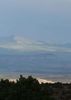
Once the snow finally melts, I'm sure the entire hike can be done in an hour, with plenty of time to snap a few photos along the way. The view from the top is certainly worth the effort. Even on a windy and dusty day like today, you can see a large chunk of North Western New Mexico - which gives an odd but stunning contrast of ponderosa forests, red rock cliffs, several enormous large lava plugs which rival even the famous Devil's Tower in height, all surrounded by green toped mesas and the ever changing colors of the high desert.

I met up with several groups at the summit who had come up the Southern route, and they had encountered little or no snow. One of the hikers, who was 20 days into the CDT trail mentioned that she had seen a solid flow of water coming out of Gooseberry Spring - which is of course where the trail gets it's name. I haven't lived here long enough to know how dependable that spring is, so I wouldn't count on it being a source of drinking water. According to my topo, it's located on the NW side of the South approach within the 1st mile of the hike - I'll post an update when I get a chance to confirm it's location.

Final notes: There's no water anywhere on Mt. Taylor, except for the various springs - which may or may not have water, and which may or may not be where the topo says they are. BRING YOUR OWN! Also, while you may get what appears to be a strong cell phone signal during the hike, don't count on being able to make a call. The only places I've gotten reliable service are on the summit itself, and a few of the forest roads on the south side of the mtn.

Getting there: Take Lobo Canyon Rd (547) 13.5 miles on pavement, then continue on 547 another 3 1/4 miles after it turns to dirt. Now, turn right on FR 453 at the sign for La Mosca LO. Once on FR 453, drive 4 miles to the saddle between the peaks (Mt Taylor and La Mosca), take the turn to the right - as opposed to continuing up to La Mosca lookout and it's "beautiful" collection of radio/cell towers. Continue about 200 yards and you should see a sign for the "Gooseberry Trail" - if you don't have a high clearance vehicle, you'll likely need to park at the fork in the road and walk in that last couple hundred yards.
_____________________
"Look deep into nature, and the you will understand everything better" Albert Einstein
 
May 31 2008
avatar

 Guides 73
 Routes 176
 Photos 10,174
 Triplogs 2,324

46 male
 Joined Sep 08 2006
 
Mount TaylorNorthwest, NM
Northwest, NM
Hiking avatar May 31 2008
JimTriplogs 2,324
Hiking7.00 Miles 2,100 AEG
Hiking7.00 Miles   4 Hrs      1.75 mph
2,100 ft AEG
 no routes
1st trip
Linked   none no linked trail guides
Partners none no partners
I took a road trip to Mount Taylor just north of Grants, NM to take in what should be the first of the four sacred peaks for the Navajo that I'll summit this summer. I'll hit Humphrey again this June, and then its off to Colorado to do Hesperus and Blanca in late July. The only one I haven't already done is Hesperus, but I want to get them all this summer.

Unless you share my arbitrary goal of hiking all the sacred Peaks, its probably not worth making a special trip to Grants to hike Mt Taylor. If you are passing by, it is a great scenic hike that is really easy. The trail is gentle and the views from the top are about a 270 degree version of what you get from Humphrey. Situated in a rural area of New Mexico there isn't much visitation to Taylor outside the hunting season, and there is some pleasant back country camping near the trailhead. This definetly made a really nice weekend get away for me.
_____________________
🍭
 
average hiking speed 2.14 mph

WARNING! Hiking and outdoor related sports can be dangerous. Be responsible and prepare for the trip. Study the area you are entering and plan accordingly. Dress for the current and unexpected weather changes. Take plenty of water. Never go alone. Make an itinerary with your plan(s), route(s), destination(s) and expected return time. Give your itinerary to trusted family and/or friends.

helpcommentissue

end of page marker