|
| | | |
| |
|
| Hiking | 11.07 Miles |
1,100 AEG |
| | Hiking | 11.07 Miles | 4 Hrs 30 Mns | | 2.46 mph |
| 1,100 ft AEG | | | | |
|
|
| |
| Linked |
|
none
[ show ]
| no linked trail guides |
| Partners |
|
none
[ show ]
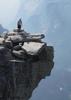
| no partners | | Part 2 of day 3 hikation. After enjoying Glacier Point with my wife for a coupe of hours, we headed down via the Panorama Trail. The first 2.5 miles is pretty much all down hill along the exposed northern flank of Glacier Point. There are several switchbacks, until you get to a long stretch that gradually descends eastward. As you descend, Illilouette Falls comes into view. One of three falls that were actively flowing in Yosemite Valley during my visit. At .7 miles my wife turned around and headed back to the car. She was going to take in the scenes from the car and meet me at the bottom. At 1.6 miles there was a split in the trail (can't remember what destinations were being offered down that eastern avenue). At 2.5 miles reached Illilouette Falls. Wandered upstream a bit to get pictures. (Wife insisted that I take the camera with me on the hike. Dang thing strapped, chafed, around my neck, kept thumping into my chest the entire journey. I think I bruised my chest. Got close to 200 hundred pictures, but it is the first, and last time I take a camera on a hike. Talk about a pain in the neck! Literally!). After Illilouette, comes the only major climb of the hike. Garmin showed about 1100 ft in 1.1 miles. Not sure about the elevation gain. Another write up mentioned 700ft. Took some more pictures from Panorama Point. Very scary.  Straight drop. 1000 ft(?). No fencing. Not for the faint of heart. (If anyone finds a heart, please mail it to Brian, post box....I think I lost mine somewhere around that cliff) Straight drop. 1000 ft(?). No fencing. Not for the faint of heart. (If anyone finds a heart, please mail it to Brian, post box....I think I lost mine somewhere around that cliff)  At 4.7 miles, hit another split in the trail. Took a picture of the trail sign for later reference. None of the mentioned destinations seem to be close by, all seemed to be 10 miles or more away. At about 7 miles, hit Neveda Falls. The lay of the land allowed for some great photo ops. Took a short break here to enjoy the views. Ironically, after having read some other write ups (after my hike) I think I missed the Mist Trail. After Neveda Falls, I backtracked to the Panorama Trail, which was now being called the John Muir Trail. I think if I had continued toward Half Dome, from Nevada Falls, I would have intersected the Mist Trail. As it was I continued down the Panorama/Muir Trail to Vernal Falls. By this time the battery was dying in the camera and I was running late for my meet up with my wife, so I stopped being a snap-happy tourist and started hiking. Took the quicker of two routes from Vernal. Had another Piestewa flashback, as I encountered 100+ plus stairs leading down from the Falls. Similar to what you see near the top of Piestewa. The last mile of the Panorama/Muir s paved. In fact there were indications that at one time the trail was paved all the way to Illilouette Falls, or at least prevalently so. Once again Mother Nature had eroded all but traces of it. Trail was busy all the way through, but got busier the closer you got to the bottom. Wildlife was minimal. A lot of squirrels and one very in afraid deer. At 4.7 miles, hit another split in the trail. Took a picture of the trail sign for later reference. None of the mentioned destinations seem to be close by, all seemed to be 10 miles or more away. At about 7 miles, hit Neveda Falls. The lay of the land allowed for some great photo ops. Took a short break here to enjoy the views. Ironically, after having read some other write ups (after my hike) I think I missed the Mist Trail. After Neveda Falls, I backtracked to the Panorama Trail, which was now being called the John Muir Trail. I think if I had continued toward Half Dome, from Nevada Falls, I would have intersected the Mist Trail. As it was I continued down the Panorama/Muir Trail to Vernal Falls. By this time the battery was dying in the camera and I was running late for my meet up with my wife, so I stopped being a snap-happy tourist and started hiking. Took the quicker of two routes from Vernal. Had another Piestewa flashback, as I encountered 100+ plus stairs leading down from the Falls. Similar to what you see near the top of Piestewa. The last mile of the Panorama/Muir s paved. In fact there were indications that at one time the trail was paved all the way to Illilouette Falls, or at least prevalently so. Once again Mother Nature had eroded all but traces of it. Trail was busy all the way through, but got busier the closer you got to the bottom. Wildlife was minimal. A lot of squirrels and one very in afraid deer. |
| _____________________
| | |
|
|
|
 Route Editor