username
X
password
register
for free!
help
ArticlesGuidesRoutes
 
Photosets
 
 Comments
triplogs   photosets   labels comments more
Vivian Creek Trail - 5 members in 12 triplogs have rated this an average 4.8 ( 1 to 5 best )
12 triplogs
login for filter options
Oct 02 2023
avatar

 Guides 7
 Routes 79
 Photos 2,440
 Triplogs 652

34 male
 Joined Jan 10 2010
 Pomona, CA
Vivian Creek TrailBig Bear - Jacinto, CA
Big Bear - Jacinto, CA
Hiking avatar Oct 02 2023
PatrickLTriplogs 652
Hiking19.00 Miles 5,600 AEG
Hiking19.00 Miles   10 Hrs      2.08 mph
5,600 ft AEG      53 Mns Break16 LBS Pack
 
1st trip
Linked   none no linked trail guides
Partners none no partners
I created the HAZ page for Vivian Creek Trail about 12 years ago. Coupled with the fact that I grew up in the nearby town of Yucaipa, this hike has been on my radar for a very, very long time. Spent most of September training, and well, today (yesterday) was the day.

I left Phoenix at 12am Monday. Drove straight through to Uncle Ray's Donuts on 3rd St and County Line for a pick-me-up. Reached Forest Falls and started hiking at 5:38am. It was 37 degrees at the start and considering the amount of elevation gain on this one, I don't think it warmed up until after the peak.

The views of San Jacinto and Coachella Vallely around mile 7 are incredible. The remaining 2.3 miles to the peak are a doozy. I required numerous breaks and sustenance to make it through. I thought my knees were in trouble once I topped out - thankfully they just needed rest. Views from the top were great, albeit limited because of the air quality. Didn't stay for too long as I still had to get down and drive home.

The increasing clouds along the descent were fantastic. They initially built up along Yucaipa Ridge, then spilled over to the rest of the range. High Creek Camp was pretty crowded on the way down - can't imagine what it looks like on a weekend.

The descent was uneventful yet beautiful. I moved as fast as my knees would let me and made up a bunch of time, reaching the car in exactly 10 hours. I changed into some clean clothes and drove to the closest Baker's Drive-Thru (highly recommended) for calories. The drive home was not radical. Pretty sure someone else took the wheel for the last two hours because it's all a blur. :scared: Wouldn't recommend this as a day trip but sometimes you gotta do what you gotta do.

water 1 out of 5water 2 out of 5water 3 out of 5water 4 out of 5 Vivian Creek Heavy flow Heavy flow
Lots of water, plenty of spots to filter from
_____________________
  2 archives
Sep 16 2023
avatar

 Guides 12
 Routes 192
 Photos 863
 Triplogs 356

42 male
 Joined Nov 30 2015
 Phoenix, AZ
San Gorgonio Loop, CA 
San Gorgonio Loop, CA
 
Run/Jog avatar Sep 16 2023
ShatteredArmTriplogs 356
Run/Jog23.50 Miles 6,250 AEG
Run/Jog23.50 Miles   8 Hrs   19 Mns   3.00 mph
6,250 ft AEG      29 Mns Break
 no routesno photosets
1st trip
Linked   linked  
Partners none no partners
Quick trip to California, decided to give San Gorgonio another go. Was planning on starting later, but I woke up at 11:30pm after going to bed a couple hours earlier, and decided I may as well start driving - got to the TH by 6am. Impeccable timing.

Decided to go up Vivian Creek and down Falls Creek (got a permit for Momyer/Falls, not sure how loops are supposed to work permit-wise). Vivian Creek trail was enjoyable overall, hiked like 95% of it. Grade isn't too steep until you gain the ridge above High Creek Camp, but it climbs efficiently. It's about as mellow as a trail that climbs 5k feet in 9 miles can be! Scenery was nice the whole way up - one charred burned section - but looking down into the South Fork of the Whitewater, it's all burned to a crisp...

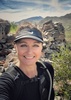
Summit view was nice, only spent a few minutes up there. The low-lying fog filling the valley on the Santa Ana side was cool to see; made the San Bernardino and San Gabriel mountains look like giant islands.

Didn't really want to, but headed down towards Falls Creek (mostly to keep it legally kinda above-board). The 3 mile stretch of the San Bernardino Divide trail down to Dollar Lake Saddle was really fun to run down, and probably one of my favorite stretches of trail in Southern California.

Falls Creek trail was way more overgrown than I remembered (maybe because I was heading uphill last time), and didn't see anybody until about a half mile before Alger campsite. Looks like there might be a trail down from a little west of the Dobbs Cabin turnoff that could've shaved off 2-3 miles, but it wasn't on my topo maps...

Started seeing a lot more hikers past Alger Creek, also started getting a little warm. Then just had to do a miserable 1.6 miles back up the road, which is really definitely not recommended for pedestrians - probably should've started with this stretch, but then I wouldn't have been able to stop in the store for a cold Coke...

Really cool mountain, would like to check out more of the trails on the NE side.
_____________________
  2 archives
Aug 31 2023
avatar

 Guides 4
 Routes 491
 Photos 10,890
 Triplogs 1,257

55 male
 Joined Nov 20 2012
 Phoenix, AZ
San Gorgonio, CA 
San Gorgonio, CA
 
Hiking avatar Aug 31 2023
BiFrostTriplogs 1,257
Hiking18.90 Miles 5,845 AEG
Hiking18.90 Miles   11 Hrs   13 Mns   1.91 mph
5,845 ft AEG   1 Hour   18 Mns Break
 
1st trip
Linked   linked  
Partners partners
slowandsteady
After viewing this peak from San Jacinto it was finally time to climb the high point of Southern California. We tried to do San Gorgonio back in 2018 but fire closure from the Valley Fire ended that. Sadly there was another San Gorgonio fire in 2020 called the El Dorado Fire started by pyrotechnics at a gender reveal party. Interesting Wiki article read for those interested.

Back to the hike. We started from the Vivian Creek Trailhead about 530am in mostly dark conditions. About 1/2 mile in there is a creek crossing that other posts mentioned wet feet but we were able to cross with no issues. Once across the creek the trail goes very vertical for 1.5 miles and probably the steepest part of the whole hike. Eventually we reached Vivian Creek Campground a nice area with lots of shade and plenty of water flowing in the creek. Continuing on we made it to the second camp Halfway Campground about another 1.3 miles up trail.

Not wanting to stop just yet we continued on to the next one at High Creek Camp and took a good break. We had gone 5.5 to 6 miles depending on the GPS and gained several thousand feet to put us at about 9300. After the break we continued up some really nice switchbacks that eased the grade somewhat. At the end of the switchbacks it reached a ridge around 10,000 elevation where we could finally see almost summit. Took another quick breather as the first hiker we'd seen passed us.

From here the trail continued up a series of sometimes steep switchbacks mixed with long gradual upward traverses as the higher elevation started to kick in. Eventually we reached the junction with the divide trail at about 11,200. Took another break and at least I was really sucking wind but fortunately it's only a mile and couple hundred more feet gain to the summit.

Finally after the quick break we reached the summit and just before the hiker who passed us earlier was headed back down. That meant we had the whole summit to ourselves :D Took an extra long break to recover and just enjoy the summit. Just as on San Jacinto nobody showed up during the break. Only other creatures on the summit were some very aggressive Pikas...not their first rodeo!

After the nice long break it was time to hike back down the same trail. Great timing too because 5 minutes into the descent the next hiker was making her way to the summit. It was much easier to enjoy the views going downhill which were pretty cool on the top 2 miles. Eventually we dropped off the high ridge and switchbacks down to High Creek Camp where we took another break.

Break over we continued down and only encountered one other person for total of 3 on the day. We reached the creek crossing at the bottom and at least this time it was daylight enough to see some scenery. Across the creek and back at the trailhead just before 5pm. Toughest hike for sure on the week but well worth the effort!
_____________________
  1 archive
May 21 2022
avatar

 Guides 99
 Routes 1,485
 Photos 16,072
 Triplogs 1,375

male
 Joined Jan 07 2017
 Fountain Hills,
San Gorgonio Mountain, CA 
San Gorgonio Mountain, CA
 
Hiking avatar May 21 2022
DixieFlyerTriplogs 1,375
Hiking18.92 Miles 5,496 AEG
Hiking18.92 Miles   9 Hrs   42 Mns   2.23 mph
5,496 ft AEG   1 Hour   14 Mns Break
 
Linked   linked  
Partners none no partners
Route Scout Route Recorded  on Route Scout | Pop | Map | Popup | MapDEX
I hiked up to San Gorgonio Mountain 3 years ago and decided to do it again.

It was a near perfect day for the hike, although being on a Saturday the trail had more people on it than I prefer.

This is a scenic hike, and it will give you a good workout.

There was one section of snow about 30 feet long on the trail; other than that, the trail was in summer conditions.
 Culture
 Culture [ checklist ]
[ checklist ]  Throwing a Wendy
_____________________
Civilization is a nice place to visit but I wouldn't want to live there
 
Jul 31 2021
avatar

 Routes 386
 Photos 49
 Triplogs 792

43 female
 Joined Jun 23 2015
 Phoenix, AZ
Vivian Creek TrailBig Bear - Jacinto, CA
Big Bear - Jacinto, CA
Hiking avatar Jul 31 2021
emilystardustTriplogs 792
Hiking21.12 Miles 6,151 AEG
Hiking21.12 Miles   11 Hrs   3 Mns   2.09 mph
6,151 ft AEG      57 Mns Break
 no routesno photosets
1st trip
Linked   none no linked trail guides
Partners none no partners
We started about 7 am and got fortunate with cloud cover most of the ascent. I felt a little nauseous for about a mile on the way up but luckily the trail leveled out a little and I could catch my breath for the last part. Thunder in the distance shortly after we summited, so we took a quick photo and headed below the tree line for some much needed rest and food. Everyone was very friendly and encouraging on the trail, congratulating folks near and at the summit.
_____________________
 
Jun 05 2020
avatar

 Routes 7
 Photos 1,242
 Triplogs 61

57 female
 Joined Nov 21 2015
 Phoenix
Vivian Creek TrailBig Bear - Jacinto, CA
Big Bear - Jacinto, CA
Hiking avatar Jun 05 2020
PicklesTriplogs 61
Hiking19.47 Miles 5,539 AEG
Hiking19.47 Miles   10 Hrs   31 Mns   2.20 mph
5,539 ft AEG   1 Hour   41 Mns Break
 
1st trip
Linked   none no linked trail guides
Partners partners
te_wa
Route Scout Route Recorded  on Route Scout | Pop | Map | Popup | MapDEX
Vivian Creek Trail to San Gorgonio summit. te_wa and I started this hike at 6:40 am and made it back to the car around 5:00. The weather could not have been better. Definitely some higher wind gusts the closer we got to the summit but nothing brutal.
The altitude of Gorgonio picked at us more than the altitude of Mt Charleston (Nevada) that we did last year. We both felt more tingly and loopy and joked about hitting up an oxygen bar on our way home.
This was a beautiful hike as it showcases the natural resources that are so abundant in CA! We had awesome views of San Jacinto, the mountain we tried to summit last year before it kicked us off less than two miles from the summit with a freak snowstorm! Jerk! I couldn't stop looking at it from Gorgonio! For me personally, Jacinto was far more challenging than Gorgonio but that isn't to say this was easy peasy...it isn't! But Mike and I are a great team out there and we made sure we reached that summit and got back down relatively unscathed!
 Culture
 Culture [ checklist ]
[ checklist ]  HAZ Food
_____________________
 
Jun 05 2020
avatar

 Guides 3
 Routes 2
 Photos 1,156
 Triplogs 338

53 male
 Joined Aug 22 2003
 Mesa
Vivian Creek TrailBig Bear - Jacinto, CA
Big Bear - Jacinto, CA
Hiking avatar Jun 05 2020
te_waTriplogs 338
Hiking8.90 Miles 5,419 AEG
Hiking8.90 Miles
5,419 ft AEG
 no routes
1st trip
Linked   none no linked trail guides
Partners partners
Pickles
started our summer of summits off with a good challenge! we had eyed Gorgonio since last year when we did cactus to clouds. the time was right to hit up this big 'ol peak and it really tested the legs after "warming up" with a 9.6 mile, 2600' trek up Tahquitz peak the prior day. fun summit, wonderful weather and GREAT company! Lesa (pickles) really charged up that hill, and i did my best to keep up.. what a perfect way to re-connect, re-evaluate, and re-examine our deep connection to nature, hiking, and each other. would not trade days like this for the world.. :DANCE:
 Culture
 Culture [ checklist ]
[ checklist ]  Summit Register Log
 Named place
 Named place [ checklist ]
[ checklist ]  San Gorgonio Mountain
_____________________
squirrel!
 
Jul 30 2019
avatar

 Routes 61
 Photos 1,008
 Triplogs 224

44 male
 Joined Aug 19 2009
 The Basin
Vivian Creek TrailBig Bear - Jacinto, CA
Big Bear - Jacinto, CA
Hiking avatar Jul 30 2019
survivordudeTriplogs 224
Hiking18.84 Miles 5,400 AEG
Hiking18.84 Miles   10 Hrs   42 Mns   2.07 mph
5,400 ft AEG   1 Hour   35 Mns Break
 
1st trip
Linked   none no linked trail guides
Partners none no partners
Route Scout Route Recorded  on Route Scout | Pop | Map | Popup | MapDEX
I heard about this one from a friend of mine that lives in California. A week long family vacation to San Diego had a free day for me to get away so I decided to go to the top of Southern California! This was a very beautiful and challenging hike. Even the drive in was scenic. The parking lot still had several spots available at 6:30AM, but there was no one in the Kiosk to buy an Adventure Pass Parking Pass and the Elkhorn store was closed, so I left a note on the windshield instead and NO TICKET! :app: .
The bugs were ferocious. After crossing the Mill Creek, and this thing was massive, the hike goes on a pretty steady incline up 1000 ft or so for a little over a mile. I felt it was pretty mild compared to what I have read about. The first camp was right around the corner from there and there were several deer that first were being stubborn about getting off the trail and out of the way and then followed me on the trail for another 1000 feet. Water stops were brief as the mosquitoes had acquired a strong thirst for my blood at that point. The next section of the hike was just stunning. There were huge pines and spruce and firs that towered above the rock formations covered in bright green ferns and other foliage. Then there were giant mountain tops and ridgelines above all that. It was one of the most majestic places I have ever been to. I really felt a great sense of gratitude to be there (and all alone!) at that time. After several miles and another 1000ft gain, I reached High Creek Camp. I stopped here for a short break and water fill for the final push. After High Creek, the switchbacks were relentless and brutal. I slowed down quite a bit after I hit 11k. Took a short rest just above the tree line and the sunshine felt so great up there. Made the final push to the summit through some cool areas with quite a bit of snow still left up there. Rested at the top and chatted with locals for a good 40 minutes before I headed back down. I felt great and was making a speedy pace, but my knees had other thoughts, so it was a slow and methodical decent instead. It took me just about 6 hours to summit and about 4 to get down. That includes many breaks going up and 15 minutes to fix my camelback tube. I was very impressed with myself and my pace and my California friend also was impressed that I tried to tackle this all in one day. There were far less people up there that I was expecting. Most people were just day hiking the mountain, but there were several groups of campers soaking up a few days. I would love to spend more time in this area. I will make sure to bring the bug spray.
 Meteorology
 Meteorology [ checklist ]
[ checklist ]  Snow

water 1 out of 5water 2 out of 5water 3 out of 5water less than max Camp Creek Medium flow Medium flow

water 1 out of 5water 2 out of 5water 3 out of 5water less than max High Creek Medium flow Medium flow

water 1 out of 5water 2 out of 5water 3 out of 5water less than max Vivian Creek Medium flow Medium flow
_____________________
“There is nothing that exists outside the thought of the immediate moment.”
 
Jul 11 2019
avatar

 Guides 99
 Routes 1,485
 Photos 16,072
 Triplogs 1,375

male
 Joined Jan 07 2017
 Fountain Hills,
San Gorgonio Mountain, CA 
San Gorgonio Mountain, CA
 
Hiking avatar Jul 11 2019
DixieFlyerTriplogs 1,375
Hiking19.00 Miles 5,513 AEG
Hiking19.00 Miles   9 Hrs   7 Mns   2.51 mph
5,513 ft AEG   1 Hour   32 Mns Break
 
Linked   linked  
Partners none no partners
San Gorgonio Mtn has been on my radar screen since last month when I hiked up to nearby Mt. San Jacinto, and with the weather still being good for the hike, Tracie and I decided to check this hike out.

This was an out-and-back hike on the Vivian Creek Trail in Forest Falls, CA. It was pretty much uphill all the way to the summit, and then downhill all the way back. The trail was easy to follow for the most part, although I occasionally referred to the default GPS track on HAZ for the Vivian Creek Trail. The GPS track was very accurate!

The hike was pretty tough (as the distance and elevation gain would suggest), but it was not as strenuous as I thought that it was going to be. The hike went through 2-3 ecosystems, and I enjoyed the scenery. However, I think that I liked the Mt. San Jacinto hike via the Deer Springs Trail better than this one.

This hike would be of interest to any peakbaggers: San Gorgonio Mtn. is the highest peak in Southern California, and in terms of topographic prominence it is the 7th most prominent peak in the continental US. Trivia buffs might recall that San Gorgonio Mtn.has been the scene of several notable plane crashes, including separate plane crashes that killed Frank Sinatra's mother and Dean Martin's son.
wildflower observationwildflower observationwildflower observationwildflower observationwildflower observation
Wildflowers Observation Isolated

water 1 out of 5water 2 out of 5water 3 out of 5water 4 out of 5 High Creek Heavy flow Heavy flow

water 1 out of 5water 2 out of 5water 3 out of 5water 4 out of 5 Vivian Creek Heavy flow Heavy flow
_____________________
Civilization is a nice place to visit but I wouldn't want to live there
  1 archive
Aug 09 2015
avatar

 Routes 1
 Photos 2,050
 Triplogs 425

46 male
 Joined Sep 16 2011
 Phoenix
Vivian Creek TrailBig Bear - Jacinto, CA
Big Bear - Jacinto, CA
Hiking avatar Aug 09 2015
VolcanoCLMBRTriplogs 425
Hiking21.24 Miles 6,419 AEG
Hiking21.24 Miles   9 Hrs   45 Mns   2.18 mph
6,419 ft AEG
 no routes
1st trip
Linked   none no linked trail guides
Partners none no partners
And our exploration of SoCal peaks continue, now with San Gorgonio mountain. A grueling 19 mile 6000AEG trail to its summit from Vivian Creek trail.
This mountain compared with Mt. Baldy nearby sees very little traffic due to its daily permit limit. We started at 545AM followed the jeep road for the first 1/4 mile or so until we reached the almost dry Mill Creek, from this very spot just cross the river and you will see the trail sign......we made the mistake of going up the creek 1.5 miles and had to backtrack, it sucked but we marched on and made it to the summit at about noon, stayed about 20 minutes then quickly made our descent and made it back to the TH at 345PM.
It was a great hike with great views once we got close to the tree line and above. There are a few dispersed camp spots along the way up but they also require a backcountry permit.
 Named place
 Named place [ checklist ]
[ checklist ]  San Gorgonio Mountain
_____________________
The world is my playground!
 
Aug 08 2015
avatar

 Routes 1
 Photos 29,225
 Triplogs 1,447

45 female
 Joined Jan 18 2011
 In the Wild
Vivian Creek TrailBig Bear - Jacinto, CA
Big Bear - Jacinto, CA
Backpack avatar Aug 08 2015
LucyanTriplogs 1,447
Backpack17.80 Miles 5,419 AEG
Backpack17.80 Miles
5,419 ft AEG
 no routes
1st trip
Linked   none no linked trail guides
Partners none no partners
San Gorgonio is the tallest mountain in Southern California. At 11,503′, “Old Grayback” provides an excellent high altitude training and great "escape the heat" summer option.
Friday we left town and headed west towards Los Angeles. We camped at the Barton Flats campground right off the 38. Saturday, we backpacked the Vivian Creek trail and camped up at roughly 7,000ft. After setting up camped we grabbed our day packs and day-hiked up to the San Gorgonio summit without the burden of our backpacks. We took our time hiking up and took several pictures. It was a beautiful day and great visibility. Once we got to the summit we hang out and had lunch. After about 1.5 hours we hiked back to the campsite and enjoyed hot dinner. Sunday we packed up and left camp early at the morning.
 Named place
 Named place [ checklist ]
[ checklist ]  San Gorgonio Mountain
wildflower observationwildflower observationwildflower observationwildflower observationwildflower observation
Wildflowers Observation Isolated

water 1 out of 5water 2 out of 5water 3 out of 5water less than max Vivian Creek Medium flow Medium flow
_____________________
  1 archive
Jul 27 2012
avatar

 Guides 93
 Routes 397
 Photos 4,984
 Triplogs 4,124

49 male
 Joined Jun 20 2003
 Tucson, AZ
Vivian Creek TrailBig Bear - Jacinto, CA
Big Bear - Jacinto, CA
Hiking avatar Jul 27 2012
fricknaleyTriplogs 4,124
Hiking17.77 Miles 5,738 AEG
Hiking17.77 Miles   7 Hrs   15 Mns   2.96 mph
5,738 ft AEG   1 Hour   15 Mns Break15 LBS Pack
 
no photosets
1st trip
Linked   none no linked trail guides
Partners none no partners
I hiked the southern California high point on friday with Michelle's uncle dennis. San Gorgonio sits at 11,503 along the southeast San Bernardino mountains. I've been wanting to do this one forever it seems and it sure was worth the wait.

after an immediate steep climb a peaceful stretch through simply MAGNIFICENT big growth forest rewards you before resuming several additional climbs. awesome views along the way on a great trail in perfect weather and we were loving every minute of it. the top is above timber line and affords spectacular 360 views - including mighty San Jacinto.

perfect day. followed that up with a feast at Portillos in Moreno Valley. for those of you familiar with Chicago, you know exactly what i'm talking about :y: :y: :y: california!!
wildflower observationwildflower observationwildflower observationwildflower observationwildflower observation
Wildflowers Observation Light
_____________________
hi
 
average hiking speed 2.32 mph

WARNING! Hiking and outdoor related sports can be dangerous. Be responsible and prepare for the trip. Study the area you are entering and plan accordingly. Dress for the current and unexpected weather changes. Take plenty of water. Never go alone. Make an itinerary with your plan(s), route(s), destination(s) and expected return time. Give your itinerary to trusted family and/or friends.

helpcommentissue

end of page marker